
-
 6645 Hits
-
 80.49% Score
-
 12 Votes
|
|
Mountain/Rock |
|---|---|
|
|
44.52909°N / 9.50490°E |
|
|
Emilia-Romagna, Liguria |
|
|
Hiking, Mountaineering, Ice Climbing, Mixed, Scrambling, Via Ferrata |
|
|
Spring, Summer, Fall, Winter |
|
|
5692 ft / 1735 m |
|
|
Overview
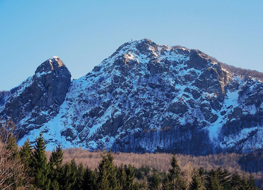
Monte Penna 1735 m
Monte Penna 1735 m is a beautiful rocky pyramid located in the Northern Apennines, on the border between Emilia-Romagna and Liguria (provinces of Parma and Genova) and overlooks the magnificent namesake beech forest. This forest is dense and very wide and perfectly preserved. In reason of its majesty and its steep slopes Monte Penna is the most representative mountain of the group Penna-Aiona-Maggiorasca, although not the highest. It is in fact exceeded in height by Monte Maggiorasca. In fact this latter with a height of 1804 m reaches and exceeds the 1800 meters of altitude.

|

|

|

|
The peak is a pyramid in shape of a triangle, with a Northern wall of alpine beauty, steep and formed of ophiolitic rock, which suddenly emerges from the dense forest below, while the South side appears gentle and luxuriant. Observing the wall from the Northern side a deep fracture gives rise to the adjacent Pennino 1678 m, a steep rocky tower joined to the main summit by the Forcella Penna-Pennino.
Monte Penna is located inside an area of great environmental and landscape beauty and is attended throughout the year by fans of multiple disciplines: from hikers to climbers during the summer, from ice-climbers during the winter to the cross-country skiing and hikers with snowshoes along the magnificent forest rings that wind around the mountain. The views from the summit are broad and open, from the Tyrrenian sea to the South West to the close Pennino and Monte Maggiorasca and further away to the Alpi Apuane.

Getting There
The starting point to climb the mountain is the wide parking lot near the Casermette del Penna hut. Monte Penna is located on the border between the provinces of Parma and Genova and very close to the province of Piacenza, so it's usually reached by different sides.

- from Parma across Pontestrambo - Take the highway Parma-La Spezia, exit Borgotaro, pass Borgotaro and Bedonia, pass Bedonia and when you reach the locality Pontestrambo, leave the main road and turn right towards Passo della Tabella, where you continue on the asphalt road to the Passo del Chiodo, then take the road to Casermette del Penna
- from Parma across Passo del Tomarlo - Take the highway Parma-La Spezia, exit Borgotaro, pass Borgotaro and in Bedonia take the road to Anzola and Passo del Tomarlo. From Passo del Tomarlo turn to left on the road to Passo del Chiodo-Monte Penna, here take the road to Casermette del Penna and Casa Forestale
- from Lavagna follow the signpost to Cogorno and Carasco, then take the road SS586 in the direction of Santo Stefano d'Aveto. Cross the Passo della Forcella and continue driving to the villages of Cabanne and Rezzoaglio. In Rezzoaglio take the road SP654 towards Santo Stefano d'Aveto, pass Magnasco and Villanoce and reach Gramizza. Here follow the road signposted Foresta del Penna, pass Amborzasco and Casoni, reaching the Rifugio Casermette del Penna
- from Piacenza take the road SP 654 (Val Nure) and reach the Passo del Tomarlo, from here to Passo del Chiodo and Rifugio Casermette del Penna
Monte Penna crossing
Monte Penna NE ridge - SW flank crossing
Difficulty: EEA (expert hikers with equipment)
Equipment: the route is well equipped with iron ropes on the most difficult steps
Difference in level: 343 m. from the parking lot near the Rifugio Casermette del Penna
Exposure: NE, SW
Beautiful ring hike that allows the crossing of Monte Penna from North to South with limited difference in height From the summit the panorama is breathtaking, from the Alpi Apuane to the Tyrrenian sea, from the isle of Corsica to the close Monte Maggiorasca. The itinerary is fully completely marked and in good condition it doesn't present particular difficulties. The upper section is equipped with iron chains and requires a minimum of experience. It may be more challenging with wet rock or snow and ice.

|

|
Route description
From the Casermette parking lot (1392 m), follow the asphalt road to the South (towards Rezzoaglio) for a few tens of meters: on the left it starts a path, signposted "Monte Penna" and marked by yellow triangles on the trees, entering the dense forest of beautiful beechs. The path goes round to the North to the Pennino rocky tower and exits the forest below the rocky saddle located between Monte Penna (on the left) and Pennino (on the right). Here it starts the path equipped with iron chains. From the saddle the trail follows the North East ridge of Monte Penna along some iron chains and overcoming easy rocks, leading rather quickly to the summit of Monte Penna (small church and statue of the Madonna). 1 hours.

|

|
The descent is made along the SW side, a simply walk. The marked path goes along the beechs' forest down to Passo dell'Incisa 1463 m, from where you must follow to the right the forest road for about 1.5 km. After passing the wood cabin of "Falegnameria nel Bosco" (Carpentry in the wood) the track leads to the province road near the starting point and the parking area of the Casermette ( 2 hours overall for the entire ring).
|
|

|
Red Tape
No fees no permits required. Monte Penna is located inside the Parco Naturale Regionale dell'Aveto, a protected area of considerable natural and landscape interest. This park shows a high level of environmental preservation, so let's respect the common rules for the preservation of the environment.
When to Climb
All year round. There are various activities that can be carried out on the mountain, from climbing to Via ferrata, from walking to the most difficult ice and mixed routes during the winter season.
Hiking grades of difficulty
T - Turistico (Tourist): Itineraries on wide, clear and well worn paths, sometimes on mule tracks or gravel roads. The routes are never exposed, don't give any orientation problems and don't exceed 2500 meters of altitude. Suitable also for children
E - Escursionisti (Hikers): Itineraries on marked trails, even narrow and with possible steep and impervious sections. They are never exposed and don't give any orientation problems. They can tread different kinds of ground, such as forests, gravel, meadows, pastures, easy rocks, etc.). They form the majority of the trails that wind up in the mountains and require a certain habit to walk; you need equipment suitable for the altitude and resistant footwear with soles suitable for rough terrain
EE - Escursionisti Esperti (Experienced Hikers): Itineraries for hikers with experience and good knowledge of the mountain. Some of these paths may have exposed sections, however brief, which require firm foot and no dizziness. They require the ability to adapt to particular terrain, such as steep grassy slopes or stretches of rocks with difficulties that can reach the 1st degree of the UIAA scale. They can also reach high altitudes (3000 m or more). Sometimes they may include unmarked sections, requiring a good sense of orientation. Snow slopes are possible, however which can be overcome without specific mountaineering gear (rope, harness, crampons, ice-axe)
EEA - Escursionisti Esperti con Attrezzatura (Experienced Hikers with equipment - The same as EE, in addition these routes require the use of via ferrata equipment (lanyards, harness, carabiners, heat sink, helmet). This kind of itineraries range from the trails with short easy and not much exposed sections, previously equipped with fixed ropes and iron pegs, to the true and more difficult Via Ferratas climbing on rocky walls or on aerial ridges and ledges, previously equipped with long stretches of iron ropes, iron steps, ladders without which proceeding would constitute a real climbing. It is necessary to know how to use the technical equipment and have a certain habit of exposure and mountaineering terrains.
Huts

- Rifugio Casermette del Penna
- Rifugio Monte Penna
- Rifugio Faggio dei Tre Comuni
Meteo
Meteo ARPA Emilia-Romagna
Meteo ARPAL Liguria
Guidebooks and maps

NEW - "Arrampicaparma" III updated edition - Alberto Rampini, Silvia Mazzani - IDEA MONTAGNA 2019
- "Appennino Ligure e Tosco-Emiliano" - M. Salvo, D. Canossini - Collana Guide Monti d'Italia TCI-CAI, 2003
- "Vette e sentieri in Val d'Aveto e valli circostanti" - Fabrizio Capecchi, Andrea Parodi - Andrea Parodi Editore