
-
 13697 Hits
-
 81.18% Score
-
 13 Votes
|
|
Mountain/Rock |
|---|---|
|
|
44.10768°N / 10.23359°E |
|
|
Hiking |
|
|
Spring, Summer, Fall |
|
|
6214 ft / 1894 m |
|
|
Overview
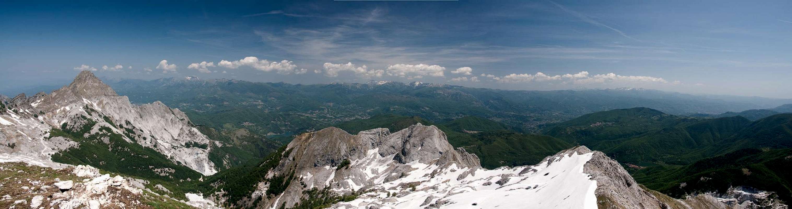
 On the Monte Tambura south ridge On the Monte Tambura south ridge |
Monte Tambura is the second highest mountain of the Alpi Apuane, the marble and limestone mountain range in the north of Toscana (tuscany). It is second only to nearby Monte Pisanino by 100m and exceed the third in line, Monte Cavallo by roughly 10m. On the other hand, Monte Tambura is one of the biggest mountains of the range, with its huge bulk easily visible from afar. It can be distinguished by its three-cornered shape with its three ridges pointing south, north-west and north-east. Among the highest mountains of the Alpi Apuane it is the most easily accessible one, thanks to two well-travelled routes, which head to Passo della Focolaccia in the north-west and Passo della Tambura in the south.
The first of these passes is rather typical for the range. Marble quarries can be found just about everywhere and the road to Passo della Focolaccia has been carved into the sides of the mountains in order to bring the valuable stuff down in the valleys. Even today, marble quarries litter the sides of Monte Sagro and Monte Cavallo with the highest one some 50m underneath the pass.
 |  |  |
The route across Passo della Tambura has a different story. Between 1738 and 1751 the Prince of Modena demanded a road to be built from his home to his property near the Tyrhenean Sea. Due to political complications the road had to built on the prince's property, which forced his engineer, the abbot Domenico Vandelli, to build it across the saddle of Passo della Tambura. Unfortunately the slopes on both sides are very steep so that it took all his engineering science to construct the endless switchbacks which lead across the pass. However, the prince's coach proved to large for the switchbacks which drove Vandelli into suicide.
 |  |  |
Today, the road has fallen into disrepair, though it definitely remains an excellent hiking route. The lower parts have been used for marble quarrying in the 19th century, before the advent of dynamite quarrying increased the size and output of the quarries. The upper part of the route, as well as the north-south running ridge between Monte Tambura and Monte Sella were fortified during the last months of WW II when Germans and Italian partisans fought for the mountain range. There are numerous artillery positions on the ridge and Passo della Tambura used to be of strategic importance at the time, being the easiest pass in the north of the mountain range.
 |  |  |
Monte Tambura itself is a brittle limestone mountain. Its size is huge and the south ridge, across which the normal ascent route runs, is rather long. It is also moderately exposed, especially near the two side summits, which need to be climbed befor reaching the top. Monte Tambura is an wonderful lookout mountain, with excellent close-up views into the northern Alpi Apuane. Drawback are the many marble quarries. On workdays the climb will not be exactly quiet. Therefore plan to climb the mountain on a Sunday.
360° Summit Panorama
  |
Getting There
 |
There are two reasonable trailheads for Monte Tambura, at both sides of the 18th century Via Vandelli. The eastern ascent starts near Vagli di Sopra, the western one near Rescetto
- Vagli di Sopra Trailhead:
- From Pisa or Firenze (Florence) take motorway A11 to Lucca
- Switch to SS12 in direction Abetone
- At Borgo a Mozzano switch to SP2
- At Castelnuovo di Gafagnana switch to SS445, direction Aulla
- At Poggio follow the signs to Vagli di Sotto
- Drive by Lago di Vagli on the northern shore and head for Vagli di Sopra
- Drive through the village and follow the signs Cave di Marmo
- Park your car before entering the marble quarries.
- Rescetto Trailhead:
- From Firenze (Florence) take motorway A11 to Lucca and Viareggio
- Switch to A12 north
- At the exit Massa turn off and drive through the town centre
- Follow the signs to Castagnetola, Cagliegliaand Rescetto
- Park your car at the end of the road.
Red Tape
 Podarcis tiliguerta
The Parco Naturale delle Alpi Apuane was established in 1985 to protect the nature as well as culture of the area within which the Alpi Apuane are located. Its overall size amounts to almos 21000 ha. A constant challenge is the presence of roughly 300 marble quarries which their impact on the environment. A hiker might easily find himself inside one of the quarries and is requested to follow signs and rules there.
The park's official website
Accommodation
Accommodation is relatively easy to find along the coast of the Tyrrhenean Sea. Viareggio, Massa, Carrara and La Spezia offer lots of hotel rooms as well as campgrounds. Either book them by travel office or go for a google search.On the other hand, to stay closer or within the range you can make use of Agriturismo, farms, which offer food and lodging. The site of the Natural Park has a selection of all kinds of accommodation of the area:
Weather Conditions
Maps & Books
Maps
- Alpi Apuane - Garfagnana
Kompass Verlag
1:50000
ISBN: 3-85491-852-6
- Geological Map Parco delle Alpi Apuane
1:50000
L. Carmignani, P. Conti, L. Disperati, P.L. Fantozzi, G. Giglia and M. Meccheri
Maps Online
Books
- Tuscany North / Toskana Nord
Wolfgang Heitzmann / Renate Gabriel (translation: Gill Round)
Rother Verlag
ISBN: 978-3-7633-4812-1 (English)
ISBN: 978-3-7633-4115-3 (German)
- Guida al Parco delle Alpi Apuane
Edited by: Giuliano Valdes
Series: Guide Felici
ISBN: 88-88327-91-6
- Guida all’Alta Via del Parco delle Alpi Apuane
Angelo Nerli
Felici Editore Srl
ISBN: 88-6019-006-1