
-
 4169 Hits
-
 74.92% Score
-
 5 Votes
|
|
Route |
|---|---|
|
|
46.36359°N / 12.90638°E |
|
|
Download GPX » View Route on Map |
|
|
Hiking |
|
|
Spring, Summer, Fall |
|
|
Half a day |
|
|
Easy/Medium hike up |
|
|
Overview
The shortest route on Monte Verzegnis is briefly described already on the main page, but this nice mountain deserves a bit more detailed description, so that you are able to ascend it without a special map.
The first importan information is that Monte Verzegnis is called also Monte Pizzat. You may find that inscription on some plates.
The direct route on Monte Verzegnis from Sella Chianzutan is a nice and diverse hike up. After you reach out of the woods, a nice path brings you on the broad Malga Val, then you gain the panoramic summit ridge and the very summit. Till Malga Val the path is marked, then to the summit not any more. But the path is evident and no marks are needed. The hike is not demanding. Till Malga Val the difficulty by the Swiss Hiking Scale would be T2/T1 and on the summit ridge one short section can be graded T3. No special gear is needed in summer conditions, only good shoes and poles. Time: 2 h 45 min (1000 m of altitude gain). See also the GPX track in the header!
Getting There
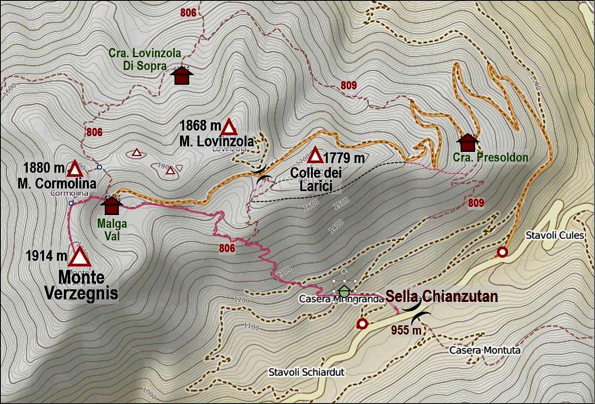
The trailhead is on Sella Chianzutan, 955 m. This road pass can be reached from Tolmezzo town, driving towards the SW through Verzegnis town. The approach from the south is longer. We park on a big parking place by the restaurant.
Route Description

Below Casera Mongranda

The view over Sella Chianzutan

On the summit ridge
As there are also other paths on the mountain, in the beginning some care is needed to take the right one. On the saddle you will not find any inscription for Monte Verzegnis, so consider the names of toponymes, mentioned on the map, illustrating this description.
From the restaurant we go a few meters by the main road towards the west and then deter on the marked path which goes up the mountain over the meadow. Our first goal is Casera Mongranda. When reaching the woods, the path turns left, goes through the woods, exits on the higher meadow and traverses it to the mountain road. There's the crossroads where you keep left - go to Casera Mongranda.
At the hut of Mongranda you leave the mountain road again. A good marked path leads you up and towards the left. In continuation you ascend through the woods. There are a few turns, but otherwise the path mostly traverses the slopes towards the left (NW direction). You come out of the woods on some 1500 m and soon afterwards you reach a crossroads. The right path goes up to the station of ancient material cableway, while we keep left again. The path starts traversing the slopes around the W ridge of Colle dei Larici. There are some panoramic points from which Monte Verzegnis and Monte Cormolina show themselves in full splendor. So we enter a shallow valley between Colle dei Larici and Monte Lovinzola, but we soon leave it towards the left. The path ascends over meadows almost to the road which comes from the right and then we have just a few more minutes to Malga Val, 1661 m.
From Malga Val the marked path goes towards the north, over Forcella Cormolina. We immediately leave that path (inscription there), following a steep, unmarked path, ascending towards the West. The path is a bit tiresome and not well beaten, but we soon reach a small col, cca 1800 m, between Monte Cormolina on the right and Monte Verzegnis on the left. If you would be following the marked path on Forcella Cormolina, you could also turn left there and traverse the summit of Monte Cormolina (or just below it) to reach the col 1800 m.
Now only good 100 altitude meters of Monte Verzegnis north ridge are ahead of us. The unmarked path is good and the ridge is not exposed. Only below the summit there is a short rock section, where we need to pull ourselves up a bit. Still, the passage is not exposed and we are soon on the summit.
Descent: As Fabrizio described it on the main page, you have many other variants to descend to Sella Chianzutan, so making a nice round tour.