
-
 2249 Hits
-
 70.83% Score
-
 1 Votes
|
|
Mountain/Rock |
|---|---|
|
|
38.59161°N / 111.95267°W |
|
|
Sevier |
|
|
Hiking |
|
|
Spring, Summer, Fall, Winter |
|
|
11047 ft / 3367 m |
|
|
Overview
Monument Peak is a rarely-visited 11,000-foot peak on the eastern side of the Sevier Plateau in Central Utah. Heavily wooded with scattered meadows, the area is prime habitat for some of the largest elk in the country. A high, forested ridge connects the peak to Glenwood Mountain and Signal Peak to the northwest. To the west is a bowl of beautiful meadows and small lakes that are unfortunately on private properties.Getting There
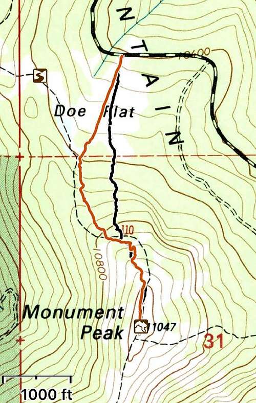
From Center Street and Main Street in Koosharem, drive westalong West Center Street. It curves right and turns into North 300 West Street.This becomes Forest Road 076 (Koosharem Canyon Road). Drive for 4.6 miles. Stayon the main dirt road, which turns into Forest Road 068 (Monroe Mountain Road).Take this about 7.8 miles to the north side of the peak. Directly north of thepeak along the road is a beautiful sloping meadow called Doe’s Flat. Park herealongside the road. For the longer version of the hike, you can continue on theroad for another 0.75 miles to Magleby Pass.Route
Hike straight uphill in the meadow. Once in the trees,within 100 yards, the faint ridge trail from Magleby Pass is discernible. Veer southeast(left) and follow the trail that fades in and out to the summit clearing.Round-trip Distance: 1.7 miles
Elevation Gain: 513 feet
Path of Least Resistance