
|
|
Route |
|---|---|
|
|
35.77045°N / 83.11155°W |
|
|
Download GPX » View Route on Map |
|
|
Hiking |
|
|
Straightforward Hike |
|
|
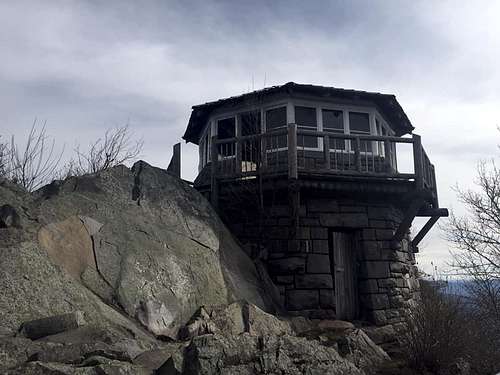
Overview
The Mount Cammerer Fire tower can be hiked to from many directions and trails. On Mount Cammerer SP Page under "getting there" four of these options are described. This is good, but omits what I believe is the most straightforward way to get to the tower.
Getting There
Coming from a few hours east in NC I used interstate 40, taking exit 451 in TN (the first exit after crossing the state line). After exiting I-40 you cross the Pigeon River and take a left onto the Waterville Rd and stay on for about 3.6 miles and take a right onto Mt. Sterling Rd. To simplify I placed Davenport Gap, Tennessee 37722 into Google Maps and it took me to the Appalachian Trail (AT) crossing.
Route Description
From Davenport gap go South on the AT. Continue on the AT for for approximately 5.3 miles. Early in this section you pass the Davenport Gap Trail Shelter. Later in this section, maybe around 4 to 5 miles in there's a rock outcropping with some decent views. The trail gains approximately 2,900' in this section.
After hiking approximately 5.3 miles on the AT you will reach a spur to the fire tower on the right hand side. This spur lasts only about 0.6 miles until it reaches the fire tower. This section is relatively flat, losing about 40'. NOTE: I've provided the route from my hike. It includes continuing south on the AT to Sunup Knob, this isn't necessary in reaching the tower.
Essential Gear
Add Essential Gear text here.
External Links
Add External Links text here.