

Viewing: 1-1 of 1

ktnbs - Aug 31, 2016 10:28 pm - Hasn't voted
very nicepost and cool pics
Viewing: 1-1 of 1
|
|
Trip Report |
|---|---|
|
|
50.59639°N / 115.405°W |
|
|
Download GPX » View Route on Map |
|
|
Aug 1, 2016 |
|
|
Mountaineering |
|
|
Summer |
I wonder if I will ever have the capability to climb that. That was my thinking last August as I stared at the towering, glaciated Mount King George while I traversed the Northover Ridge. Traversing the Northover Ridge in a day was the crowning achievement of my summer last year, but I never imagined what I would find myself doing this year. In June this year, I came to the realization that I had the skills to climb King George and I immediately set aside the August Long weekend to go get it.
I managed to find some interested partners and the trip was on. Unfortunately, on July 27 a conditions report came out that painted a dire picture of the conditions in the Rockies. The trip quickly fell apart and Plan Bs started taking form. Thomas and I decided to climb the South Ridge of Lorette and traverse to McGillivray on Sunday, and Cam and I were going to climb Birdwood on Monday. I drove out to Canmore late Saturday night in a raging thunderstorm and lay awake feeling uneasy about getting on a highline ridge the next morning.
Raff texted at about 10:30pm wishing me luck on King George. He mentioned that the conditions were amazing and he knew of two successful ascents earlier in the week. A feeling of regret washed over me. I had cancelled my dream climb to climb a route that was surely going to be cancelled by rain. After some thinking, I realized that I could still drive back to Okotoks that night, get my ice gear and drive to the trailhead for King George in decent time. I had already done most of the research for the route, so the idea was not too far fetched. I called Cam and Thomas who were both game, and by 10:50 I was on my way home to Okotoks. I packed and was in bed by 2:30am.
Cam and I met in the city at 10 am and we met Thomas in Canmore at 11. We arrived at the parking spot at 3:30, after a few wrong turns due to my poor math (or maff) skills. At 3:50 we hit the trail. The rain started almost immediately...
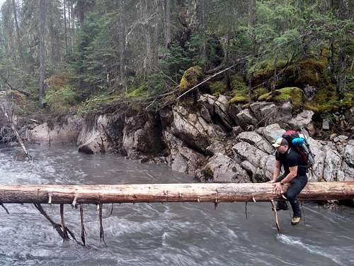
The first obstacle was encountered only moments after we started the route. To cross the Palliser River we had to go au chavel on a slippery wet log. The river was not wide, but it was deep and rushing. We had to unclip our backpack straps so that our packs would not drown us if we fell in. Every once in a while, we had to lift our legs over branches while trying to cling to nothing for balance. It was quite unnerving, especially because if we looked down for too long we would get dizzy from watching the water. It was a big relief to finally have all three of us safely across this section.
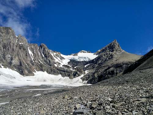
After the log we worked our way across a clear cut and found a surprisingly good trail on the other side. The trail followed the right bank of Fynn Creek for a few kilometres before veering right and starting to gain elevation. The trail steepened significantly but before long it mellowed out and pretty much disappeared. Then we reached an old moraine with great views of Mounts Prince George and Princess Mary. The rain stopped at this point as well and we were treated to great views of Mount Joffre.
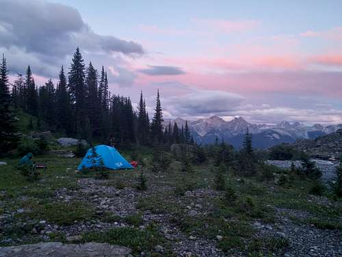
We had been told that the chockstone on the standard route to gain the George-Mary col was pretty ugly, so we decided to traverse West across the moraine and camp below the West flank of Princess Mary. We had to lose a bit of elevation and then climb up beside a waterfall. Our camp was just above the waterfall, and what a campsite it was. The ground was soft and flat, we had a water source nearby, and there were incredible views of the peaks to the south. What a sunset it was. The beauty was also compounded by the massive jagged peaks flanking the East, North and West sides of our camp. We had our tent pitched by 9 and were in bed by 10:30pm.
We woke up at 1:50am, scarfed down some breakfast, and started making our way up the valley at 2:35am. It was a new moon, so it was very dark and we could see almost nothing, making the route finding quite difficult. We made one or two mistakes, but nothing that set us back too much. We soon gained the George-Mary col and then bashed our way up scree to the base of the SE ridge.
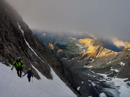
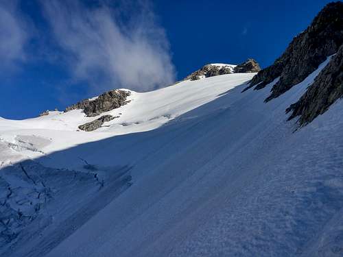
From there we started to see sunlight, and we made our way across a system of ledges below the West side of the SE ridge and soon found ourselves at the edge of the glacier. This spot gives breathtaking views of the hanging glacier. We donned our crampons and pulled out our ice axes and began to make our way across. The slope was about 40 degrees with a fairly firm crust. None of us broke through on the way up. Given the angle of the slope and the firmness of the snow, we elected not to rope up. In a rope team, if any of us had fallen it would have dragged all of us down to almost certain death. Beneath the steep slope was a massive cliff, and further up was an enormous crevasse. A slip here was not an option.
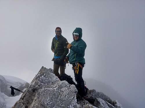
We made our way carefully, but fairly easily, up the slope. Unfortunately at this point we also climbed up into an isolated summit cloud. I led this section and kicked steps up for a ways. Soon we gained an ice bench below the summit and Thomas led us up a 40 degree snow and ice couloir. We gained the summit ridge in near whiteout conditions and followed the ridge until we stood on the summit at 7:50 am.
We were not treated to any views but this summit was still a huge milestone for me. A climb that had gone on my list a year prior, but I thought it would be as much as 5 years before I would be able to climb it. After some celebrations and congratulations, we left the foggy summit 40 minutes after arriving. We lingered for that long because we had hoped the clouds would clear. No such luck.
We descended the ice couloir to the bench and looked back at the summit. Only 15 minutes had passed the the summit was now totally clear. We debated going back for a moment but decided to stick to our guns and get out of there. The day only got nicer as we descended and the snow on the glacier was quite noticeable softer by the time we were crossing.
Thomas and Cam were able to plunge step down outside of our original track, but unfortunately I am not carrying enough weight and was unable to do so. I was forced back into our ascent track and twice the snow under my uphill foot gave way. I was not feeling overly comfortable here and was quite relieved when I got my feet back on solid rock.
At the edge of the glacier we removed our crampons and glacier gear and rested for a half hour. Before we left we witnessed a 4 fist sized boulders break free of the SE ridge and crash down right where we had walked. This was a good affirmation for our decision not to go back to the summit. We would have been right in the area when those rocks came down, and even if they had not hit us, they would have made us rush, making us more prone to mistakes.
We traversed back across the ledges, descended to the col, and made our way back to camp. We got to our campsite at 11:25am and took an hour to rest and pack up. We still had a lot of ground to cover to get back to the car.
We began our deproach shortly after 12:30 and retraced our steps back across the moraine to find the trail. The upper sections of the trail are very faint but there is a lot of flagging. It was easy to follow on the way up, but we were tired on the way down and our focus wasn’t as intense. We made a few route finding errors, but most were fixed quickly with some minor backtracking. Once we were on the clear trail we easily followed it out, enjoying wild blueberries along the way. We were nervous about the log crossing on the way back given how tired we were, but surprisingly, we all found it easier this time around - most likely because it was dry and we knew what to expect. We got back to the car and I promptly fell asleep.
The success of this trip was in no small part due to Raff’s encouragement and the info Vern, Steven and Ben provided online. I also want to give a huge shoutout to my partners Thomas and Cam for being game to change objectives last minute. Last year I never imagined I would be climbing this monster 11 months later. I cannot wait to see what I am standing on top of next year.
post and cool pics
Comments
Post a Comment