

-
 35445 Hits
-
 85.83% Score
-
 23 Votes
|
|
Mountain/Rock |
|---|---|
|
|
34.37110°N / 117.8582°W |
|
|
Hiking |
|
|
Spring, Summer, Fall, Winter |
|
|
8214 ft / 2504 m |
|
|
Overview
Mount Williamson is an 8,214' summit located in the Angeles National Forest. When standing on the summit looking north, it offers sweeping views of the Devil's Punchbowl, San Andreas Rift Zone, and Mojave Desert. This makes it a semi-popular place for hikers to enjoy an amazing view of many interesting locations. Its distance from the general population helps to keep the number of hikers lower than in the front range of the San Gabriels.
From the summit and the Pleasant View Ridge, you can see the remains of a C-119 that crashed into Pallet Mountain in 1966. Be warned, the hike to the crash is a lot harder than it appears. Be sure to bring plenty of water and plan for a much longer day if you plan to make the extended trek to the crash site. Please also be respectful of the site.
Summit Controversy
There are two distinct "summits" on Mount Williamson. Summit 8,214' is located at the extreme southeastern end of Pleasant View Ridge. All route descriptions on this page will use this as the summit goal. Summit 8,244' is located approximately one quarter mile to the northwest along Pleasant View Ridge. While summit 8,214' is what is shown on the USGS maps (and thus most mapping software), the Sierra Club Hundred Peaks Section maintains a summit register on summit 8,244'. The cans are routinely moved back and forth between the two bumps, but when left on the higher summit, register cans stay longer than when left on 8,214'. For the adventuresome, both bumps are easily attainable, and there is a cairn on each summit. The second (Sierra Club HPS') summit is at GPS 34.3711, -117.8580.
Getting There
There are two trail heads along Angeles Crest Highway (CA-2), and another at South Fork Campground, which is accessed from the Mojave Desert on the the north side of the San Gabriel range. All three of these trail heads offer Mount Williamson as the primary and first peak goal. Additionally, there is a partial traverse of the Pleasant View Ridge that can be accessed from either end of the ridge. The trail head for the western end of the ridge traverse is the Buckhorn Campground.
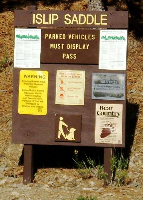
Islip Saddle
Islip Saddle Day Use Site (TH 6,680') - Islip Saddle Day Use Site ("Islip Saddle") lies on the Angeles Crest Highway (CA-2), at the junction of the northern terminus of the now closed Highway 39 (running up the front of the San Gabriel range from Azusa). It is virtually in the middle of the stretch of the CA-2 highway that runs between La Canada / Flintridge and Wrightwood / Cajon Pass, at mile marker 64.10. Islip Saddle has a large parking area on the northern side of the highway, directly across from the now gated and locked end of CA-39. There are restroom facilities and several trail opportunities from Islip Saddle.
The trail to Mount Williamson heads up from the very western edge of the parking lot, next to the restrooms. Be aware of the second trail option on the western end of the parking lot, heading down. This is the upper end of the South Fork Trail. From Islip Saddle, the PCT loops over Williamson's southern shoulder and back down to cross CA-2 at Kratka Ridge. On the crest of the shoulder, at GPS location 34.3660, -117.8602, an obvious use trail heads right (north-northeast), up the ridge to the summit. The trail from Islip Saddle is approximately five miles round trip.
Kratka Ridge TH (TH 6,680') - The Kratka Ridge trail head is located between Eagles Roost picnic area and the two tunnels on CA-2. It is approximately 1 1/2 miles west of Islip Saddle, and just over one half mile east of a large maintenance shed. It is located at mile marker 62.50, GPS co-ordinates 34.3620, -117.8703. From this spot, the PCT loops over Williamson's southern shoulder and back down to Islip Saddle. On the crest of the shoulder, at GPS location 34.3660, -117.8602, an obvious use trail heads left (north-northeast), up the ridge to the summit. This route to the summit is approximately five miles round trip.
South Fork Trail Head (TH 4,540') - The South Fork Trail runs southwest up a canyon beneath Mount Williamson's northeast ridge, loosely following the south fork of Big Rock Creek. To get to the South Fork Campground, take Highway 138 to Pearblossom. Turn south on Longview road. From Longview, turn east (left) on East Avenue 'W'/ Valyermo Rd. Follow Valyermo Rd for approximately 8 miles to Big Rock Creek Road. Stay on Big Rock Creek Road until the turn off for the South Fork Campground, which is approximately four miles from Valyermo Rd. Turn right, and head one more mile to the campground and parking lot. If this option is taken, the South Fork Trail itself is approximately 10 miles round trip.
Trip Highlights
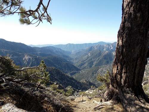 A view down Bear Canyon from the PCT on the southern flank of Mount Williamson, at the junction where the use trail heads up to the summit. The view is looking directly south from the junction. | 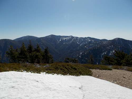 A view from the snow covered summit of Mount Williamson, looking southeast to Hawkins Ridge. In the background on the left side is Mount Baden-Powell, then in the center of the photo is Mount Burnham, Throop Peak, and Mount Hawkins, all located on Hawkins Ridge. In the foreground on the right side of the picture is Mount Islip. | 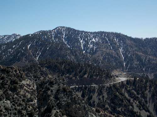 The northeast face of Mount Islip, as seen from the PCT trail on the way from Kratka Ridge to the southern shoulder of Mount Williamson. | 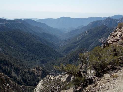 An alternate view down Bear Canyon, from the segment of the PCT heading up from Kratka Ridge to Mount Williamson. |
Red Tape
A National Forest Adventure Pass is required at the Islip Saddle, Kratka Ridge, and South Fork trail heads.
Alternately, if one pays the site fee to camp at the South Fork Campground, access to the trail head is free, and no Adventure Pass would be needed.
Currently, wood and charcoal fires are not allowed except in designated sites, in agency-provided campfire rings and stoves. Gas and petroleum jelly stoves are only allowed outside of designated sites with a valid California Campfire Permit. This permit is available for free and can be obtained from a number of sources, including the Bureau of Land Management, US Forest Service, National Park Service, or the California Department of Forestry and Fire Protection. Details can be found here, as well as in the external links section below.
When To Climb
Depending on which route you take, Mount Williamson may be climbed year round. Specifically:
Islip Saddle Day Use Site (TH 6,680') - Unless there has been recent and significant snow fall, the trail from Islip Saddle is usually clear, even in winter. There may be small pockets of snow in certain shaded areas, but they are generally not deep, and easily passable. Microspikes may be of use, but crampons and an ice ax would be rarely needed, as this portion of the trail receives high sun exposure and melts off quickly.
If connecting with Islip Saddle via the South Fork Trail from the South Fork Campground in Pearblossom, the South Fork Trail runs through high desert climate, and is rarely snow covered. The only time snow would be an issue is immediately after a large snow fall. Alternately, during the summer, the desert floor can easily be well over 100 degrees, so plan accordingly.
Kratka Ridge TH (TH 6,680') - The stretch of the PCT from the Angeles Crest Highway to the junction of the Islip Saddle route has lengthy stretches that are in constant shade, and may retain deep snow in areas for significant periods of time. This portion of the trail also contains areas with moderate exposure. While this portion of the trail is not long and is not technically difficult, it should not be underestimated. Depending on conditions, microspikes, crampons, and an ice ax may be very helpful.
SPECIAL NOTE:
During winter months, the Angeles Crest Highway (CA-2) closes in between Islip Saddle and Dawson Saddle due to extreme rockfall and avalanche danger. This means the only access to either mountain trail head is via the western end of the Angeles Crest Highway, in La Canada / Flintridge. Current highway conditions as provided by the California Dept of Transportation are located here.
Camping
There are a few good spots big and flat enough for tents on the south ridge, as well as in some spots along Pleasent View Ridge. There is also camping at the South Fork Campground at the beginning of the South Fork Trail. The trail between the South Fork Campground and Islip Saddle adds just over five miles each way to the hike.
Mountain Conditions
The new So Cal Snow Avalanche Center maintains up-to-date snow reports and avalanche conditions, as well as weather for the San Gabriel Range. It can be accessed here.
External Links
Angeles National Forest fire conditions and restrictions:http://www.fs.usda.gov/
Information on California Campfire Permits:
http://www.blm.gov/ca/st/en/info/iac/campfirepermits.html
Current Angeles Crest Highway conditions from CAL-DOT:
http://www.dot.ca.gov/
Devil's Punchbowl:
http://www.devils-punchbowl.com/index.html
Information on the C-119 crash into Pallett Mountain:
http://www.qnet.com/~carcomm/wreck25.htm