
-
 2741 Hits
-
 75.81% Score
-
 6 Votes
|
|
Mountain/Rock |
|---|---|
|
|
47.37562°N / 10.65101°E |
|
|
Hiking, Mountaineering |
|
|
Summer, Fall |
|
|
7766 ft / 2367 m |
|
|
Overview
The Lechtaler Alpen ranges end in the east with several small subgroups. One of these areas is called Ligfeistgruppe. This U-shaped mountain area has some interesting peaks and one huge advantage: all those peaks are one day outings. Many Lechtal peaks, however, require at least 1,5 days with an overnight stay in a mountain hut.

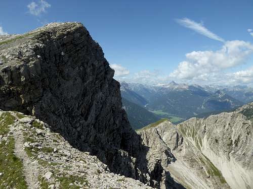
Knittelkarspitze is the highest peak of Ligfeistgruppe. You can summit Knittelkarspitze on a variety of routes: hiking routes, an easy via ferrata and an epic off-trail traverse among them. Marking the southernmost part of Ligfeistgruppe, Knittelkarspitze stands high above the Namlos valley with the eponymous village south of the summit. Immediate neighbours are Hintere Steinkarspitze to the east, an often visited summit and part of an easy via ferrata and Dürrekopfspitze to the west, an unknown and very rarely visited off-trail peak, part of an epic and difficult traverse of Ligfeist main range.


Due to the rather easy accessibility, Knittelkarspitze is not a lonely undertaking. Nevertheless I recommend a visit of this summit, together with the traverse of Hintere and Vordere Steinkarspitze on the “Reuttener Höhenweg” an easy and beautiful via ferrata. It will be a long but satisfying day. And the views from Knittelkarspitze into the Lechtal main ranges are awesome!
Getting There
Main trailheads for the Knittelkarspitze routes are:
- Rinnen
- Kelmen
- Namlos
All three villages are located at the Namlos valley which borders the south side of the Ligfeistgruppe.


By car:
- From Reutte or Arlberg direction use road number 198 to Stanzach. Turn on the “Berwang-Namloser Landesstraße” (signs for Namlos, Berwang) and proceed to one of the three above mentioned villages with the trailheads.
- Alternatively use road number 179 from Reutte to Bichlbach and turn on the “Berwang-Namloser Landesstraße” until you reach one of the three trailheads.
- From Innsbruck go on highway A 12 to the exit “Telfs”, proceed on road number 189 to Nassereith and on road number 179 to Fernpass, Lermoos and Bichlbach. Follow the signs to Berwang and Namlos to one of the three trailheads.
- Take highway A95 from Munich to its end and proceed on road number B2 and B23 / 187 to Lermoos. Turn on road number 179 to Bichlbach and go on like described above.
Rinnen trailhead: Leave the Landesstraße in front of the huge Hotel Thaneller. Follow the small road into the equally small village, this narrow road curves down into Rotlech valley. Go straight on until you reach a hikers parking area.
Kelmen trailhead: Follow the Landesstraße until you reach the road junction with the road to Kelmen. You can park at the road junction or alongside the road up to the tiny village of Kelmen.
Namlos trailhead: There is a small parking area immediately at a switchback of the Landesstraße at Namlos; or you enter the village and look for a possibility to park your car without disturbing the locals …


Public transportation:
Nearby railroad station is: Bichlbach
Bus number 151 goes to Rinnen. There is no public transportation to Kelmen or Namlos as far as I know.
Routes Overview
Trailhead Rinnen:
Take the forest road into Rotbach valley, turn on trail to Raaz Galtalpe hut, starting at the switchback of the forest road. From the alm hut follow the trail to a trail junction, turn left and immediately right (signposts), ascend Steinkar to the trail junction with Reuttener Höhenweg. Turn left (signposts for Knittelkarspitze), climb up to a col (some secured parts) and follow the southeast and east ridge to the summit.


Trailhead Kelmen:
Follow the road to the uppermost part of Kelmen village. Follow the forest road in some zigzags up the south slope of Kelmer Spitze. After the 7th switchback take the right hand trail and ascend to Kelmer Jöchl col. Traverse into Steinkar cirque to the trail junction above Raaz Galtalpe hut. Follow the sign “Knittelkarspitze" as described above.


Trailhead Namlos:
The Namlos route is a steep ascent on a trail, using the south slopes and the upper south ridge of Knittelkarspitze. I did that ascent many, many years ago and in those times there were no marks and the trail wasn´t maintained. More recent posts in the internet, however, tell that the trail has been reestablished and newly marked. On the summit there is even a sign for Namlos. So I think this route can be taken into account. It starts at the northern end of Namlos, ascends the woods to Schönjöchl and goes up the south ridge directly to the summit.


Traverse of the Ligfeist ridge:
The traverse starts at Weißenbach / Lechtal valley. The route goes up to Hallanderberg, Schartenberg and Schwarzhanskarspitze on forest roads and a marked trail. Between Schwarzhanskarspitze and Knittelkarspitze there are no trails. The ridge is in parts grade I, mostly walking and scrambling terrain with some bushwaking and then a grade II ascent to Knittelkarspitze in rather unsecure rock. You traverse Mittergrotzenspitze, Pleisjochspitze, Mitterkarspitze, Neualpspitze and Düssekopfspitze. From Knittelkarspitze you can proceed to the Steinkarspitzen, Galtjoch and Abendspitze.
The whole traverse requires two days and a bivvy somewhere between Schwarzhandkarspitze and Knittelkarspitze. Water resupply may be difficult!


Red Tape & Accommodation
Red Tape
No restrictions a s far as I know.

Accommodation
Mountain huts
Gear & Mountain Condition
Knittelkarspitze is a summer and autumn outing. Depending on the route our summit requires some rock scrambling in secured easy rocks.
The route from Namlos is steep with a narrow trail.
If you choose the traverse to Steinkarspitzen via Reuttener Höhenweg, bring self belay and a helmet for beginners. Reuttener Höhenweg is an easy via ferrata.


The epic traverse of the whole Ligfeist ridge is mainly an off-trail undertaking. The ascent to Knittelkarspitze via the west ridge from Dürrekopfspitze, the neighbour summit, is a grade II climb in unsecure rock.
Weather for Berwang:
Maps
Österreichische Karte, scale 1 : 50000
Number 2221, Imst, with UTM-grid, BEV – Bundesamt für Eich- und Vermessungswesen, Wien
Österreichische Karte, scale 1 : 25000
Number 2221-Ost, Erwald, with UTM-grid, BEV – Bundesamt für Eich- und Vermessungswesen, Wien, edition 2013


Wildflower Impressions
During summer Lechtal is a paradise for wildflowers. Even the eastern subgroups like Ligfeistgruppe does not make an exception.


