
-
 56503 Hits
-
 82.85% Score
-
 16 Votes
|
|
Mountain/Rock |
|---|---|
|
|
8.1076°S / 112.92145°E |
|
|
12060 ft / 3676 m |
|
|
Information on the trek to Mt. Sirung on Pantar Island
Overview
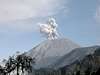
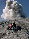
Gunung Semeru, also referred to as Mahameru (= "Great Mountain"), is the highest mountain on Java and one of the highest in Indonesia. It is a stratovolcano. It lies in Bromo-Tengger-Semeru National Park, in the province of East Java. Semeru is one of Indonesia's most active volcanoes. What stands out most about this mountain is the fact that it erupts periodically (and very reliably so). Every 20 minutes (August 2003) the volcano belches out a huge cloud of steam and smoke, sometimes interspersed with ash and stones. The scenery on the way is beautiful (the erupting volcano, the mountain savannah, the lake), and the views from the top are spectacular. You see the vast Sandsea caldera with other volcanoes, among them Bromo and Batok, and the sea. Semeru is a must for all mountaineers, hikers and nature lovers who happen to be in Indonesia. If you are flying from Denpasar to Surabaya, you can see Semeru, and you may see a horizontal chain of clouds stretching away from the peak. These clouds all have the same distance to each other due to the volcano's periodic activity. Many people climb this mountain, tourists and Indonesians alike. The steep-sided volcano rises abruptly to 3,676 m above coastal plains to the south. It is located at the southern end of a volcanic massif extending north to the 16-km-wide Tengger caldera. The Tengger caldera actually consists of five calderas, the most recent being the 9-km-wide Sandsea caldera, with its cluster of post-caldera cones. The youngest of these cones is Bromo, another of Indonesia's most active volcanoes, and the country's most frequently visited. View a video of an eruption here.
 |
 |
 |
 |
 |
Getting There
International airports: Denpasar, Jakarta Nearest domestic airport: Surabaya The starting point of the hike is the village of Ranupane. You can get there either via Malang and Tumpang or via Pasuruan/Probolinggo, Sukapura, Ngadisari, and Cemoro Lawang. You can take a microbus from Malang to Tumpang, and then a 4WD vehicle from Tumpang to Ranupane. But the latter of the above-mentioned routes is the more interesting because it leads across the 9-km-wide Sandsea caldera and passes Bromo, a post-caldera cinder cone. A dirt road leads across the flat bottom of the Sandsea caldera, up to Jemplang on its southern rim, and on to Ranupane. You have take a 4WD vehicle (unless you prefer to walk). There is accommodation in all the towns and villages mentioned above (including Ranupane).
 |
 |
 |
 |
Route
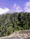
The trailhead is just outside Ranupane. You don't need a guide to find the way up the mountain: once you have left the village behind and are on the track, you can't miss the summit. Section 1: Ranupane - Lake Kumbolo (Ranu Kumbolo) There are two tracks leading from Ranupane to Lake Kumbolo. From the eastern track you get a spectacular view of Semeru (see signature photo). Eastern approach (via Watu Rejeng): Leaving the village of Ranupane (about 2,000 m), walk up the road to Lumajang for a few hundred meters and turn right just before the road starts going down. There is a signpost and also the rangers are very helpful to put you on the track. Follow the path up through mountain forest to Lake Kumbolo (2,390 m). It will take you about 3 hours to get there. Western approach: Info about the western track will be greatly appreciated. Section 2: Lake Kumbolo - Kalimati (base camp) This is an easy and beautiful hike through tussock savannah. It will take you another 3 hours. You can even walk up to Kalimati at night if, for instance, you chose to do Bromo in the morning, set out from Ranupane in the afternoon, and want to reach the base camp on the same day. In a moonlit night, this can be a rewarding experience. Section 3: Kalimati (base camp) - summit From Kalimati a path leads up through mountain forest to the treeline (about 2 hours). The final ascent, above the treeline, is a steep and somewhat strenuous walk over volcanic scree and sand, which will take you another 1 to 2 hours. The top is a rather big, flat area. The present-day crater is a bit further on, below the summit, to the south. From the top, you cannot look inside the crater. For your own safety, stay clear of the crater rim. You can do the hike from Ranupane and back in 2 days / 1 night.
 |
 |
 |
 |
 |
 |
Camping
There are four camping areas. First, at Ranukumbolo, a beautiful lake, where you can find the last water resources on the route. Second, at Kalimati, which is situated at the borderline between a tussock savannah plain and the steep ascent through mountain forest up the actual volcano cone. There is a spring at a distance away from Kalimati. Third and fourth, at Arcopodo and Killik further up in the forest, where you will find several flat areas.
 |
 |
 |
 |
Red Tape
You must report to the ranger's office at Ranupane, where you are registered and have to pay an entrance fee of 20,000 IDR (= €1.70/$2.10). At the moment (June 2012) only permits for sections 1 and 2 (up to Kalimati) are being issued. You are not supposed to go any further, but everybody seems to climb the top. You are supposed to bring a health certificate, but if you don't have one, the rangers don't insist on it. Bring a copy of your passport. You can also hire equipment (tents, mats, sleeping bags, jackets) at the ranger's office.
When To Climb
April - November (but people also climb it in December)
 |
Mountain Conditions
For volcanic activity check the reports published in the Global Volcanism Program by the National Museum of Natural History, Smithsonian Institution - Semeru (there are photographs as well). Weather
 |
David Donaldson - Jul 20, 2002 7:45 pm - Hasn't voted
Untitled CommentThe track from Ranu Pane to Ranu Kumbolo is about 10km and winds around the mountainside gaining a few hundred meters before dropping down to Ranu Kumbolo from the North. There are a few trees accross the track but otherwise quite easy walking.
Be difficult to get lost on this stage!
June 2002
David Donaldson - Jul 20, 2002 7:54 pm - Hasn't voted
Untitled CommentYou can rent tents and a guide porter from the losman in Ranupane. It is reccomended you take a guide and someone to carry the additional water and food. It can get confusing up high in dense cloud.
You can get from Ranu Pane to Arcopodo in one day but unless you are fit you may not want to struggle to the summit the next morning! Altitude also makes you a bit lethargic if you have come from sea level.
Ranu Pane losman has some of the coldest water in the world!!
David Donaldson - Sep 6, 2002 5:36 pm - Hasn't voted
Untitled CommentFollow the link to read all about it....
http://www.post-gazette.com/healthscience/20000827volcano1.asp
David Donaldson - Oct 9, 2004 12:02 am - Hasn't voted
Untitled CommentThe normal 10km walk through the forest from Punu pane to Ranu Kumbolo gets a bit stale after 4 or 5 times. We had heard about an alternate route from Ranu Kumbolo heading over the hills and straight down into Ranupani. Youy need a guide on the last bit because it is difficult navigating thru the fields back to Ranupani. Time is about 30 minutes quicker than circuitous route and the views are just amazing.
From Ranu Kumbolo head north around the lake but follow the trail left into the tussock valley and not right and up around the lake.
The trail is clear and turns north to the end of the valley from whence it proceeds up the side and on to a pass. A bit steep and slippery but worth the effort.
when you get to the pass head up the ridge a few meters for fantastic views of semeru. from here the trail descends relentlessly into ranupani. bring your best set of knees. It arrives in Ranupani slightly to the North of the town and you miss out on the 3km roadwalk on the normal route. We were on our second or third beer at Pak tasrips guest house before the others began trooping in
Anuj K - Nov 2, 2014 12:40 am - Hasn't voted
GoPro video of Semeru with English captionsHere's a concise video journal of the entire hike, taken with a GoPro. Gives a good view of the entire route and the top with English captions : http://youtu.be/y-_azPBMd9g
gagarych - Jun 19, 2015 8:10 am - Hasn't voted
Western ApproachGPS track of western approach and new trail from Kalimati to summit: http://gaziga.com/semeru/semeru.kml Track to water source from Kalimati basecamp: http://gaziga.com/semeru/kalimati-water.kml Photos and report in my blog (in russian): http://gaziga.com/semeru/ Feel free to comment and ask any questions :)
bisbj - Oct 2, 2015 2:26 am - Hasn't voted
Great hike!A GPS track and some information can be found here: http://www.wikiloc.com/wikiloc/view.do?id=10791678