
-
 19817 Hits
-
 90.48% Score
-
 32 Votes
|
|
Mountain/Rock |
|---|---|
|
|
46.49984°N / 14.78047°E |
|
|
Hiking, Via Ferrata, Skiing |
|
|
Spring, Summer, Fall, Winter |
|
|
6971 ft / 2125 m |
|
|
What's New On This Page?
> Jan 22nd, 2019: Design corrections.
> October 2nd, 2005 - Initial page setup.
Overview
Remark: When reading Slovenian words on maps or in books, you will find special characters for ch, sh, and zh. They are written with c, s and z with a caron - little v above them.
General
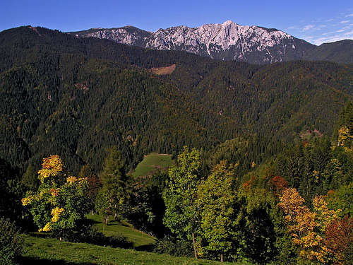
Peca / Petzen (pronounced: Petza) is the last high mountain in the Karawanks range, going towards the East. Actually, if the whole long arc of European Alps would not have a strange tail towards the NE, towards Vienna, the whole Alps would end here, where high mountains blend into forehills and finally lower down on the Panonia plane. To a certain degree, Peca is also a cult mountain, at least for Slovenian people. I'll tel the fairy tale later.
In Wetterstein limestone there were once rich deposits of led and zinc, so big mines were all over the mountain. Today, they are mostly closed and arranged for tourist visit.
Geography
From all sides Peca is seen as a broad massif. If there were no forrest roads, ascents to the summit would be high and long, as town and villages around the mountain are lying some 1500 m lower.
The whole massif is lying south of Drava / Drau river, roughly at the place, where this river crosses the Austrian-Slovenian border. But the massif is divided from the surrounding mountains by several creeks and saddles. When saying that Karawanks mountains end here, we were not entirely correct. Actually from Peca the last outposts are stretching towards the East, so Uršlja gora is considered to be the last high peak (1696 m) on the East.
The more than 3 km long Peca summit ridge consists of several almost equally high summits. On the East, the highest summit stands, Kordeževa glava / Kordeschkopf, 2125 m. Towards the NW there is then Končnikov vrh / Knieps, 2109 m, then Bistriška špica / Feistritzer Spitze, 2114 m and finally Veška kopa / Wackendorfer Spitze, 2074 m. All these summits are accessable by easy marked paths.
On all sides of the massif rocky crags and walls can be seen. Most of them are on higher regions, but vertical crags and rock towers can be found also in lower, forrested areas. Through these rocky regions, however always some quite easy passages can be found. Towards the north, in high regions, several dry, rubble valleys are descending from the summit ridge. They are divided by side ridges which offer good passages, but their walls can be very steep, wild, and also a 100 m or 200 m high. The northernmost such valley is called Schagerkar, SE of it is Deutschmannkar. Then comes the broad basin of Obere Krischa, bordered by two side ridges which both host easy marked paths (and the eastern one also ski terrains). Further to the E comes Trebnikkar and then finally Griwankar, the easternmost valley.
The southern side of Peca is more compact, but below the highest summit there are also steep rock walls and towers. On the western side, there is a steeper, craggy area above the valley of Globasnitzbach.
What To Do There?
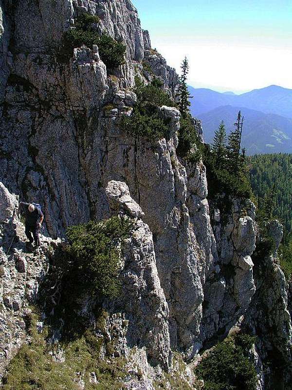
Peca is equally a hiking, climbing, skiing and mountain-biking mountain. Many marked paths allow us to ascend its summits comfortably, but utilizing a few of mountain's rocky faces, there are also two short ferratas for those, who like to stretch their limbs a bit more. On the northern slopes of the mountain there is an ordinary ski resort, but the summits are also excellent for tour skiing. Mountain bikers can use many high reaching mountain roads, but nowadays thousands of them are using the Austrian cable way, which brings them and their tools on the altitude of 1700 m. From there, at least two bike trails are descending almost 1200 m down. Tourists can bike even through the tunnels of ex led mines.
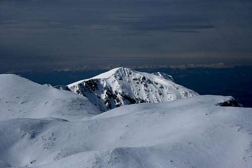
Summit Panorama
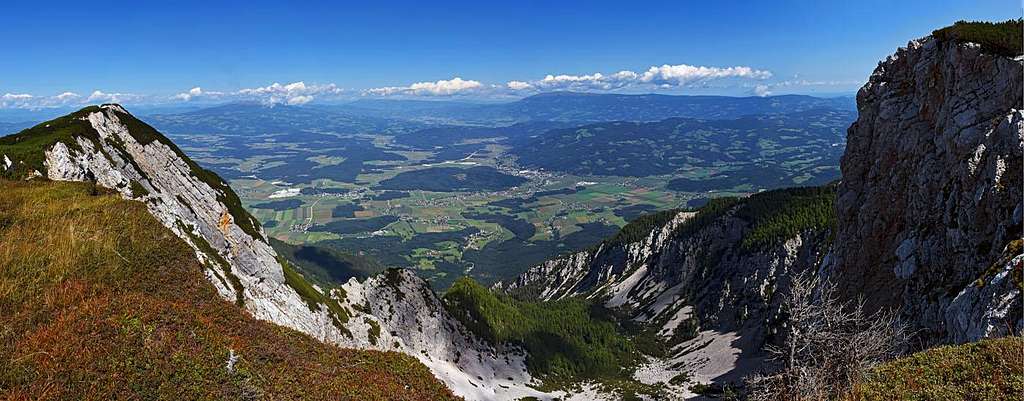
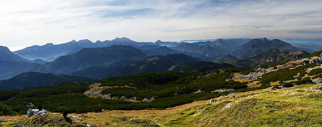

The view from Peca's summit is very broad. Towards the SW, Kamnik and Savinja Alps are beautifully seen, right of them the long range of Karawanks is stretching. Behind these, Julian Alps with Triglav are usually nicely seen. In a clear day, the horizon on the Austrian side is packed with mountains - from Hohe Tauern, to the whole range of Niedere Tauern on the North, and in front of them Lavanttal Alps on the North and North-east. Towards the south, almost the whole hilly Slovenia can be seen.
 |
 |
 |
Getting There
For the broader overview see the Karavanke/Karawanken group page!
| See full screen! Red: marked paths, CornFlowerBlue: ski tours, DarkSlateBlue: paths/cart-roads, useful for skiing. |
|
Routes Overview
Here is only the list of hiking trails:
N approach (from Siebenhuetten, reched by cable-car or on foot)
- Siebenhuetten (hut) - Kordeževa glava / Kordeschkopf. Easy hike (T2), 1 h 45 min. From the upper station on Knips saddle, 2012 m, and towards the E to the summit.
- Siebenhuetten (hut) - Feistritzer Spitze / Bistriška špica. Easy hike (T2), 3 h 45 min for the whole round tour. From the upper station on Knips saddle, 2012 m, by the main ridge towards the NW to the summit and back to the upper station.
- Walter Mory Klettersteig. Medium difficulty ferrata (C/D), exposed, helmet and self-protection set needed. You can start the tour either by the lower station of cable-car and hike up to the ferrata entry, or descend to the entry from the upper station, where the ferrata ends.
W approach (from Luschaalm / Luža alpine meadow)
- Luža / Luschaalm - Feistritzer Spitze hike up. Easy hike (T2), 2 h 15 min. Over meadows and woods towards the NE on the summit of Bistriška špica / Feistritzer Spitze.
- Luža / Luschaalm - Feistritzer Spitze W round tour. Easy ascent by the normal hike up, then a quite demanding (T4/T3) descent by a faint hunters' path. Some 6 hours for the whole round tour.
S approach (from Fajmut farm)
- From Fajmut farm some 1100 m, you can hike by a marked path towards the NE and reach Dom na Peci (hut), where you join the E approaches. But the direct ascent goes northwards and reaches over steep slopes the Knips saddle and from there the main summit. 3 h. Marked.
E approach (from the parking place at the end of the road)
- Normal E hike up on Kordeževa glava / Kordeschkopf. Easy hike up, 2 h 15 min. You first reach Dom na Peci (hut) in less than 45 min, and from there continue first towards the N, then towards the NW.
- Eastern ferrata on Kordeževa glava / Kordeschkopf. Medium difficult ferrata (C), 2 h 15 min. You first reach Dom na Peci (hut) in less than 45 min, and from there continue to the saddle below Mala Peca, above which you turn left in the ferrata, which brings you directly on the summit.
Rock climbing. In the southern rocks of the highest summit there are several short routes up to UIAA V degree. The approach for all of them goes from Dom na Peci to the saddle below Mala Peca and further left below rocky towers.
Tour skiing. Below is a quite comprehensive list of all ski tours in the broader Peca massif. Alpinistic ski tours (more demanding) are excluded.
| No. | Mountain/ Ski tour |
Altitude gain |
Ascent hours |
Grade | Description / comments |
| 1 | Bistriška špica, 2113 m, from/to Luža meadow |
875 m | 3:00 | F+ | It's one of the most popular and most meautiful ski tours in Karawanks. Despite a remote area, locals usually make a ski track. From the Riepl inn we go on the Luža meadow, from there towards the NE on the highest point (following the summer marked path). |
| 2 | Bistriška špica, 2113 m, north-west ridge greben |
1600 m | 5:00 | F | All the way down to Veška planina (meadow) a very nice ski tour, but from there it's still far down to the valley (by a road) and then even further up to the Luža meadow, if you had started the tour on Bistriška šica there. |
| 3 | Bistriška špica, 2113 m, Kumrov žleb (ravine) |
1000 m | 3:30 | PD | It's quite a popular ski descent by a typical Peca's ravine. By the side ridge of Peca we ski down towards the SW, then usually the return to our car awaits us (to the Luža or elsewhere). |
| 4 | Križnik, 2109 m, Kumrov žleb (ravine) |
1000 m | 3:30 | PD | We for example ascend the summit of Križnik from the Končnik farm, over the Preval and further up following the summer path. From the summit we ski down by the Kumrov žleb. |
| 5 | Končnikov vrh, 2109 m, Northern ski tour |
400 m | 1:15 | F+ | It's one of the many ski tour from the ordinary ski terrains of Peca. From the upper cable way station we walk up on the Knipsovo sedlo (saddle) and to the right on the nearby summit. |
| 6 | Velika glava, 2077 m, Northern ski tour |
400 m | 1:30 | F+ | Also this summit is quickly and easily reachable from the ski terrains of Peca. From the upper cable way station we walk up on the Knipsovo sedlo (saddle) and to the left on the summit. |
| 7 | Kordeževa glava, 2126 m, Northern ski tour |
500 m | 1:45 | F+ | Also the highest summit of Peca is easily reachable from the ski terrains. From the upper cable way station we walk up on the Knips saddle and then to the left in 30 min on the summit. |
| 8 | Kordeževa glava, 2126 m, N ski tour (Griwankar) |
1200 m | 4:00 | PD- | The Griwankar ravine is the continuation of Poljska jama towards the NE. The ski descent by the upper part of the ravine is very beautiful, then the traverse on the E slopes of Peca massif (if we want to ski down towards the Mežica town) is a bit more unpleasant. |
| 9 | Kordeževa glava, 2126 m, Eastern ski tour |
1100 m | 4:00 | F+ | The ascent by the road till the Dom pod Peco (hut) can be very long if the road is not cleaned in higher regions. From the hut we continue up by the normal summer route. The ski descent towards the east is then in good conditions very nice and also very long (over the Riška gora). |
F means easy (facile), PD means little demanding (peau difficile).
You can see a detailed map (1:50.000) on-line also on: http://www.austrianmap.at/. But the above embedded map can be more useful.
When To Climb
Any time of the season.
|
|
Huts and Camping
As all ascents are rather short, there's no need to camp on the mountain.
Dom na Peci, 1665 m. Opened from June till October (outside this periods on weekends). 81+19 beds, tel.: +386 (2) 82 38 406, mobile: +386 (41) 324 817. Near the hut (10 minutes away) there's a cave with King Matjaz's statue.
Siebenhuetten, 1692 m. Private, opened June to September and in spring, depending on snow conditions. 20+10 Beds, tel.: 04235/5116, 0664/3522527.
The Tale of Kralj Matjaz
King Matjaž (pronounced: Matiazh) was good and powerful, but didn't know what the salt was. When some day an old man put some salt into his dishes he found it delicious and asked the old man to show him where to get it. The old man was willing to do it but his price was half of Matjaz's kingdom. After the agreement was made, the old man showed the king a hill, made of salt only. But the king realised that that hill belonged to his kingdom anyway, so he refused to give the old man what they agreed and challenged him on a duel instead.
King Matjaž came with his whole army and the old man came alone. But when the fight was to start the skies became dark, a huge storm occured and King Matjaž realised that he challenged the God himself. To save his life he cried: "Mountains cover me and my army!" and so it happened.
He still sleeps there, in a cave below the summit of Peca, behind a stone table. It is to be believed that when his beard will grow enough to encircle nine times his table, the World will see hard times. But King Matjaž will awake and help people. A new golden age will begin.