
-
 22939 Hits
-
 84.82% Score
-
 19 Votes
|
|
Mountain/Rock |
|---|---|
|
|
44.12398°N / 115.04544°W |
|
|
Boise |
|
|
Hiking, Mountaineering, Mixed, Scrambling |
|
|
Summer, Fall |
|
|
10297 ft / 3139 m |
|
|
Overview
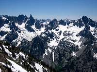
Baron Peak is one of the more accessible peaks in this part of the SawtoothRange for hikers and scramblers. It's Class 3 slopes provide exceptional viewsof the surrounding terrain including the Monte Verita Ridge, where many Class 5 towers and peaks are situated. Nearby WarbonnetPeak, BaronSpire, TohobitPeak, and GrandjeanPeak provide a stunning foreground to the rest of the range while looking south from the Baron Peak summit. The trail portion of the approach involves 4.5 miles of gradually ascending terrain, while the lower Moolack Creek scramble requires careful traversing of the edge of the creek to avoid heinous bush-whacking. Once into the upper Moolack Creek talus field, the terrain changes to a typical alpine environment with little vegetation, plenty of scree,large blocks of rocks and lingering snow-fields. The west ridge often has the elusive mountain goat and the summit contains a summit canister placed by Greg Parker with a handful of names in the log. An impressive goldbenchmark adorns the summit, placed in 1928.
In 1989 the Sawtooth climbing pioneer Louis Stur fell and died on Baron Peak while exploring a new route. Stur is responsible for pioneering many of the moderate rock climbs in the range including the SturChimney on Mt.Heyburn. In it's day, Louis Stur's routes were anything but moderate; they were considered extreme. While much of Baron Peak contains some of the less vertical routes in the area, the rock is incredibly loose in spots and the undocumented north side is nearly vertical. Nearby Moolack Mtn is actually taller than Baron Peak and contains many challenging routes, yet there is no documentation beyond the Tom Lopez mention. This neighboring peak is a prime candidate for a name and some exploration.
Routes

Baron Peak Routes.
Moolack Creek Approach / West Face: Follow the Moolack Creek drainage from where it crosses the Baron Creek Trail, stay on the west side ofthe creek until it splits. Follow the ridge that divides the two forks of thecreek until about 7600 feet where you'll cross the creek and head east into theupper bowl, just west of the peak. Either access the saddle that separates Moolack Mtn from Baron Peak, or ascend the ridge just west of Baron peak. Look fornarrow slot on the west face. Follow this narrow slot up until it becomes aClass 3 ledge system.
7.5 miles and 5764 feet elevation gain (one-way)
West Ridge Approach / SE Face: Just past the Moolack Creekcrossing, leave the trail and ascend the steep slope staying near the edge ofthe trees and open brush. Set a course toward Point 8962, but be sure to stayjust south of this point. If you end up northwest of this point you'll getcliffed. From near 8962 follow the ridge toward the west face of BaronPeak. Traverse south of the summit until you come to a prominent rugged SEridgeline. Follow this steep Class 2-3 slope to the summit.
5.9 miles and 5527 feet elevation gain (one-way)
Ascending nearby Peak 10330 in the same day is possible. After Baron peak,descend to the prominent saddle north of Baron Peak. You'll need to bypassa vertical tower on the way up to Moolack Mtn by going just west of this tower and followthe steep southern slopes.
Activity Matrix

| Activity | Rating 1-10 | Required Experience |
| Rock Climbing | p | advanced |
| Alpine Climbing | 7 | intermediate |
| Hiking / Scrambling | 8 | intermediate |
| Trail Running | 7 | beginner |
| Mtn Biking | 0 | n/a |
Key:
p=potential, but unknown
Getting There

Road Approach
Follow ID-21 to the Grandjean turnoff (signed). Followthis dirt road for seven miles to the trailhead. There is camping and limitedsupplies nearby.
Trail Approach
From the Grandjean trailhead, follow the trail alongthe South Fork of the Payette River until it forks and follow the Baron CreekTrail. After 3.5 miles, cross the creek utilizing a large log. Stay in theSouth Fork of baron Creek with views of Baron Peak and Tohobit Peak. Leavethe trail after another mile near the Moolack Creek crossing.