
|
|
Mountain/Rock |
|---|---|
|
|
47.41010°N / 120.8415°W |
|
|
Kittitas |
|
|
7036 ft / 2145 m |
|
|
Overview
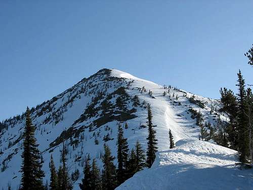
The summit of Earl Peak from the north (10/5/08)
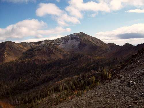
Earl Peak is the formidable mass which rightfully impresses just about any driver making their way up the North Fork Teanaway River valley. Standing roughly 4600 feet above its initial viewpoint from the drive in, Earl Peak makes any summer hiker giddy to seek its striking summit. Jagged and rocky, yet grazed on its lower flanks with alpine meadow vegitation, Earl makes a wonderful and not terribly stressful summer outing. That is, if you are the hiker type and enjoy outings in pleasant weather and without self-arrest and avalanche awareness skills. Tha being said Earl Peak can be very hot during the summer months so it is best to hit this mountain in September when the weather in the Teanaway starts to cool down.
Earl Peak as seen from the South Ridge; late April 2006. Photo copyright Jim Kuresman, 2006.
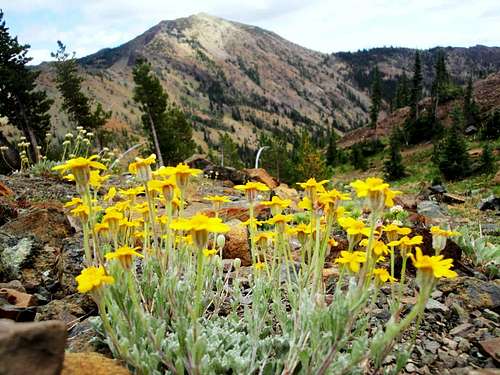
If you're a more hearty year-round mountaineer, Earl makes a great Spring or Fall climb, and is feasible even in winter. If done before April though this can be a very long trip due to the road being closed for the season. It is one of the higher peaks in the Wenatchee Mountains, and views from the summit span everything from Rainier to an in-your-face view of nearby Mt. Stuart. A small spring resides on the south face of Earl, and its access routes present the summer climber with great views of local wildflowers and other fauna. Regardless of the season, Earl is a great climb, and its prominence makes it well worth the time.
Earl Peak seen from the ridge connecting Judi's and Mary's Peaks.
Getting There
Earl Peak is located Just off of the North Fork Teanaway River, North of Cle Elum, WA.From I-90 East or West, take exit 85. From here, get on Highway 970 heading East. Follow 970 for about six miles. Here, you will come to an intersection with Teanaway Rd., turn left. Keep following the Teanway Road, which will eventually turn into N. Fork Teanaway Road. Once you reach the "29 Pines" campground, the road will become gravel and split into two forks... take the right fork. You are now on Road 9737. After about a mile of gravel, Road 9703 will be to your right. Stay on Road 9737 (left). Follow for another two miles or so, then take a right onto Road 112. As of my last trip there, Road 112 was a one lane, fairly poor-shape gravel road. Once you reach the end of Road 112, you will be at the Beverly Turnpike Trail #1391 trailhead, elevation 3600 feet.
Red Tape
Northwest Forest Pass Required at trailhead. Even though Earl Peak is just shy of the Alpine Lakes Wilderness boundary, it always helps to sign in at the trailhead to help out with trail usage figures and to give a record of your travels in case you get lost. Earl Peak is located in the Wenatchee National Forest, so appropriate regulations must be followed. For more information, visit http://www.fs.fed.us/r6/wenatchee>this site.Camping
This is a dayhike, however camping opportunities abound in the area. All camping regulations of the Wenatchee National Forest must be met, however remember that Earl Peak is NOT in the Alpine Lakes Wilderness so none of those regulations apply. Earl's south ridge would make a nice campsite, as well as Bean Creek. In addition, the Beverly Campground is very close to the trailhead. The De Roux and 29 Pines campgrounds are also in the area.Maps
USGS Enchantment Lakes Quadrant: 1:24000 scaleGreen Trails #209 - Mount Stuart: 1:69500 scale
Note: the Green Trails map makes a great road map for the drive in, although it doesn't cover the section from I-90 to the Teanaway Road.
External Links
Recent Trip Report on Earl PeakSpring Trip Report to Earl Peak
Early Spring Earl Trip Report