
-
 35437 Hits
-
 75.8% Score
-
 6 Votes
|
|
Mountain/Rock |
|---|---|
|
|
34.37650°N / 118.1775°W |
|
|
Los Angeles |
|
|
Hiking |
|
|
6520 ft / 1987 m |
|
|
Overview
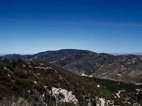
Mount Gleason is the western end of the San Gabriel Mountain high country and is the fifth most prominent peak in the San Gabriels with a prominence value of P1600. Mount Gleason is on the Sierra Club's Hundred Peaks List.
There are many ways to reach this conifer covered summit. It is a virtual drive up from Mount Gleason Road or can be a hike of varying lengths from the Pacific Crest Trail that runs the length of its spine. A good long route up Gleason would be to take the Pacific Crest Trail from Mill Creek Summit, a 16+ mile hike.
I have included three other shorter routes, including one that takes you to Messenger Peak, the most western six thousand foot point in the range. Gleason is a good peak to do in combinations with Fox Mountain, Iron Mountain #2, Condor Peak, and its little sister Messenger Peak.
Route 1 Pacific Crest Trail from the East

Getting there:
Take the I-210 freeway to La Canada andtake the Angeles Crest Highway (SR-2). Drive north SR-2 for 9.5 miles to a junction with Angeles Forest Highway. Turn left go 14.2 miles to Mill Creek Summit. On the left is the entrance for Mount Gleason Road. Continue on Mount Gleason road for about 7 plus miles. As you leave behind the dirt section of Mount Gleason Road and return to asphalt find a turnout to park. Just on the northside of the road is the Pacific Crest Trail. Take the PCT for about two miles reaching the ridge just north of Gleason. Take the ridge pass bump 6502 feet, where the Hundred Peaks register is, and continue to the true open and broad summit of Gleason.
Roundtrip is around 4 miles with around 1200 feet of gain.
Route 2 Messenger Flats & Messenger Peak

Getting there:
Take the I-210 freeway to La Canada and take the Angeles Crest Highway (SR-2). Drive north SR-2 for 9.5 miles to a junction with Angeles Forest Highway. Turn left go 14.2 miles to Mill Creek Summit. On the left is Mount Gleason Road 3N17, take it for almost nine miles on mostly paved rough road. As you pass the large microwave towers continue about a .5 miles to a junction. Take the right fork for about a miles down to Messenger Flats Campground. Park just pass the campground at a turnout at the base of Messenger Peak.
Route:
Messenger Peak is a quick jaunt up the firebreak above the parking area. It has great views of the badlands connecting the San Gabriels to the Sierra Pelona Mountains. From the parking area take the Pacific Crest Trail just north of the road. Take the trail as it ascends the west slope of Gleason through the dense stand of conifers. At the summit ridge of Gleason turn south and walk up the road pass bump 6502 feet with the register, continue a little pass this to the true summit of Gleason.
Roundtrip is about 3 miles with about 800 feet of gain.
Route 3 Summit Turnout

Getting there:
Take the I-210 freeway to La Canada and take the Angeles Crest Highway (SR-2). Drive north SR-2 for 9.5 miles to a junction with Angeles Forest Highway. Turn left go 14.2 miles to Mill Creek Summit. On the left is Mount Gleason Road 3N17, take it for almost nine miles on mostly paved rough road. As you pass the large microwave towers turn right and park at the gated entrance.
Route:
Hike past the gate and up to the open summit. Continue past the summit along the dirt road to bump 6502 feet to locate the Hundred Peaks Summit register.
Roundtrip is over .5 miles with about 200 feet of gain.
Red Tape
You will need an Adventure Pass for parking at the turnout.
Camping
For camping information and current conditions in Angeles National Forest. Here are three of the nearest campgrounds, all of which would be great staging places for peakbagging in the western San Gabriels:
1. Lightning Point Campground, on Mount Gleason
2. Messenger Flats Campground, on Mount Gleason
3. Monte Cristo Campground, off of Angeles Forest Highway but south of Mill Creek Summit
External Links
Mount Gleason is on the Hundred Peaks List.
Check out the California Mountain Atlas for more prominence information.