
-
 21610 Hits
-
 93.35% Score
-
 42 Votes
|
|
Mountain/Rock |
|---|---|
|
|
43.78740°N / 110.8138°W |
|
|
Hiking, Mountaineering, Scrambling |
|
|
Summer |
|
|
11270 ft / 3435 m |
|
|
Overview

Not surprisingly, the famous technical peaks such as the Grand Teton, Mount Owen, and Mount Moran get most of the climbing attention in Grand Teton National Park. And if you prefer scrambling to roping up and day trips to overnighters, there’s not much for you in this world-famous range unless you’re up to day climbs involving 5000-6000’ of elevation gain. But if you’re in good shape and can handle 16-19 trail miles plus an extra 1-1.5 climbing miles, with about 4600’ of elevation gain in all, here’s something for you. You can make the climb itself anywhere from Class 2 to Class 5, with the possibility of a snow climb and/or glissade as well. And you will have one of the finest views available in the park; most such views in the Tetons require roping up to get them, but this one doesn’t.
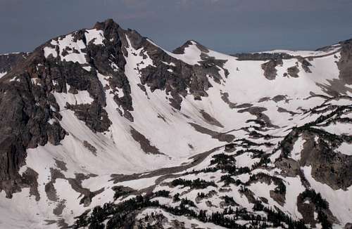
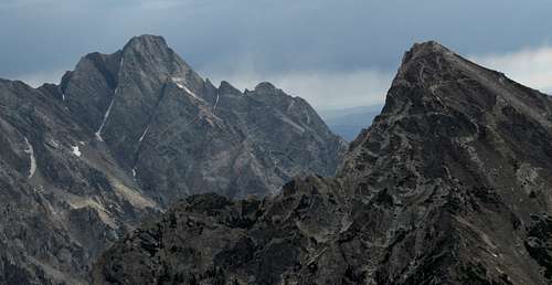
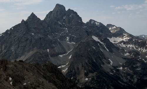
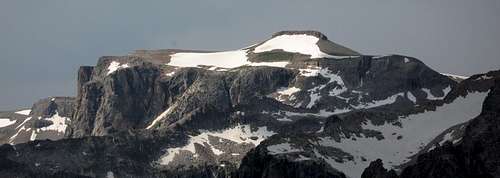
This peak is southeast of 10,700’ Paintbrush Divide and is visible from the divide and from the Cascade Canyon and Paintbrush Canyon approaches to the divide. Although it has more than 300’ of prominence from its defining saddles (actually, about 600’ from both Paintbrush Divide and the peak's southeastern saddle) and is the third-highest summit on the ridge system containing the named peaks Mount St. John, the Jaw, and Rockchuck Peak (it is actually higher than the third), it is not even marked on some topo maps with an exact elevation even though some lower summits are. Its elevation given on the USGS Mount Moran quad is 11,270’.
Not even the climbing rangers at the Jenny Lake Ranger Station know of a name for this peak, but they do know of it. One referred to it as “a nice little summit” for its views up and down the range. However, in Guide to the Wyoming Mountains and Wilderness Areas by Orrin and Lorraine Bonney, there is a suggested name of "Mt. Fryxell." Fritiof Fryxell was the first ranger for Grand Teton National Park and the first to write about the climbing there, and he (this is according to the Bonney guide) made more major first ascents in the Tetons than anyone else (the Bonneys put it at 14). The first known ascent of this peak was in 1955, by Leigh Ortenburger.
So if you’re up for a long day with a little bit of invigorating climbing easily manageable without technical gear and want a little taste of the best of the Tetons, come on out to this peak. Although the summit views don’t reveal much more than the views on the upper portions of the Cascade-Paintbrush Canyons loop do, they do what the trail views cannot, even from Paintbrush Divide-- they show all of it at once. Most rewarding is looking south at the skyscraping Grand and its neighbors and then making a 180-degree turn to enjoy an unforgettable perspective of Mount Moran, Thor Peak, and Mount Woodring.
Route Information
Paintbrush Divide

Climbing Conditions

Climbing Conditions

Climbing Conditions

Climbing Conditions
The route I did and which I recommend, because of the variety of nearly-nonstop spectacular scenery, is detailed in this section. Start from the Leigh Lake Trailhead, which is at the end of a spur off the Teton Park Road just before the start of the one-way road past Jenny Lake. From this trailhead, it is 7.9 miles to Paintbrush Divide, with most of the 4000’ of elevation gain occurring after the first 2.5 miles. The entire Cascade-Paintbrush loop is 19.2 miles, but one can just hike to Paintbrush Divide and back, keeping the trail part of this route at just under 16 miles. A very early start, sometime within an hour of dawn, will mean that you will see few or no other people as you hike up to Paintbrush Divide. It will be a very different story as you hike down Paintbrush or Cascade Canyon in the late morning or the afternoon.
The basics: app. 19 hiking miles, 1.5 climbing miles (RT), 4000’ elevation gain on trails and about 600’ off, Class 2-5 depending on exact route followed. 7.9 miles/4000' to Paintbrush Divide, 11.3 miles back via Cascade Canyon.
Ideas of time commitments: I started at 6 A.M. and reached Paintbrush Divide by 9. The climb took 45 minutes; the descent, thanks to a glissade, took under 30. I did the entire described loop and reached my car at 2 P.M., a total of 8 hours for about 20.5 miles and 4600’. Most people, though, take 10-12 hours just for the loop, so plan accordingly. Know your pace and stamina and choose your start time based on them. I recommend planning 30 minutes per trail mile and 2 hours RT for the climbing portion. If all this is too much for you for a day trip, look into getting a backcountry camping permit instead. Either way, this is one of the best outings that hikers and scramblers could ever have.
Up Paintbrush Canyon
For a flat mile, the trail goes along the shores of String Lake until it crosses the outlet of Leigh Lake and begins to climb at a moderate grade to the Paintbrush Canyon Trail at 1.6 miles from the trailhead. The trail stays mostly gentle until it enters the Lower Paintbrush camping zone. Views will start opening up, and sightings of elk and moose are common. Wildflowers are everywhere. Not shocking is the observation that paintbrush grows in abundance, but the canyon also teems with columbines, monkeyflowers, and many other species.
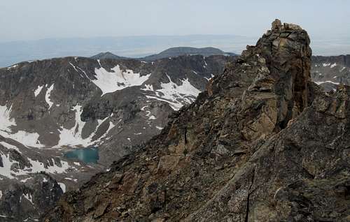
At about 5.7 miles, the trail splits. The left fork keeps climbing up the canyon, but the right fork leads for 0.5 miles to Holly Lake, which is at 9400’, close to timberline, and right beneath Mount Woodring. It is worth going by the lake, and the right fork, although a little more popular, is also a little shorter than the left one.
The trails rejoin at about 9700’, and Paintbrush Divide is a little over a mile away. The canyon opens up, and though you are not truly above treeline yet, you will see only small stands of trees now, and although the high, bare ridges and peaks dominate the scenery, take time to notice the appearance and abundance of alpine wildflowers. The last few switchbacks to the divide are the steepest part of the trail, and there will probably be snowbanks to cross. Rangers often issue an ice-axe advisory through mid-July, so check on conditions the day before by stopping at a ranger station (the closest one is at Jenny Lake, and the rangers there are the park’s most knowledgeable about trail and climbing conditions).
To the Top
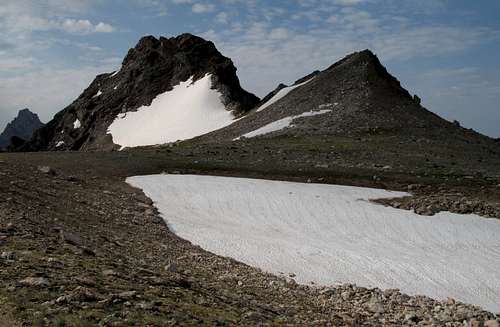
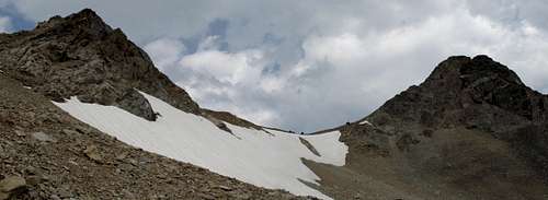
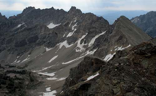
Seen from Paintbrush Divide, Mount Fryxell rules the skyline to the east. Notice the large snowfield on its northern face and at its base and examine the possibilities for climbing.#1— The easiest way, in technical terms, is to descend to the bottom of the snowfield and then ascend along its and the mountain’s left sides. This is a route on loose talus and is easily kept at Class 2. If you like scrambling a lot more than talus slogs, save this route for the descent.
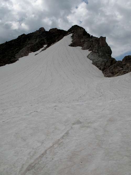
#2—If you remembered your ice axe, climb the snowfield (about 300 vertical feet, moderate in the middle, steep near the top) to its upper end and then follow Class 2 or 3 rock to the summit. I used this as my descent route. Warning: the top of the snowfield is steep, and a glissade from it will get you going very fast very quickly, so make sure you really know how to use an ice axe. Don’t use this spot as a place to learn; the result may be sailing off a cliff into Upper Paintbrush Canyon.
#3—This is the way I climbed up. I chose it because the climbing looked more challenging and fun that way. It was both. Approach the right side of the mountain by crossing boulders and talus to the right of the snowfield. An advantage of this route, even though it is harder than #1, is that you do not have to give back and then regain any elevation. Once at the little saddle between Mount Fryxell and the smaller summit between it and Paintbrush Divide, start climbing the ridge. If you drift right, you will have loose rock and run into serious exposure; the climbing here is technically easy but dangerous in reality. Keeping directly on the ridge or just to its left is the way to go. The climbing here is mostly a sustained Class 3 scramble until you are level with the upper edge of the snowfield, but I did run into one short Class 5 section that involved a very tight chimney (I had to drop my pack and pull it up after I was through); going by other technical routes I have done, I would put this spot at 5.2, though some might argue that its short length (about 15’) makes it a tricky Class 4. This part of the ridge, although harder than the other side, was more appealing to me because it did not involve much bad exposure, but it still merited respect and care. If any Class 5 spot puts you off, just go back down a few feet and look for another way. Remember that if you have an ice axe, you can always exit onto the snowfield and climb that way to the easier ground above. In fact, just for fun and to justify my having carried an ice axe with me, I did leave the rocks and climbed about 100’ of snow to the upper end of the snowfield.
Above the snowfield, the rock bands, gullies, and scree slopes, no matter what way you climb, all naturally lead to the western summit, which is not the true summit. Getting to the lower summit does not have to be harder than Class 2. Traversing to the true summit, which is marked by a cairn and a fallen pole that used to protrude from it, is a little trickier (maybe 2+) and will take just a couple minutes. Enjoy the views. The Grand Teton is still more than 2000’ higher than you are here, but you will nevertheless feel as if you are on top of the world, or at least Wyoming.
Route conditions on Mount Fryxell
Down Cascade Canyon
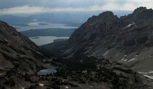
From Paintbrush Divide, descend 2.4 miles and 1700’ to Lake Solitude, which rarely lives up to its name in summer but which might if you start early enough. This might be the prettiest stretch of trail in the park and must be seen to be believed. The Grand Teton is almost always in view, and you also have views of little-visited places such as Micah Lake (plus the small glacier feeding it) and the Wigwams to the west.It is then another 2.7 miles to the junction of South and North Fork Cascade Canyons (you have been in North Fork), at about 7800’. Head down the Cascade Canyon Trail, which is gentle and scenic, though not nearly as spectacular as what you have already hiked through in Paintbrush and North Fork Cascade Canyons, as it descends just 1100’ in 4.5 miles. After about 4 miles, though, look for the signed horse trail heading left; if you reach Inspiration Point, which people who have been above it will not find very inspiring, you have gone too far.
The horse trail lets you avoid the circus-like atmosphere around Hidden Falls, and when the trail bottoms out above Jenny Lake, head left for 1.6 miles to the String Lake and Leigh Lake parking areas. This last stretch of trail can be hot and uninteresting as it passes though a burned forest and you are likely to be very tired.
Summit Views
North-- click for ID details.
East-- click for ID details.
Southeast-- click for ID details.
South-- click for ID details.
Southwest-- click for ID details.
West-- click for ID details.
Other Approaches
Other ways: Park at South Jenny Lake and take the shuttle boat (fee) across the lake to the extremely popular Hidden Falls area and the start of the trail up Cascade Canyon. The shuttles don’t start until 8 A.M., though, which is probably too late for most people to start the route in time to be safe from the afternoon thunderstorms that commonly develop in July and August here. In that event, one can start much earlier and hike around Jenny Lake, but be forewarned that such a decision will make the route about 24 miles RT. 24 might not seem like much more than 20, but those extra miles will hurt at the end, even though it’s mostly downhill. These ways also have longer approaches to Paintbrush Divide. From Hidden Falls, it is 9.6 miles; from Jenny Lake, it is 11.6. You could, of course, hike from Hidden Falls to Paintbrush Canyon first, which makes the divide about an 8.5-mile hike, but you'll be hiking the flattest and least interesting part at the beginning; because of lightning concerns, it's better to get high as fast as possible.Red Tape
Admission to this area of the park costs $25, which is good for a week in both Grand Teton and Yellowstone National Parks. If you visit these or other parks a lot, consider an annual pass or the America the Beautiful Pass ($80) instead; the latter covers entry for a year to all fee areas operated by the National Park Service, the BLM, the Forest Service, the Bureau of Reclamation, and the Fish and Wildlife Service.You must get a permit for backcountry camping. Some are available by reservation after beginning January 1 of the calendar year. See the link to the park website for more information.
Camping and Lodging
The nearest campground is Jenny Lake, which usually fills by 9 A.M. daily. Campgrounds at Signal Mountain and Colter Bay are also within 30-45 minutes of driving. The Gros Ventre Campground is more distant but is much larger and usually only fills on weekends. See the link to the park website for more information. Lodging information is also available there.Park Site-- visit here for information on camping reservations (including for the backcountry), lodging links, other regulations, and more.