Would you like to easily climb the “first” mountain climbed by one of the most famous mountaineers in the world? Nothing is easiest than fulfilling this wish. In front of the green and flat Valle di Tures-Tauferer Tal Valley, in Alto Adige/South Tyrol, is located a beautiful but a bit neglected mountain, named Picco Palù in italian, while Grosser Moosstock (or Mostnock, as even called by the Germans) is the original Tyrolean place-name.
Picco Palù - Grosser Moostock SW ridge
The Grosser Moostock was the first mountain climbed by Hans Kammerlander, the famous Himalayan alpinist, when he was 8 years old. Born in a village at the base of the Picco Palù, he climbed 12 8000m peaks in the 80s and 90s. The history of this revealing experience, together with other interesting tales, is described by Kammerlander in a pleasant book titled “Malato di Montagna” or “Bergsuechtig” (in German), translatable “Mountain addicted”.
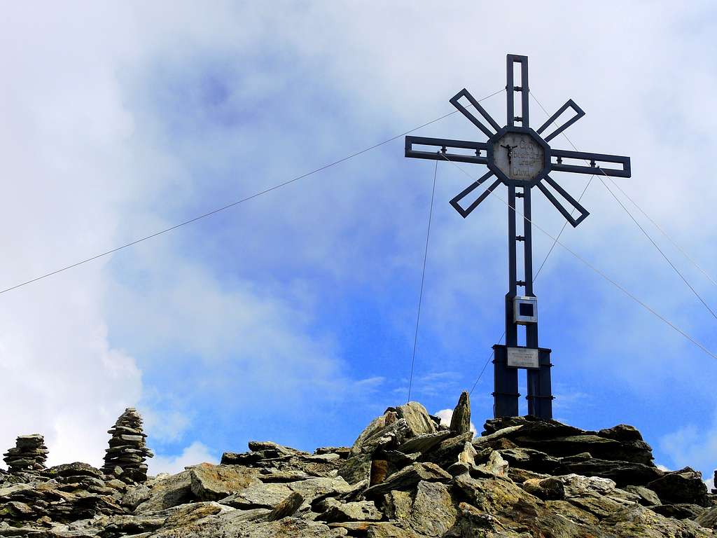
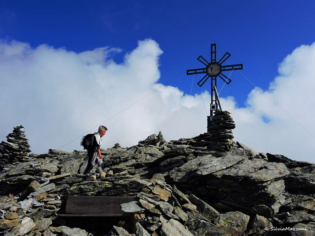
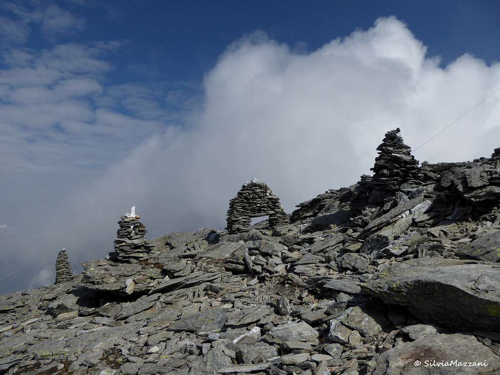
Picco Palù summit cross
The Grosser Moostock/Picco Palù, 3059 meters, is an isolated mountain in the Cima Dura/Durreck Group, including the higher and harder Cima Dura/Durreck (3135 m). It belongs to the wider Venediger Group, at the very SW-end of the mountaingroup. On NW there is the Valle Aurina/Ahrntal Valley, on E the Valle della Lepre/Hasental Valley and on S the Valle dei Dossi/Knuttental Valley and the Valle di Riva/Reintal Valley. The summit is connected to the most important Cima Dura/Durreck by a rocky ridge. This mountain, as well as the overall group, compared to the most famous and ascended mountains close to it, such as the Vedrette di Ries/Rieseferner (Hochgall, Magerstein, Schneebigenock) or the wonderful glaciers of the Zillertal Alpen/Alpi Aurine, could not deserve our attention, but it should be really wrong.
The moraine
The lonely environment and the gratifying view from the top, towards the direction of the mentioned mountains, transform the ascent to the summit in a surprising experience. First of all, mainly in summer when most of the trails in the area are crowded, Moosstock offers to you the perception of the relaxing silence of the mountain. The ascent is easy and remunerative, never stressing. The hikers start walking through a wood (as usual) and touch a very nice old hut placed at the boundary of the wood like a balcony to the surrounding valley and to the Dolomites; it deserves a stop.
the wood
The ascent continues, in a sequence, through beautiful junipers, a moraine, scrambling to a rocky saddle, small lakes, a friendly ridge and finally the summit. All these things are for you, only if you decide to visit a forgotten mountain, leaving the most frequented paths of the area.
Getting There
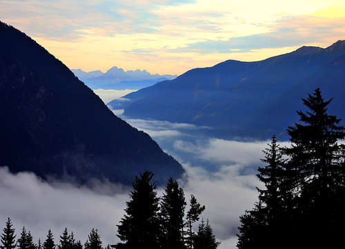
Dawn in Valle Aurina
The main starting point is from the village of Acereto/Ahornach (1334 m).
Take the Brenner / Brennero Motorway A22 from Innsbruck (north) or Verona (south). At Brixen / Bressanone turn onto SS49 into Pustertal / Val Pusteria. Turn north at Bruneck / Brunico onto SS621 into Ahrntal Valley / Valle Aurina. At Sand in Taufers / Campo Tures. Continue to Riva di Tures / Rein in Taufers and follow the indication to Acereto/Ahornach arriving to the village after about 8 km. Overcame the church, the road continues for about 3 km, leaving on your left the indication to Poja/Pojen (1560 m). Park the car after the Stocker alm (about 1640 m) where the road ends; here is a pile with clear indication to Moostock/Picco Palù (trail n° 10B).
You can reach the Val Pusteria Pustertal Valley also:
-from North (Kitzbühel south, B161 - Felbertauern Road, Felbertauern Tunnel, Lienz, Pustertal Valley); -from East (Motorway A2 from Klagenfurt to Villach, A10 north to Spittal, west onto B100, Lienz, Pustertal Valley); -from South (motorway A27 from Venezia north to Belluno, SS51 north to Cortina d'Ampezzo, Toblach/Dobbiaco, turn north at Bruneck / Brunico.
Routes overview
Grosser Mosstock/Picco Palù can be climbed by three main different routes, corresponding to three ridges. The height difference of about 1500 m allows to climb the mountain by the day.
Summit altitude: 3059 m Difficulty: F Difference in level: 1495 m from Gasteiger Exposure: SW Starting point: Parking lot near Maso Gasteiger
The easiest and most frequented route by a well marked trail (n°10B), a truly beautiful climb in the wild, with superb views of the surrounding mountains belonging to the Vedrette di Ries and the Aurine Alps. The route is signposted by white-red marks and by several cairns.
Getting the summit of Picco Palù
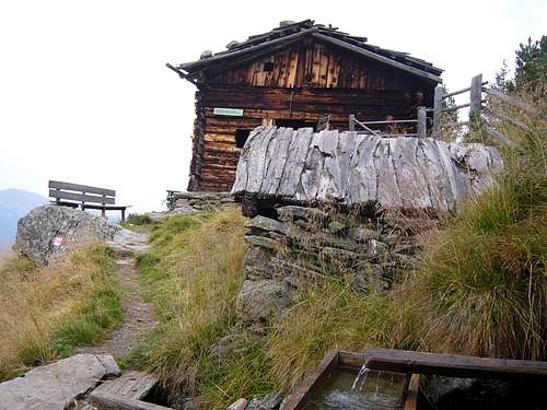
The route starts at about 1640 m. Take the paved road at the bend to the left of the parking lot, following the signpost n 10B. Continue briefly along the road, then take a path in the fine coniferous forest (signpost Picco Palù and Schlafhauser). After about half an hour we cross a fence and arrive near an alm; the trail continues in the midst of a slope with vegetation on a sparse forest of "cirmoli" up to the interesting Schlafhauser Alm 2010 m, a wooden shelter with stove. It is placed in a wonderful position at the junction of our itinerary and the trails to Riva di Tures (Vegetation Weg) and to Poja Valley (Durreck Hohenweg). The alm is unguarded.
the hutApproaching Picco Palù
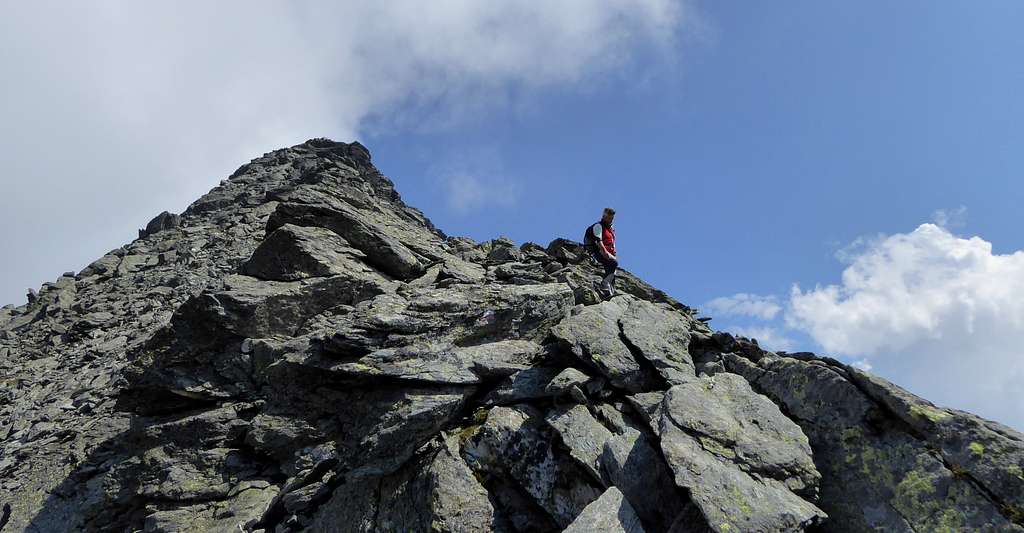
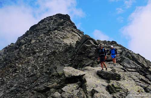
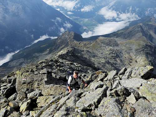
At the crossroad near the alm, continue directly on the path 10B (signposted "Moosstock") in the sparse forest of "cirmoli" pines, then on open pastures, reaching a steep slope. The route continues through a little valley between the Zintnock (2623 m) and the Klein Moosstock (2630 m). After an easy and short rocky passage, the route crosses slanting left up to the base of a rocky stretch, equipped with a metal cable to facilitate the overcoming of a small overhang (easy). Always on rocky ground and a chaotic slope of boulders (cairns) the route reachs the summit of the wall and then a marked shoulder at about 2700 m, from which it appears Picco Palù.
Picco PalùPicco Palù summit ridge
The summit is on your right side while a little lake (Moosstocksee, 2774 m) is on your left. From the saddle the SW-ridge is on the right, so the route now head to the right to get the start of the rocky ridge. By a direct easy climb on the SW ridge (about 250 m) on rock of good quality you arrive on the flat summit. The alternative path on the scree to the left of the ridge is easier, but on unstable ground and not so funny. The wide flat summit is wonderful and the panorama is exciting! (4:45-5:15 h, F/F+).
Descent: usually by the same way.
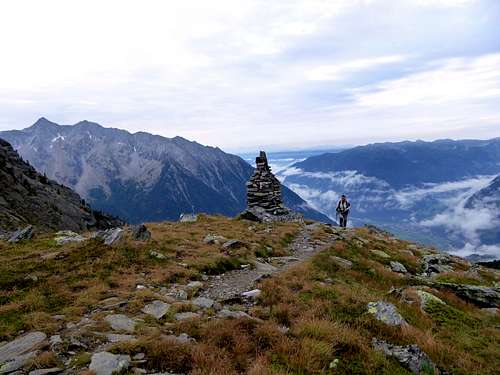
Picco Palù summit cairns
SW-side
Pojen Tal
-NE ridge: first ascent by Schmitt and Sieger, on 1899. The route is done mainly as descent after having climbed the Durreck/Cima Dura. The route runs mainly along the Valle di Poja/Pojental Valley;
-S-ridge: usually used as descent in connection with the ascent by the SW ridge (F/F+). The route connects the summit with the village of Rein in Taufers/Riva di Tures or by the trail “Vegetationweg” (Vegetation route) comes back to the Schlafauser Alm in the direction of Acereto/Ahornach.
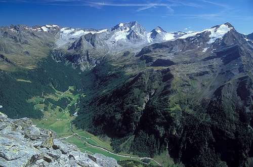
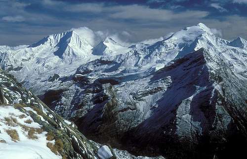
From the summit you have a 360° view of the surrounding mountains, from Rieserferner to Zillertal Alps.
Rieserferner's view
Biking
Biking
You can have fun, not without any effort (Tiziana reports), biking in the Val di Poja/Pojental valley. Starting from Campo Tures (Sand in Taufers) at 864m, continue to Acereto/Ahornach, Pojen and Val di Poja/Pojental till Malga/Alm Poja, placed at 2040 m. The trail in Val di Poja/Pojental is hard and very steep, you often must push the bike. From Malga/Alm Poja you can hike towards the Moosstock summit, even if the best option is from the trail n°10c from the SW-side (Acereto/Ahornach).
Red Tape
No fees no permits required
Refuges and accomodations
On the way
Schlafhauser Alm
Many B&B (so called Garnì) are present in the valleys. Information on the accomodations (types, prices, booking, etc.) are available on this web page of the Ahrntal / Valle Aurina's touristic office.
Ascending through the SW side the Schlafhauser Alm (2010 m) represents a very good refuge in case of bad weather. It is placed in a wonderful position where the trail towards the Moosstock is crossing the trails directed to Reintal valley (Vegetationweg)and to Pojental valley (Durreck Hohenweg). A refreshing well invites you to rest for a while looking the panorama. No food or beverages are available: the alm is uninhabited.
When to climb
I climbed Grosser Moosstock from SW ridge in summer. In early summer is easy to find snow fields just above the saddle. Not recommended with bad weather condition (as I tested): this area is characterised by high risk of lightnings and the climb of the ridge, due to the bad quality of the rock, can be more difficult with rain.
"Alpi Pusteresi - Vedrette di Ries" - F. Cammelli, W. Beikircher - Collana Guide dei Monti d'Italia CAI/TCI Milano, 1997; ISBN 88-365-1110-4 "Prestigiosi 3000 del Sud Tirolo"- Hanspaul Menara Athesia, Bolzano
"Monti Rifugi Paesi delle Valli Aurina e Pusteria", L.A. Fincato Ed. DIP-Druck, Brunico (2000).
Children refers to the set of objects that logically fall under a given object. For example, the
Aconcagua mountain page is a child of the 'Aconcagua Group' and the 'Seven Summits.' The
Aconcagua mountain itself has many routes, photos, and trip reports as children.
Parents refers to a larger category under which an object falls. For example, theAconcagua mountain page has the 'Aconcagua Group' and the 'Seven Summits' asparents and is a parent itself to many routes, photos, and Trip Reports.


 12737 Hits
 92.85% Score
 40 Votes


 Rieserferner's view
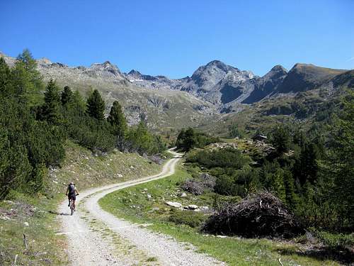 Biking

 The first snow