
|
|
Mountain/Rock |
|---|---|
|
|
34.21680°N / 117.4894°W |
|
|
Hiking |
|
|
Spring, Summer, Fall, Winter |
|
|
5240 ft / 1597 m |
|
|
Brush Lover's Dream
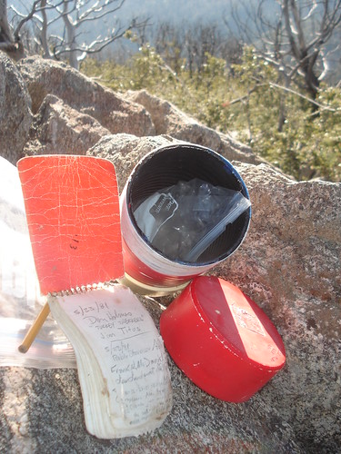
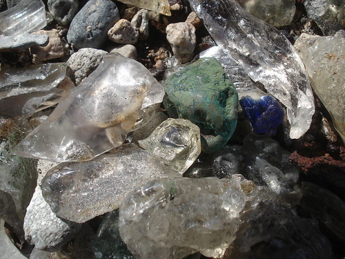
If you love hiking through heavy brush then San Sevaine Lookout is for you! Located at the far eastern regions of the San Gabriel Mountains, San Servaine is mainly visited by Sierra Club Hundred Peak Section (HPS) Members working to complete the "list". Most will combine San Sevaine Lookout with nearby Buck Point, another HPS peak. San Sevaine Lookout is actually the Eastern Most HPS peak in the San Gabriel Mountains and is lower in elevation than much of the surrounding area. Some may ask why else bother to bushwhack all the way out there if it wasn't for the list, well, I think there are many reasons, but I will leave it to the few who chose to hike out there to figure out what they are. But seriously, you don't need to be a sadomasochist or a flagellator to enjoy this peak, the views are nice, scenery is beautiful and the remnants of the lookout are interesting.Today, all the remains of the Lookout are many foundations and a lot of melted glass. Obviously the lookout was burnt in a very hot fire. The lookout is located south of the actual highpoint; a pile of rocks where the summit register is located (which dates back to 1981).
History
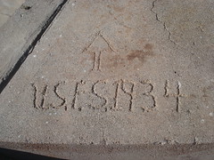
 Old Foundation
Named for a French pioneer and vineyardist, Pierre Sainsevain who settled south of this peak (1839). He was a nephew of Luis Vignes, whose hacienda was a famous gathering place in his day and whose wines (made mostly from the black "Mission grape") became the first agricultural export of Los Angeles. Vignes founded the once famous and extensive Aliso vineyard in what is now downtown Los Angeles. It covered over a hundred acres and included a grape arbor one quarter mile long-the narrow road that once bordered the property is still called Vignes Street. To begin his own vineyard, Sainsevain dug a well near this peak and built the "Don Pedro Reservoir" to irrigate the vineyards in the northeast portion of Rancho Cucamonga via an elaborate flume system (1865). The attempt proved a failure except in years of heavy rain, but even so, Pierre and his brother Jean-Louis (who spelled his name Sansevaine) became known as prenuer wine makers.
Name was hispanicized to the present spelling at a later date. This area has many boulders with mortar holes that are considered evidence that this was also once the site of a seasonal rancheria for the Serrano Indians. A rustic CCC "spike camp" was established here for the use of hunters (1935).
A USFS fire lookout was built consisting of 10' timber tower with a 14' by 14' cab (1935).
Don Bauer, Forest Supervisor (ca.1950's) recalls that the twin sugar pines on this ridge have been protected as a USFS tradition because of an experience by early Ranger Dale Gentry, who later became State Commissioner of Fish and Game. He was once caught here in a blizzard while hunting in the 1880's, and survived a night in the snow by covering himself with pine needles and using the trees as windbreaks. In gratitude, Gentry purchased the peak. When he deeded the land to the USFS it was with the understanding that these trees would be forever spared.
Sequoia trees were planted here by Jim Graham just after WWII
Name of adjacent San Sevaine Flat and San Sevaine Springs first appear in the USFS San Bernardino N.F. map (1926) and only later was this name extended to this peak.
Name first appears on AMS San Bernardino quad (1943).
Peak was added to the HPS Peak List in 1965.
Getting There
 Topo map of South Ridge Route
The HPS website for San Sevaine Lookout lists the Fire Road 1N34 as the primary route. However, it appears that the gate at the start of this road is always locked, except for maybe a few weeks in September. To get to this road, take the I-15 North past the 210 Freeway and take the Sierra Ave. exit. Turn left and drive 1.6 miles to the dirt road.
You can also access the area via 1N36 road from the end of Cherry Ave. If the gate to the newly developed private community is open, you can drive to the end of Foxborough and park at the cul-de-sac. Then hop the fence and follow the old fire road 1N36 up to it's intersection with 1N34. 1N36 is in pretty rough shape, but it goes quite well.
My preferred route is the south ridge accessible from the north end of Etiwanda Ave in Rancho Cucamonga. This is a challenge due to significant elevation gain and brush. The topo Map to the right shows this route and for more info. please see the route page.
For the real hearty (and brush loving) souls, you can also climb this peak from the north via Bonita Canyon. Here are some pictures of this route.
Final Approach
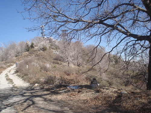
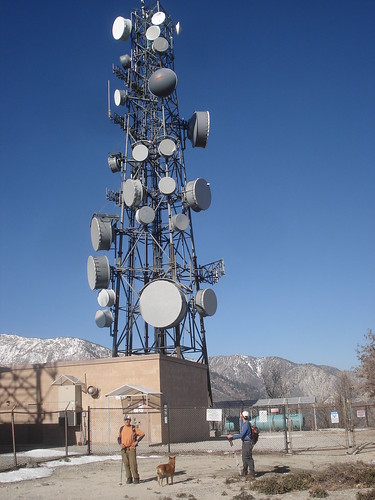
Regardless what route you use to get onto the fire road 1N34 you will need to brave some brush to reach the summit and lookout tower foundation. Near the radio towers that can be viewed from along 1N34 you need to leave this road and head north at the gate shown in the picture below. You hike a short distance until you can see the radio towers directly ahead. At this point the "road" to the lookout it immediately to you right (east).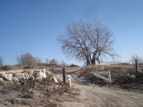
I built a cairn at this location since this road is difficult to spot. There is an Oak tree, a Telephone line Marker and a large berm pit at this location. The road is so overgrown you will look at it and think to yourself, "this is a road?". But, yes, this is the road. The worst section of brush is actually right at the beginning.
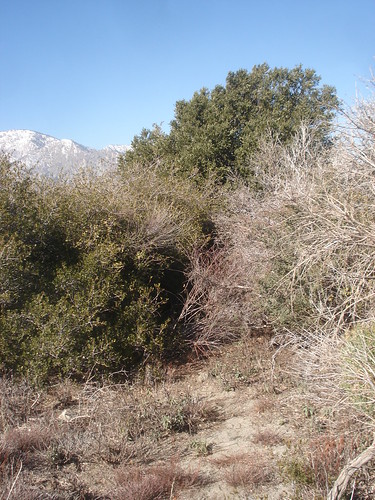
An alternate route that we accidentally ended up hiking since we missed the overgrown road turnoff is to hike up to the radio towers and head east along the ridge. The ridge itself is fairly brush free and scenic. Basically follow the ridge as far as you can until you start descending towards the saddle. Keep to your right (south) as best you can while avoiding thick bush at the same time. You should meet up with the road at the bottom of the saddle and can follow it from there up to the summit. You can follow this road approx. 1 mile to the summit. San Sevaine Lookout is actually at a much lower elevation than the radio towers, so don't be surprised if you are losing a lot of elevation on the approach.
Camping
There is a campsite approx. 3.5 miles west of San Sevaine Lookout along the fire road 1N34 at the site of the former Joe Elliot Memorial Tree (the tree is now dead, but the area is still maintained).GPS Data
The following website has GPS tracks of the Etiwanda Ave. south ridge route along with elevation profile, Google Map and Flickr photos.http://www.gpsmountaineering.com/sanservainelookoutandbuckpoint
tarol - Sep 16, 2008 5:07 pm - Voted 10/10
Joe Elliott CampgroundIs not maintained... the fires in '03 killed a lot of trees in the area and now there is nothing more than maybe an old firepit here or there amongst the brush... no bathrooms, no tables, no water, no shade, no trash service... you're on your own if you camp there!
tarol - Sep 16, 2008 5:09 pm - Voted 10/10
San Sevaine Road Re-opening 9/21/08See this news release