
|
|
Mountain/Rock |
|---|---|
|
|
37.03433°N / 110.8686°W |
|
|
San Juan |
|
|
Hiking |
|
|
Spring, Summer, Fall |
|
|
10346 ft / 3153 m |
|
|
A Sacred Mountain
According to this link, it is mentioned that the Navajo Nation does not permit ascents of Navajo Mountain. Be aware of this and realize that to attempt to climb this mountain is in their view, trespassing. Due to this information, I have deleted a lot of information from this page that described my route to the top and have no answer as to how to "legally" access this mountain. I will quote SP member westanimas below:
"Take seriously the need to inquire about access and obtain the necessary permits."
"Trespassing, or crossing tribal lands without the correct permit, is a BIG NO NO. A technical argument can be made that if the road to the towers is managed by the Bureau of Indian Affairs, then it is a public road, and therefore it is public access (on the road and in your vehicle only.) However even if this is true, leaving the pavement on any reservation is not a good faith approach to crossing tribal lands. And the tribal police do patrol.
Tribal lands are not public lands."
"Please respect the policies of the Navajo tribal government and the Navajo tribal membership and inquire about the appropriate method to access or travel beyond any unpaved roads. There are areas where tribes explicitly invite public access, and there are places where they explicitly do not. This comes from my experience being employed in a tribal government myself. If you are willing to test the gray area of unpaved roads and leave your vehicle on foot, you must have the correct permit or be accompanied by a tribal member."
For the entire text of SP member westanimas's comments, see the addition correction section at the bottom of the page. I think what he is saying is worthy of including here and that all of us need to take heed.
Overview
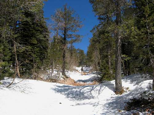
Walking back into winter
Navajo Mountain is one of the most dominant features seen in this part of Utah and Arizona. A very visible mountain, it stands alone with nothing even near it. It has the shape of a beached whale (to me anyway). Located just across the Arizona-Utah border, it is totally on the Navajo Indian Reservation and is considered to be a sacred mountain to the Navajo people.
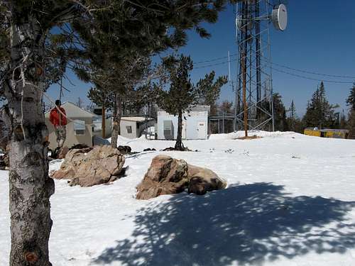
Navajo Mountain, a large laccolithic dome and is called Naatsis'áán by the Navajo people, its meaning is Head of the Earth. The top of the mountain is marred by a radio facilty/towers/structures and other stuff that definitely do not belong on a sacred mountain but in this day of needing communications placed in high places, even that aspect seems to be compromised on this mountain.
Navajo Mountain is a prominence peak having 4226 feet of clean prominence which makes it number 13 on the Utah list. Prior to it being sought after as one of Utah's higher prominence peaks, it was often the last one done by those who were chasing the Sierra Club's Desert Peaks. (scroll down to section 7) A very very long way from California, folks in Los Angeles would make the 600 mile drive to claim this one. Consider this 1969 trip report by John Vitz.
The famous Rainbow Bridge is nearby and a rough cross country route to the bridge exists that some folks use. Information wise, I have nothing to share on that as I have not done it. I'll see about providing a link to it later on after the majority of this page is finished.
Totally non technical, this mountain can be walked up via a very rough 4WD road that runs to the top to service the towers. A Utah history site said that " Official documentation of the occupation of Navajo Mountain began with Spanish explorers and Catholic fathers Anastasio Dominguez and Silvestre Velez de Escalante, who "met only Paiutes" when they forded the Colorado River near Navajo Mountain in 1776. The San Juan Paiutes and Navajos occupied the surrounding mesas and rugged canyons in the early 1800s." More history can be found HERE.
BE RESPECTFUL OF THE NAVAJO RESERVATIONS LAND AND SPEED LIMITS.
Please do not leave any kind of litter or trash, try and be a good guest
so that others will be able to visit and hike this mountain.
Getting There
If you come from Flagstaff, you will take the turnoff for highway 160 to Tuba City and continue easterly until reaching the junction for highway 98 which heads for Page. About 12 miles up this highway watch for the turnoff to Indian road #16, which is now paved all the way to the turnoff for the power line road that leads up the mountain. I'm not positive on the distance from the turnoff from highway 98 to the turnoff for the dirt power line road but it is in the range of 40 miles. You can drive your vehicle up the power line road as far as your clearance and driving ability will allow but you should do this only if you have permission.
The road becomes very rough after a couple miles and only high clearance 4WD vehicles should think about going further. It was reported recently to me that the road has been "improved" for tower vehicles so the condition may be within reason.
It is a long way from a tow truck or help. Overall, it is roughly about 165 miles from Flagstaff but I'd suggest you study your maps rather than rely on
my figures.
From Page, take highway 98 55 miles to the turnoff for #16.
To find the power line road:
Zero your speedometer when you pass the posted Utah-Arizona border. You will pass a small airport on your left at 0.7 miles and just beyond you will find a powerline crossing the road. The powerline road is here, turn left (west)onto it. Proceed west 2.4 miles on the powerline road to a small repeater station beside the road in the flatlands. Here the road bends to the north and heads up the mountain to the towers on the summit. You might wonder why you shouldn't just drive up this road since there are towers on the top? It seems that the ones who service the towers have permission to do so from the Navajo Nation and as far as I know are the only ones who have permission.
Red Tape
A permit is required to be on Navajo lands and Cameron is the place to get one. Cameron is 46 miles from Flagstaff and the Navajo issuing station is on the west side of the highway where highway 64 comes in from the Grand Canyon. Regarding getting a permit for Navajo mountain is now clear, you won't get one. SP member westanimas has put some input regarding the need for a permit. He was denied a permit and others will most likely suffer the same fate. Please visit the Navajo Tribal page, it does indicate that climbing Navajo Mountain is off limits. I'm not clear if that means you can't drive up the road to the summit but that question is best answered by the person you talk to in Cameron. It seems to be doubtful if you read their comments on their web page.
From their web page:
Navajos consider Navajo Mountain as a sacred area, and ascending it is forbidden.
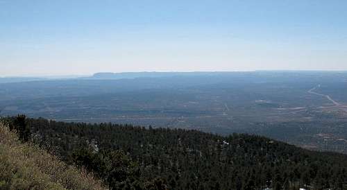
Black Mesa in the distance
-------------------------------------------------------------------
HIKING & CAMPING (From this link)
The Navajo Nation is comprised of more than 25,000 square miles and offers hikers numerous isolated trails and routes. For the safety of hikers who enter the reservation and for the protection of natural and cultural resources, the Parks and Recreation Department has implemented guidelines for backcountry use.
The trails are not improved or maintained, and are usually marked with rock claims. To reach the trailheads, topographic maps and drives over rough dirt roads are required. Roads can become impassable in wet weather, and conditions can change quickly. Travelers are cautioned to be prepared. To ensure having an enjoyable experience, plan your trip carefully. Most trails are rated strenuous to moderately strenuous, and good physical conditioning is important. The terrain is rough, water is scarce and the weather is often extreme in most areas.
In summer, the trails are hot and dry; in winter, elevations make them subject to severe cold and high winds. Due to the quick changes in the weather, be aware of the dangers of flash floods. While this danger is greatest during the summer monsoon season (July through September), flash floods can occur at any time of the year.
Camping fees: $5.00 per person, per night for anyone over the age of 6. Fees subject to change.
You willl need to obtain a camping permit from one of the following locations listed below.
Backcountry permit fees: $5.00 per person, per day.
Cameron Visitor Center
P.O. Box 459
Cameron, AZ 86020
tel : 928.679.2303
fax:928.679.2017
email: lcr@navajonationparks.org
This visitor center is located at the junction of Highway 89 and Highway 64 in Cameron, Arizona. Information and permits can be obtained for trails along the Colorado River, Marble Canyon, Jackass Canyon, Salt Trail Canyon, Totahatso Point, Rainbow Bridge trails, Cove Mesa, Coal Mine Canyon and areas in the western portion of the Navajo Nation.
Camping
Navaho National Monument has camping for no fee. Located to the east of the highway 98 junction, it is about a ten mile or so drive to road 564, that leads up to the Monument, a 9 mile effort to reach the campgrounds. Nice facilities and based on first come, first served. We spent one night there after doing Black Mesa and went on from there to do Navajo Mountain. It worked out well. We then left early to get to the trailhead (which is whereever you end up parking)
Navajo National Monument Good link with map & more info.
A camping permit to camp on Navajo lands is $5.00 and more specifics can be found on the Navajo Nation website. (HERE)
Weather for Page AZ, closest town
 Summit Hardware
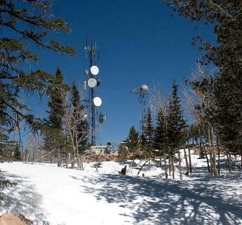
Summit hardware
westanimas - Oct 25, 2013 4:46 pm - Voted 10/10
Tribal LandsTake seriously the need to inquire about access and obtain the necessary permits. Trespassing, or crossing tribal lands without the correct permit, is a BIG NO NO. A technical argument can be made that if the road to the towers is managed by the Bureau of Indian Affairs, then it is a public road, and therefore it is public access (on the road and in your vehicle only.) However even if this is true, leaving the pavement on any reservation is not a good faith approach to crossing tribal lands. And the tribal police do patrol. Tribal lands are not public lands. Please respect the policies of the Navajo tribal government and the Navajo tribal membership and inquire about the appropriate method to access or travel beyond any unpaved roads. There are areas where tribes explicitly invite public access, and there are places where they explicitly do not. This comes from my experience being employed in a tribal government myself. If you are willing to test the gray area of unpaved roads and leave your vehicle on foot, you must have the correct permit or be accompanied by a tribal member. This is not optional.
Dean - Oct 25, 2013 11:41 pm - Hasn't voted
Re: Tribal LandsYour input is appreciated. I've changed the red tape section to reflect the seriousness of needing a permit and your comments might make others realize that it isn't an automatic and need to plan accordingly. I've made reference to your comments under the red tape section. It is probable that I'll delete this page from Summitpost since it is clear from the Navajo web site that ascending Navajo mountain is off limits.
westanimas - Oct 26, 2013 9:37 am - Voted 10/10
Re: Tribal LandsHello Dean, Thank you for updating the red tape section. I didn't want to come off too forcefully, but I did want to be clear about the issue. I used to do natural resources management for the Southern Ute Tribe, and it was my job to spend over 30 hours a week in the field and on tribal lands. I was fortunate to have that experience, but I learned from "inside the reservation" how amazingly complex and frustrating this issue can be for many Tribes. I cannot even begin to describe how much abuse of indian lands is still occurring, and how sensitive this issue still is. However, I would not recommend deleting your page :) If you are up for tinkering with it a little more, it's still a great media for conveying the correct information. I'm sure a lot of people are googling pages about this mountain, and summitpost is a great venue to convey the things that the public needs to know. You also have some great geographical information here, and I think that is extremely valuable thing to expand for all people who notice the prominence of this mountain and who want to better feel their sense of place in this region. You may want to restate your new comment about the access issue at the top of the overview section (many people won't read thoroughly down to the red tape section.) However, you also have the chance here to add additional sections, or even children to the page, to discuss areas in the region that are public access, and which offer great perspectives on the mountain. Antelope Canyon near Page, AZ, comes to mind, and so does the view from the lower canyons of the Escalante. It's also possible to hire interpretive guides at many of the Navajo parks, and while you wouldn't be hiking on the mountain itself, I'm sure it's still possible to do an interpretive tour of the mountain from a nearby landmark.
Dean - Oct 27, 2013 9:46 am - Hasn't voted
Re: Tribal LandsI've redone the page to reflect your information. Check it out. I've also eliminated the route section, a map and references to using the road to the summit as a route. Whether this will keep others from going to the summit, at least now they will be more aware that it is a trespassing situation.
gralpinist - Oct 28, 2013 10:25 am - Hasn't voted
Navajo Mt.Navajo Mountain may be considered a "sacred area", but, it is not one of the 4 sacred Navajo Mountains. Those are: Hesperus (CO), Mt. Taylor (NM), Blanca (CO), and the San Francisco Peaks (AZ). I lived and worked on the Navajo Reservation for 18 yrs and had the opportunity to drive to the top of Navajo Mt. in a military-style humvee. I have also hiked the Navajo Mt. trail which goes around the base of the peak, ending at Rainbow Bridge on Lake Powell. I would usually hike and travel with Navajo friends, which prevented unpleasant encounters with some locals. It is unfortunate that more and more places on Indian lands are being designated "sacred" to keep non-native Americans out. Having an active--and workable--guiding/tourist process would benefit everyone.
Dean - Oct 28, 2013 12:34 pm - Hasn't voted
Re: Navajo Mt.Thanks for your comments. I know that Navajo Mountain is going to still get a lot of activity and a friend recently went up the road a couple of weeks ago and was treated in a welcoming manner by some members of the Navajo tribe while he was there. Still....
McCannster - Oct 28, 2013 3:07 pm - Voted 10/10
Re: Navajo Mt."...and was treated in a welcoming manner by some members of the Navajo tribe while he was there..." Shouldn't this be proof enough that Navajos encountered on Navajo Mountain don't mind non-Rez folks being there? I've never heard of anybody being verbally harassed or of any law enforcement patrolling the area, looking for people hiking "the forbidden mountain". Permits/regulations etc do exist and serve their purposes, but for peakbaggers, you should be able to get by without all that as long as you are respectful of the land, don't litter, vandalize, blah blah blah (which peakbaggers are 99% of the time anyway). All this info coming from westanimas, while certainly relevant, isn't quite warranted for this peak, IMO. From my experience, peakbaggers on Navajo Mountain is pretty far off the Navajo Nation police's radar.
surgent - Oct 28, 2013 6:05 pm - Voted 10/10
Re: Navajo Mt.In my 20+ years in Arizona and having explored most of the various Indian Reservations in the state, you pick up on the vibe of each place, and know what is cool and what isn't, and so on. The Navajo Nation is (to me) by far the most accommodating to outsiders, in that most of it is accessible as long as you have a permit and aren't treading toward the obvious/well-known sacred areas, or in someone's front yard/pasture. I have been to a few locales on the Navajo Nation that weren't specifically designated as "open for tourists", but we had no resistance whatsoever when procuring our permits, and we always told the Navajo Rec people exactly where we'd be going. In encounters with the locals, we have been honest and forthright, asking if it's okay for us to be here, and they have always been very friendly and accommodating. It boils down to just basic respect, honesty and friendliness. Now, that won't mean you may encounter someone who has a problem with your presence. If that happens, back off and let things cool down. My experiences are anecdotal but the preponderance of experiences suggest that most places on the Navajo Nation are "possible" if you are willing to do some research up front, be honest at all stages, and maybe look into a guide if you feel unsure.
westanimas - Oct 29, 2013 10:51 am - Voted 10/10
Tribal LandsHello Dean, Thank you very much for your consideration here. I think the way this thread has developed shows how useful it is to have this page on summitpost. Our individual choices and consequent actions toward land management, cultural sensitivity, and unresolved access issues, eventually circle back over time and build the public reputation of the outdoors community. We come to the table with this reputation, inherited through others in our community. This reputation is very much the basis behind developing a land management plan that could allow public access to a given area, and even an official's individual decision whether to issue a crossing permit. It's analogous to opinions that have formed over the years about hunters and ATV riders, and what we believe are the respective responsibilities of those sports. I see comments from members in this thread that touch on honesty, research, and being accompanied by a guide. This is how I made some wonderful, and legitimate, trips into places like the Ute Mountain Tribal Park and also Canyon de Chelly- where the tribes were explicit in requiring me to have a guide. It's not my place to question why a permit couldn't have done the job, or why I even needed permission at all. I'm not a tribal member and it's not my land. Moving forward, climbers, hikers, and the summitpost community have a responsibility to act as good stewards of the lands they are enjoying. I think everyone can understand that tribal lands are not public lands. How we are perceived will determine our future reputation and ability to come to these places. It is in everyone's interest to take the good faith approach.
jkalember - May 12, 2014 6:54 pm - Hasn't voted
Alternate routeFrom the dirt road on the SE flank, the power lines can be followed directly to the summit, up and back. With proper permission from the Navajo authorities, of course. This route is not intrusive and is not near any structures or fields.
jdmorehouse - Aug 12, 2015 1:06 pm - Voted 9/10
Web site downAs of August 12, 2015, the Navajo Nation website has been down for at least a month (since I started trying to access it for permit information). I was going to try to climb the mountain on the return trip from Colorado last week, but could never get any information, and so didn't go. The web site continues to be down.