
-
 15539 Hits
-
 93.35% Score
-
 42 Votes
|
|
Mountain/Rock |
|---|---|
|
|
46.55637°N / 12.00136°E |
|
|
Bolzano - Alto Adige |
|
|
Trad Climbing |
|
|
Summer |
|
|
9429 ft / 2874 m |
|
|
Overview
Geographical classification: Eastern Alps > Dolomites > Fanis Group > Cima Scotoni
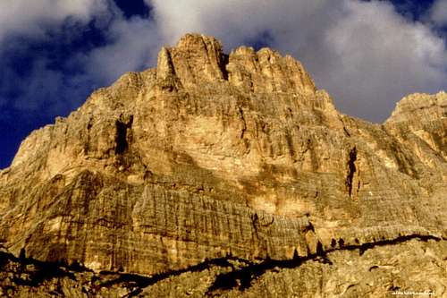
Cima Scotoni, the queen of the Fanis Group
In the Eastern Dolomites, just near the well known Passo Falzarego, a valley, through Passo di Valparola, gets to the Val Badia. The eastern border of the upper portion of this valley is the Lagazuoi-Fanis group. Cima Scotoni is an important summit belonging to the Fanis Group, overlooking with its grey, yellow and red walls the superb Val Lagazuoi, starting from Capanna Alpina 1729 m. Cima Scotoni is located just South to the first peak you can see walking along the path, Cima del Lago, and it is divided from this latter by a steep channel. Cima Scotoni rises projecting towards the sky its awesome South-West face, one of the most important goals of the whole Dolomites. Notwithstanding this peak has been considered as the West shoulder of Cima Fanis di Mezzo, it's quite an important and well individualized summit of the Fanis group and the most famous one, due to the challenging climbing routes realized on its SW face. The impressive and massive wall is crossed by two regular ledges, dividing the wall in three sections.
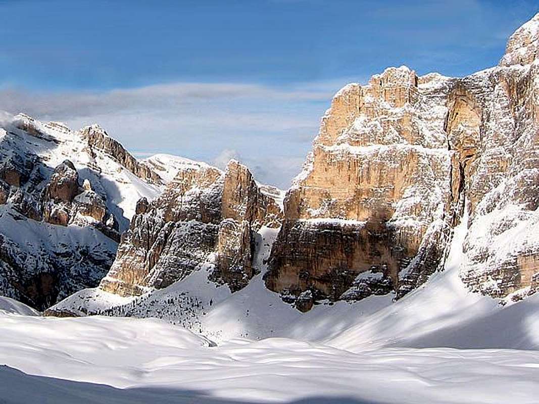
A winter image of the impressive SW wall of Cima Scotoni - Photo Gabriele
Getting There
The starting point is the place named Armentarola, located just a few kilometers from both Passo Falzarego m. 2105 and the small alpine village of San Cassiano m. 1530 in upper Val Badia.
Getting to Armentarola and Capanna Alpina m. 1729
- From Bolzano: follow the Brennero Motorway towards North, exit Bressanone and then follow the Val Pusteria road to Brunico. In Brunico turn to right, following the Val Badia road to Pedraces, La Villa, San Cassiano. A few kilometers after San Cassiano leave the main road leading to Passo Valparola and Passo Falzarego and turn to left towards Armentarola and Sass Dlacia. Drive on an unsurfaced road getting to a large parking lot near the Capanna Alpina (1730m). If you need a place to spend the night nearby Cima Scotoni, the best starting point could be Rifugio Scotoni m. 1985, where you can go with a fine walk of less than an hour from Capanna Alpina.
- From Cortina d'Ampezzo: follow the road SS48 getting to Passo Falzarego. From the pass turn to right towards Passo Valparola, Armentarola and Val Badia. Before getting to San Cassiano, leave the main road and turn to right to Sass Dlacia and Capanna Alpina.
Walking access to Cima Scotoni
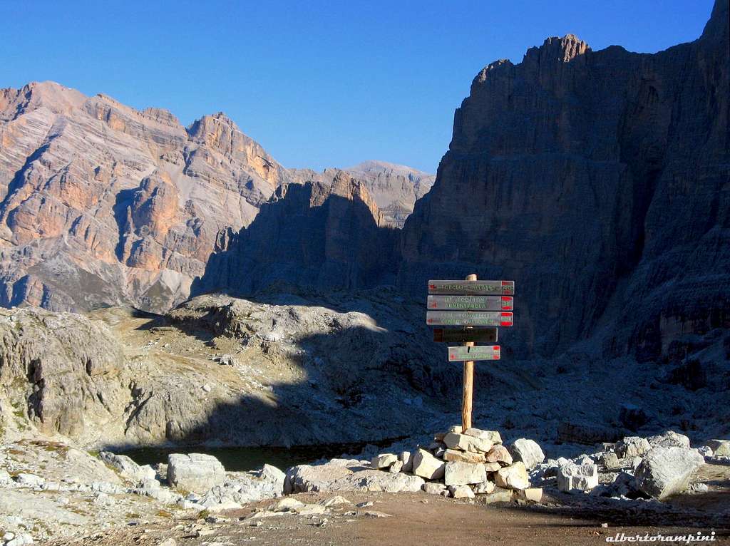
From Capanna Alpina m. 1729 follow the path n. 20 to Rifugio Scotoni m. 1985 and continue past the small alpine lake on a trail getting the bottom of the face (1 hour and 15 minutes from Capanna Alpina).
History
The peak was dedicated to the memory of the mountaineer Luigi Scotoni, famous his 1st solo ascent of the great Northern Edge of Crozzon di Brenta at the age of seventeen. The summit was climbed for the first time in 1909 by W. Thiol, that reached it descending towards West from Cima Fanis di Mezzo. The first ascent of the massive SW wall was carried out by E. Costantini, A. Apollonio and B. Pompanin along a route that runs on the right end of the wall, where this latter was found to be more affordable. The most notable event was the first ascent of the SW wall in the year 1952, climbing a very direct route. The exploit was realized by the Scoiattoli di Cortina L. Lacedelli, L. Ghedina and G. Lorenzi, who found a line in the middle of the impressive overhanging wall with great intuition.

Routes Overview
All the routes of Cima Scotoni
Normal Route: Cima Scotoni can be easily climbed (II UIAA) along the NW ridge, directly from Forcella del Lago, the notch between Cima Scotoni and Cima del Lago or, easier, crossing the summit ridge from Cima Fanis di Mezzo; this routes are the Normal itineraries to climb the summit and normally used to come back after climbing the South-West wall.
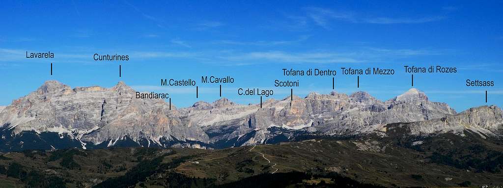
Cima Scotoni SW wall from Forcella Lagazuoi - Photo Alberto Rampini
The impressive South-West wall is the main interest for the climbers who want to climb its beautiful and challenging routes. Starting from the NW ridge, we have the following routes from left to right:
West wall
- Barbier-Comploi - 550m - TD (5.10)
South-West wall
- Direttissima Ivano Dibona (Valleferro-Menardi-Dallago) - VI+ and A1, 630 m.
- Direttissima Scoiattoli (Lacedelli-Lorenzi-Ghedina) - VI+ and A1, or VIII- 630 m. L. Ghedina, L. Lacedelli, G. Lorenzi 10-12/06/1952. The most famous and climbed route of the face, a great classic of the Dolomites, which the "Scoiattoli" realized with great insight, tracing a challenging course in the middle of the overhanging wall
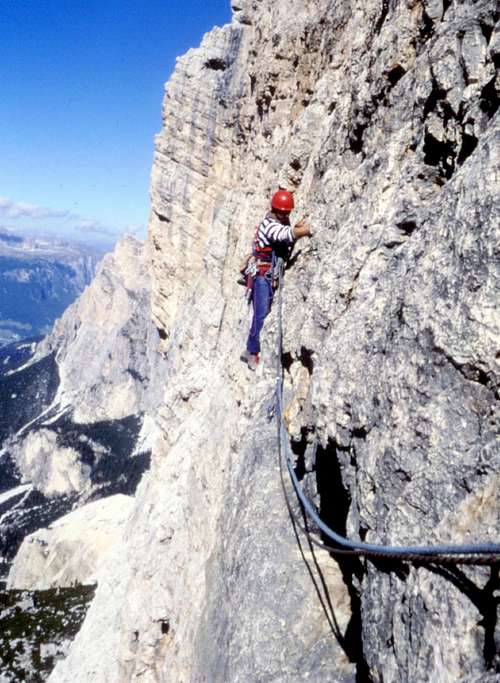
Exposed traverse on Direttissima Scoiattoli (Lacedelli-Lorenzi-Ghedina)
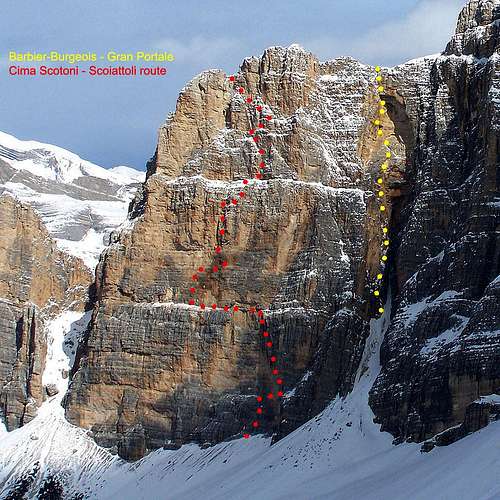
Beta of Diretta Scoiattoli and Barbier-Burgeois on Gran Portale - Photo Gabriele
- Zauberlehrling (Apprendista Stregone) 7b+ - 700 m. Christoph Hainz e Osvald Celva 1990 - Running between Dibona and Hyperscotoni
- Hyperscotoni 6c 450 m. A. Leviti- F. Mich 1984 The route joins Direttissima Scoiattoli on the first ledge and shares two pitches with this route, then continuing up directly and ending on the second ledge
- Skotonata Galactica - 7c+ (or 6b and A0) French Scale 400 m. B. Tassi- G.B. Calloni- I. Zanetti 1994
- Via dei Fachiri UIAA VI, 450 m. Enzo Cozzolino - Flavio Ghio 1972 (Winter ascent) - The route ends on the higher ledge of the wall
- Route Costantini-Apollonio-Pompanin - V, 600 m. - E. Costantini, A. Apollonio, B. Pompanin 8-7-1945 - The first route realized on the right hand of SW face
The last route climbed on the SW wall is the impressive Agoge 8b, 8b+ (French Scale) 400 m., by Simon e Manuel Gietl on 2012, June 26th. The route starts on the right of the Direttissima Scoiattoli, crossing in its upper section the Fachiri; realized using mainly nuts and friends. Few pegs in place.
South face
- Pisoni-Leonardi - V, VI- 550 m.
- Gran Portale - Barbier-Bourgeois - VI, 300 m. (the difficult part) that gets the summit ridge between Cima Scotoni and Cima Fanis di Mezzo
Hut
Rifugio Scotoni 2040 m Phone +39 0471 847330 info@scotoni.it
Red Tape
The majestic SW face of Cima Scotoni in the afternoon light
There are not particular restrictions in hiking and climbing. All the group is situated inside the "Northern Dolomites Area", one of the nine areas of the Dolomites admitted in the year 2009 in the list of UNESCO NATURAL SITES. More info about Dolomiti Unesco World Heritage can be found here:
- on SP in the article by Silvia Mazzani: Dolomites living mountains
- on the Unesco Official web-site: Unesco
- on the Fondazione Dolomiti Unesco web-site: Fondazione Dolomiti Unesco
Where to stay
A good starting point can be (at about 1 hour by walk from Capanna Alpina) the Rifugio Scotoni, wherefrom, in less than half an hour, you get the starting points of the routes.

An other good accomodation can be the Sass Dlacia camping.
When to climb
Best season goes from the end of June to the end of September
Meteo
ARPAV Dolomiti Meteo
Dolomiti Meteo - Alto Adige
DOLOMITI METEO Phone +390436780007 fax +390436780008 CENTRO VALANGHE DI ARABBA Phone +390436755711 fax 043679319 e-mail cva@arpa.veneto.it
Guidebooks and maps

“Dolomiti Orientali Vol. I – Parte I” by Antonio Berti - Collana Guide dei Monti d’Italia, CAI TCI