|
|
Mountain/Rock |
|---|---|
|
|
40.24390°N / 111.5847°W |
|
|
Hiking, Skiing |
|
|
Spring, Summer, Fall, Winter |
|
|
9001 ft / 2744 m |
|
|
Overview

Mt. Timpanogos & Cascade Mtn. as seen from Peak 8,753

Provo Peak as seen from Peak 8,753.

Buckley Mtn and Utah Lake
Lion Head & Peak 8,753 are small peaks sandwiched between Y Mountain & Maple Mountain on the west, and Provo Peak on the east. Lion Head & Peak 8,753 draw little attention from their more popular neighbors, and there are no maintained trails on their terrain. The beauty of these mountains are the tremendous views from the summits. From the summits you receive a magnificent panorama of Utah Lake, Y Mountain, Squaw Peak, Mt. Timpanogos, Cascade Mountain, Provo Peak, Mt. Nebo, Buckley Mountain, and Maple Mountain.
Another reward on Lion Head & Peak 8,753 is the excellent winter ski terrain on the west and east faces. While the larger peaks are shedding their unstable snowpacks through massive avalanche cycles, Lion Head & Peak 8,753 maintain enough low-angle slopes, and lower elevation terrain, to provide safer conditions. Notwithstanding their docile appearance, these mountains can still produce some large avalanches, and the approach to the mountains, along the Squaw Peak Road, crosses several large avalanche paths from Cascade Peak and Provo Peak. Caution must be taken at all times traveling during the snowpack seasons.
Here's a great comment from Scott regarding the names of Lion Head:
"Peak 9,001 has been known as either Heritage Mountain or Lion Head for a long time dating back at least many decades and from several sources.
All Kelsey's books dating back to 1983 (and as late as 1997) use the name Lion Head on all the maps (see the Provo Peak map in any edition of the Utah Mountaineering Guide) and Utah Valley Trails from 1978 uses the name Heritage Mountain (see pg. 51). I've heard both names used locally, but Lion Head seems the most common name used in more recent decades."
Click for the Full Trip Report on my photography website.
![Peak 9,001 & Peak 8,753]()
Summer access via Squaw Peak Road between Provo Peak (left), Peak 8,753 (right).
During the summer, there is a 4WD road called "Squaw Peak Road" that travels right to the base of Provo Peak, Lion Head, and Peak 8,753.
Take I-15 to the 800 North Exit in Orem. Turn east onto 800 North, and continue up Provo Canyon. From the mouth of Provo Canyon, travel 1.9 miles and on the right you'll see an asphalt turnoff which is the road to Squaw Peak. Follow this road and it will split into two asphalt roads. The right fork goes to the Squaw Peak lookout and the left fork goes to Hope Campground. Go left. The road begins as asphalt, turns into a well-maintained dirt road, then transitions into a poorly-maintained, heavily-potholed, dirt road. Any good SUV or truck can make it. The road travels through Pole Canyon, then continues through the Provo Peak Basin to the highway in Hobble Creek Canyon. The road is open from roughly May 15th to November 15th. During its winter closure, the road remains accessible to snowmobiles.
To drive from Provo Canyon to the base of Provo Peak takes about 90 minutes. The dirt road has a nice lookout where is rises above the trees and you can see the entire Provo Peak Basin. It is an amazing view. When you've hit this lookout you'll know you're about halfway there. Follow this road until it meets with the base of Provo Peak's west ridge. From here you can hike Provo Peak, Lion Head, and Peak 8,753.
WINTER:![Peak 9,001 & Peak 8,753]()
Winter access via Rock Canyon.
During the winter, the Squaw Peak Road is closed to cars, but if you have a snowmobile, follow the summer instructions detailed above to the base of Provo Peak, Lion Head, and Peak 8,753.
If you don't have a snowmobile, or would rather hike the mountain from the valley floor, use the following instructions to the Trailhead at Rock Canyon. Take I-15 to the University Parkway Exit in Orem. Travel east on University Parkway and stay on this road until you reach the intersection with 2230 North. Turn east (left) onto 2230 North and continue to the LDS Provo Temple. Once you arrive at the Provo LDS Temple, continue east on the road that passes the north side of the Temple. This is North Temple Drive. Continue directly east on this road all the way to the parking lot at the mouth of Rock Canyon. There are multiple parking lots with a large restroom and pavilion area in the middle. The trailhead is obvious and travels up the mouth of Rock Canyon.
Continue up Rock Canyon 2.5 miles until to reach the Squaw Peak Road. Travel south on the Squaw Peak Road an additional 2.5 miles to the base of Provo Peak, Lion Head, and Peak 8,753.![Peak 9,001 & Peak 8,753]()
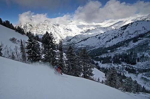
Skiing Peak 8,753
![Peak 9,001 & Peak 8,753]()
The ride down Rock Canyon.
Getting There
SUMMER:
Summer access via Squaw Peak Road between Provo Peak (left), Peak 8,753 (right).
During the summer, there is a 4WD road called "Squaw Peak Road" that travels right to the base of Provo Peak, Lion Head, and Peak 8,753.
Take I-15 to the 800 North Exit in Orem. Turn east onto 800 North, and continue up Provo Canyon. From the mouth of Provo Canyon, travel 1.9 miles and on the right you'll see an asphalt turnoff which is the road to Squaw Peak. Follow this road and it will split into two asphalt roads. The right fork goes to the Squaw Peak lookout and the left fork goes to Hope Campground. Go left. The road begins as asphalt, turns into a well-maintained dirt road, then transitions into a poorly-maintained, heavily-potholed, dirt road. Any good SUV or truck can make it. The road travels through Pole Canyon, then continues through the Provo Peak Basin to the highway in Hobble Creek Canyon. The road is open from roughly May 15th to November 15th. During its winter closure, the road remains accessible to snowmobiles.
To drive from Provo Canyon to the base of Provo Peak takes about 90 minutes. The dirt road has a nice lookout where is rises above the trees and you can see the entire Provo Peak Basin. It is an amazing view. When you've hit this lookout you'll know you're about halfway there. Follow this road until it meets with the base of Provo Peak's west ridge. From here you can hike Provo Peak, Lion Head, and Peak 8,753.
WINTER:

Winter access via Rock Canyon.
During the winter, the Squaw Peak Road is closed to cars, but if you have a snowmobile, follow the summer instructions detailed above to the base of Provo Peak, Lion Head, and Peak 8,753.
If you don't have a snowmobile, or would rather hike the mountain from the valley floor, use the following instructions to the Trailhead at Rock Canyon. Take I-15 to the University Parkway Exit in Orem. Travel east on University Parkway and stay on this road until you reach the intersection with 2230 North. Turn east (left) onto 2230 North and continue to the LDS Provo Temple. Once you arrive at the Provo LDS Temple, continue east on the road that passes the north side of the Temple. This is North Temple Drive. Continue directly east on this road all the way to the parking lot at the mouth of Rock Canyon. There are multiple parking lots with a large restroom and pavilion area in the middle. The trailhead is obvious and travels up the mouth of Rock Canyon.
Continue up Rock Canyon 2.5 miles until to reach the Squaw Peak Road. Travel south on the Squaw Peak Road an additional 2.5 miles to the base of Provo Peak, Lion Head, and Peak 8,753.
Red Tape
No Red Tape that I know of. Just don't burn the forest down.Camping
Rock Canyon Campground is located at the top of Rock Canyon in the Provo Peak Basin. You can reach the campground by hiking up Rock Canyon, or driving the Squaw Peak Road. If you're looking for more adventurous surroundings, you can hike around and camp anywhere on the mountain you choose.External Links
Skiing Peak 8,753
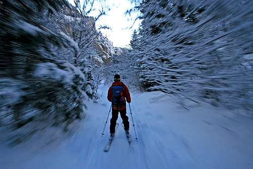
The ride down Rock Canyon.