
|
|
Mountain/Rock |
|---|---|
|
|
38.37999°N / 119.61443°W |
|
|
Alpine; Mono |
|
|
Hiking |
|
|
Summer |
|
|
11398 ft / 3474 m |
|
|
Overview
White Mountain 11,398' is located north of Sonora Peak in the Sonora Pass Area. It can be confused with other mountains in California with the same name, including White Mountain on the Sierra crest north of Tioga Pass or White Mountain Peak the 14er that tops the White Mountains across Owens Valley from the Eastern Sierra.
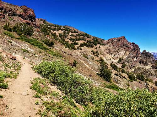
The White Mountain referred to on this page is essentially a big west sloping north/south ridge a few miles north of Sonora Pass. It's one of the highest peaks in the area. Only Leavitt Peak and Sonora Peak are higher. It has several minor summits along the way. The east face is glaciated and steeper but has a northeast and a southeast ridge that are fairly easy. Passing between Sonora Peak and White Mountain, the PCT (Pacific Crest Trail) offers easy access to the peak's southwest slope.
Appreciation is owed to Windsor Riley (aka Noondueler) who created this page, and who passed away in 2016.
Getting There
 Sonora Peak east slope
 FROM SONORA PASS: From the town of Sonora in the Sierra foothills take Hwy. 108 approximately 60 miles east to Sonora Pass. From the junction of Hwy. 395 eastern Sierra, go west 15 miles on Hwy. 108 to Sonora Pass. There is a designated parking lot. If starting from St. Mary's Pass to hit Sonora Peak first, drive another 2/3rds of a mile west on Hwy. 108 and take a right to an unmarked dirt trailhead. This is the St. Mary's Pass Trailhead.
FROM SILVER CREEK MEADOWS: From Sonora Pass go 11.2 miles east on Hwy. 108 to road 059 (a sign is posted SILVER CREEK ROAD PUBLIC ACCESS). From the junction with Hwy 395 go west 4 miles to road 059. The road is .3 miles east of the Marine Corps training center. This 2wd road switchbacks up 3 miles and meets Road 060 which goes west. Stay on Silver Creek Road 3/4 mile to a fork. Fork left and drive 1 mile to roads end. This is at 8,600' in Silver Creek Meadows. This is the same trailhead as used for Wells Peak.
Route Information
There are two routes from the Sonora Pass area and one from Silver Creek Meadows. Details to follow.
From Sonora Pass you can start at either the St. Mary's Pass Trailhead or the Sonora Pass Trailhead. The only reason to start from St. Mary's Pass is to combine Sonora Peak with White Mountain. If doing so, you'd take the PCT back to avoid going up and over Sonora Peak again. Or you can do this in reverse.
If taking this route, hike up St. Mary's Pass and follow all the way to the Sonora Peak summit, reached in a little over 2 miles. Drop down to the saddle, which is rather straightforward. Then follow directions below. It is 5 miles to the summit via this route.
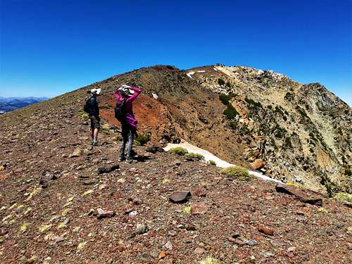
If bypassing Sonora Peak on the ascent, start at the PCT Trailhead. Take the PCT north as it climbs around the east side of Sonora Peak and comes to a saddle between Sonora Peak and White Mountain for about 4 miles to 10,260' just northwest of Wolf Creek Lake. From the saddle go north and generally left. However, make sure to gain the ridge instead of cutting all the way left. That way, scree fields are avoided. While hiking this ridge, the goal appears to be a pyramid-shaped summit far to the left. However, the actual summit isn't that far to the west. It is almost 6 miles one way to the summit via this route.
A loop can be done, which is recommended to start up St. Mary's Pass to Sonora Peak, and then down to the saddle and back up White Mountain. On the return, once the PCT snakes in front of the south face of Sonora Peak, the trail continues to the west, and then cuts back to the east. Instead of continuing to the east back to the PCT trailhead, just cut down the ridge. St. Mary's Pass Trailhead is less than a mile away. This saves about 1 3/4 miles of hiking (including hiking along Hwy. 108).
From Silver Creek Meadows, head south up the hillside until you reach a road. Follow the road as it stays in the forest for 1 1/2 miles, and seems to end right under the ridgeline after gaining over 1,000'. From here, the main peak is approximately 2 1/2 miles and 2,000' to the northwest via the northeast ridge which is class 1/easy class 2.
Red Tape
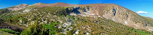 White Mtn. pano from the southwest, from the PCT
Hwy 108 gets quite steep as it approaches Sonora Pass from east or west with hairpin turns especially from the east. It is not recommended for RVs or trailer trucks. White Mountain is in the Carson-Iceberg Wilderness and no permits are required for day hiking. Permits are required for overnight camping. Permits can be obtained from the Bridgeport Ranger District just south of Bridgeport on Hwy. 395, 760-932-7070, 8 am to 4:30 pm 7 days a week in the summer. Mon. through Fri. in winter. Or write: Cheryl Probert, District Ranger HC 62 box 1000 Bridgeport, Ca. 93517
Camping
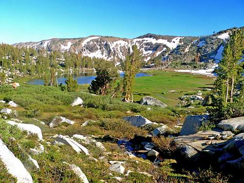 Wolf Creek Lake from the base of White Mtn. west slope
CAMPGROUNDS IN THE VICINITY: EUREKA VALLEY: 28 sites, el. 6000', along Hwy. 108 2.3 miles east of Dardenelles Resort and 2.7 miles west of Kennedy Meadows Road junction. BAKER: 44 sites, 6,250' at start of Kennedy Meadows Road junction. DEADMAN: 17 sites, 6,300', .5 miles along the Kennedy Meadows Road. CHIPMUNK: 7,950', along Hwy. 108, 4,7 miles east of Sonora Pass and 7.3 miles east of Hwy. 395. SONORA BRIDGE: 23 sites, 6,800', along Hwy. 108, 1.4 miles west of Hwy. 395.