
-
 11492 Hits
-
 81.18% Score
-
 13 Votes
|
|
Mountain/Rock |
|---|---|
|
|
44.05243°N / 10.23398°E |
|
|
Hiking, Scrambling |
|
|
Spring, Summer, Fall |
|
|
5213 ft / 1589 m |
|
|
Overview
 Monte Altissimo seen from Monte Sumbra Monte Altissimo seen from Monte Sumbra |
Marble has been the wealth of the coastal towns of Massa and Carrara on the Tyrhenean shoreline for the better part of the last 2000 years. In the backcountry of the two cities the limestone range of the Alpi Apuane rises to almost 2000m and many of the mountain cores are made up from marble. Of those mountains, Monte Altissimo can serve as a good example to showcase the history, a mountain which also has two demanding hiking (or scrambling) routes and thus deserves its place on SP.
 |  |  |
While marble quarrying already started in pre-Roman times the first real marble works got only established during the Renaissance. It was Michelangelo himself, who created one of the first quarries at the base of the south face of Monte Altissimo to dig for the stuff to create his busts and statues. Later with the invention of dynamite the quarries in the area quickly expanded though it became evident that the explosions created to much debris among the valuable rocks. Finally, with the advent of diamond saws and high pressure water devices the marble could be cut into neat cubic blocks enhancing the efficiency so much that may of the quarries with lower quality rock (or difficult access routes) got abandoned. On Monte Altissimo there are at least three abandoned quarries in the east face, through which one of the ascent routes to the mountain runs. From afar these quarries look like wounds in the slope of the mountain.
 |  |  |
Monte Altissimo is a three pointed pyramid which dramatically rises above the town of Massa. Though its overall height amounts to less than 1600m the mountain possesses a south-west face which drops vertically for 700m into the valley underneath and which at its base is about one kilometre wide. The three ridges point to the west, east and south and are very steep. Of the two hiking routes which lead to the top, the south ridge route is the easiest since it follows fortification trails which were established at the end of WW II when the area saw some heavy fighting. The west ridge route follows the knife-edge crest but then traverses the very exposed north face of the mountain, circumventing the steepest part of the ridge. Both routes can be combined into a loop which is demanding but which can be completed in little more than four hours.
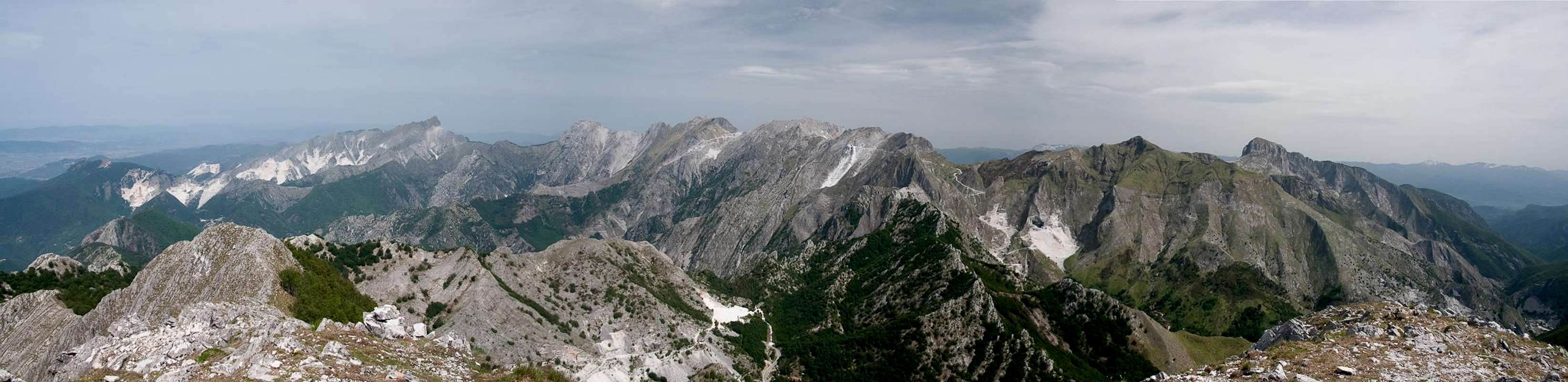
 The 700m Monte Altissimo south face
Thanks to its rather solitary location, Monte Altissimo also commands excellent views across the mountains of the Alpi Apuane with their towers, spires, faces - and marble quarries. On good days the views reach towards the Appennine main ridge in the east and the island Elba and Corsica in the Tyrhenean Sea.
360° Summit Panorama
  |
Getting There
 |
You can reach the trailhead at Ristorante Le Gobbie either from Massa or from Castellnuo di Garfagnana. Both towns are connected by a narrow mountain road which runs through Val Torrente Turrite Secca. If you are staying in one of the larger cities of Toscana (Firenze, Lucca, Pisa), the shortest and easiest approach is via Massa, which can be reached by the coastal motorway A12. Castelnuovo can be reached by SS12 and SS 445 from Lucca.
- From Massa on the Tyrhenian coast
- Take SP5 to Passo del Vestito
- Take SP13 into Val Torrente Turrite Secca.
- After a few km you reach a turn in the road with the Ristorante on the left hand side. Parking on both sides of the road.
- Take SP5 to Passo del Vestito
- North: From Castelnuovo Garfagnana
- Take SP12 direction Massa
- Shortly before you reach Passo del Vestito in a right hand turn of the road is Ristaurante le Gobbie with parking lots on both sides of the road.
- Take SP12 direction Massa
Red Tape
LINK TEXT HEREThe Parco Naturale delle Alpi Apuane was established in 1985 to protect the nature as well as culture of the area within which the Alpi Apuane are located. Its overall size amounts to almost 21000 ha. A constant challenge is the presence of roughly 300 marble quarries which their impact on the environment. A hiker might easily find himself inside one of the quarries and is requested to follow signs and rules there (especially for the start of the western route).
The park's official website
Accommodation
Accommodation is relatively easy to find along the coast of the Tyrrhenean Sea. Viareggio, Massa, Carrara and La Spezia offer lots of hotel rooms as well as campgrounds. Either book them by travel office or go for a google search.On the other hand, to stay closer or within the range you can make use of Agriturismo, farms, which offer food and lodging. The site of the Natural Park has a selection of all kinds of accommodation of the area:
There are three huts near Pania della Croce: Rifugio Rossi at Uomo Morto, Rifugio del Freo at Foce di Mosceta and Rifugio la Fania above Pruno and Cardoso. You can find more information on the Alpi Apuane main page
Weather Conditions
Maps & Books
Maps
- Alpi Apuane - Garfagnana
Kompass Verlag
1:50000
ISBN: 3-85491-852-6
- Geological Map Parco delle Alpi Apuane
1:50000
L. Carmignani, P. Conti, L. Disperati, P.L. Fantozzi, G. Giglia and M. Meccheri
Maps Online
Books
- Tuscany North / Toskana Nord
Wolfgang Heitzmann / Renate Gabriel (translation: Gill Round)
Rother Verlag
ISBN: 978-3-7633-4812-1 (English)
ISBN: 978-3-7633-4115-3 (German)
- Guida al Parco delle Alpi Apuane
Edited by: Giuliano Valdes
Series: Guide Felici
ISBN: 88-88327-91-6
- Guida all’Alta Via del Parco delle Alpi Apuane
Angelo Nerli
Felici Editore Srl
ISBN: 88-6019-006-1