Aug 11th, 2017 Started to modify the page and the other sections.
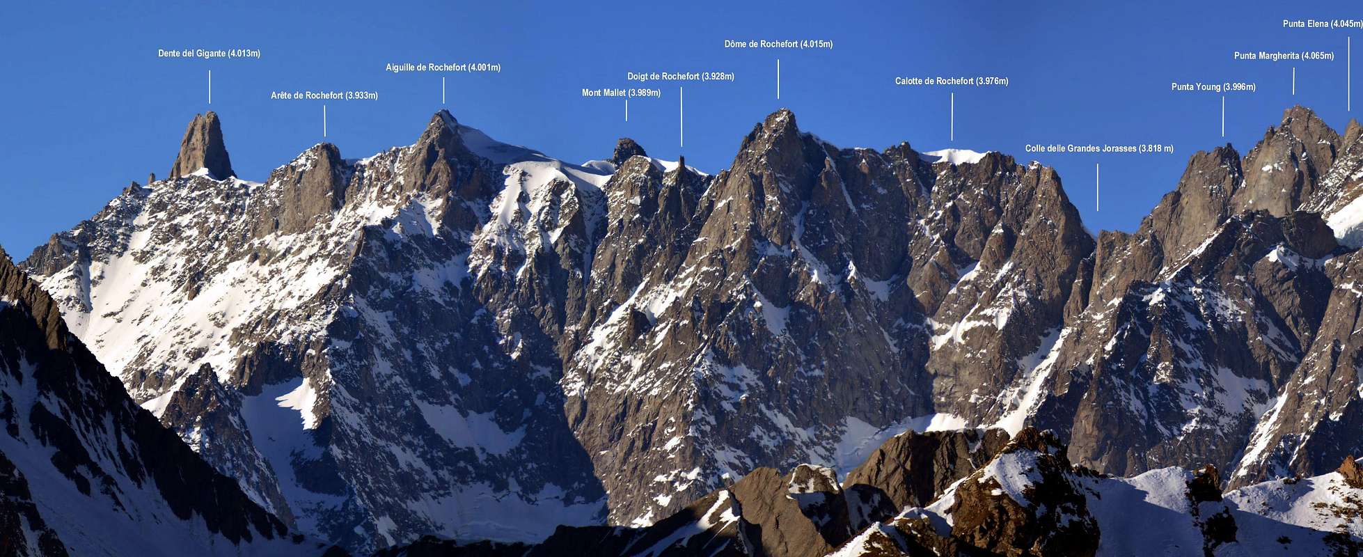
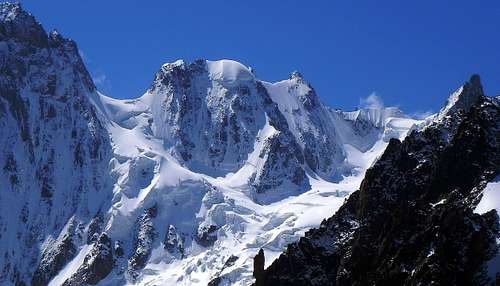
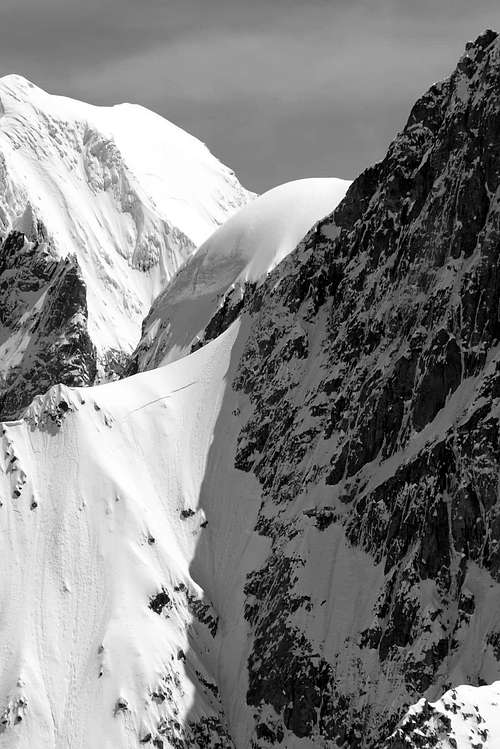
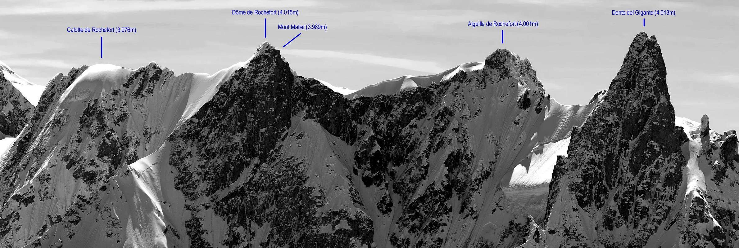
The Dôme de Rochefort, with its (4.015 meters) is the highest and also the most goodlooking peak of the whole "Rochefort ridge". However, this it is less frequented than the more famous Aiguille de Rochefort(4.001m), which is located about halfway between the Dente del Gigante (4.013m) and the Colle delle Grandes Jorasses (3.818m) and closer to the refuge Torino (3.382m). In fact it's well known that 90% of the climbers that attempt the famous ridge route, use to stop it on the summit of the Aiguille de Rochefort.
Il Dôme de Rochefort, con i suoi (4.015 metri) è il più alto ed è anche il punto piu’ panoramico della Cresta di Rochefort. Tuttavia, questo è meno frequentato di quello più famoso Aiguille de Rochefort (4.001 m), che si trova a metà strada tra il Dente del Gigante (4.013 m) e il Colle delle Grandes Jorasses (3.818 m). Il 90% degli alpinisti utilizza il Rifugio Torino (3.382 m) come base d'appoggio per la salita alla Cresta di Rochefort.
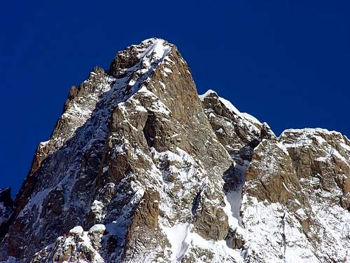
On its southern side a rocky spur falls almost for 1.000 meters, ending (3.053m) on the glacier "Plampincieux" and delimiting two high walls: east and west. The upper part of the peak is composed of excellent and very compact rock. On the French side it overhangs the "Glacier du Mont Mallet” with steep ice slopes. Dôme de Rochefort is generally reached during the crossing of the Rochefort Ridge, rarely from other routes. There are certainly more beautiful and highest peaks in the Mont Blanc group, but the Rochefort Ridge is unique in its kind (toghether with Midi-Plan and Biancograt). Aiguille and Dôme are in the list of the 4.000m of the Alps.
Sul versante meridionale una parete rocciosa cade quasi per 1.000 metri, terminando (3.053 m) sul ghiacciaio del Plampincieux delimitando altre due alte pareti, est e ovest. La parte superiore della vetta è composta da roccia eccellente e molto compatta. Sul lato francese si estende il Glacier du Mont Mallet con pendii ripidi di ghiaccio. Il Dôme de Rochefort è generalmente raggiunto durante l'attraversamento della Cresta di Rochefort, raramente da altri percorsi. Ci sono certamente più belle e più alte vette del gruppo del Monte Bianco, ma la Cresta di Rochefort è unica nel suo genere (insieme a Midi-Plan e Biancograt). l'Aiguille e il Dôme de Rochefort sono nell'elenco dei 4.000 m delle Alpi.
First Ascents
First on the Summit: James Eccles, Michel and Alphonse Payot, (Aug 12th, 1881).
SW Ridge: Karl Blodig and Max Horten, (Aug 09th, 1903).
NE Ridge: Jean/Reymond Leininger and Pierre Madeuf, (Aug 04th, 1937).
Routes Dôme de Rochefort 4.015m
NE ridge: - From Col des Grandes Jorasses - PD.
SW ridge: - From Aiguille de Rochefort - PD+.
SSE ridge: - From refuge Boccalatte and Glacier de Planpincieux - III°.
Ski route: - From refuge de Leschaux-Glacier du Mont Mallet-SW ridge - OSA/PD+.
Routes Calotte de Rochefort 3.976m
There are also two more elevation in the nearby of the Dôme: Ci sono anche altre due importanti altitudini nelle vicinanze del Dôme:
Doigt de Rochefort(3.928m)
Calotte de Rochefort(3.976m)
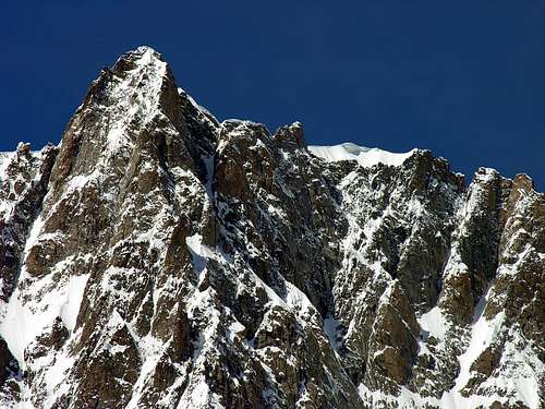
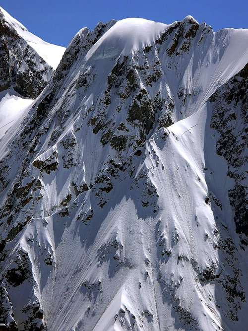
It is situated on the main ridge between the Dôme de Rochefort and the Col des Grandes Jorasses. Third component of the "Rochefort Trio", it's the lowest and the less showy of them. On the northern side presents a rock wall streaked with ice, 400 meters above the Glacier du Mont Mallet. It extends towards north-north-west with a ridge that becomes clear in its lower half and ends with a triangular rocky crag. Its southern side, totally rocky, overhangs the Plampincieux glacier for about 500 meters, with a great rampart, slanting gullies carved by two couloirs and as many rocky outcrops. The east one of them is the most obvious, and will be referred as "First tower". The top of the Calotte is covered by a thick ice cap, but almost invisible from the south, looming large when viewed from the north. By a strange coincidence the routes of the northwest ridge and the southern side were opened on the same day by two different rope partys.
Calotte de Rochefort north side
Si trova sul crinale principale tra il Dôme de Rochefort e il Colle delle Grandes Jorasses. Terzo componente del "Trio Rochefort", è il più basso e meno appariscente di loro. Sul versante nord presenta una parete di roccia e ghiaccio di circa 400 metri sopra il Glacier du Mont Mallet. Si estende verso nord-nord-ovest con una cresta che termina con una grande roccia triangolare. Il suo lato meridionale, totalmente roccioso, sovrasta il ghiacciaio di Plampincieux per circa 500 metri, con un grande bastione, inclinate gole intagliate da due couloirs e da tanti affioramenti rocciosi. La parte orientale di questi è la più ovvia, e sarà indicata come "prima torre". La cima della Calotte è ricoperta di ghiaccio, ma poco visibile dal versante sud, ma ben visibile da nord. Con una strana coincidenza le vie del crinale nord-occidentale e della parte meridionale furono aperte lo stesso giorno da due cordate diverse.
SW ridge: - From Dôme de Rochefort - PD.
NW ridge: - From Glacier du Mont Mallet - D.
North wall: - From Glacier du Mont Mallet - TD.
S side/E ridge: - From refuge Boccalatte-Glacier de Planpincieux-Col des Grandes Jorasses - AD+.
Routes Doigt de Rochefort 3.928m
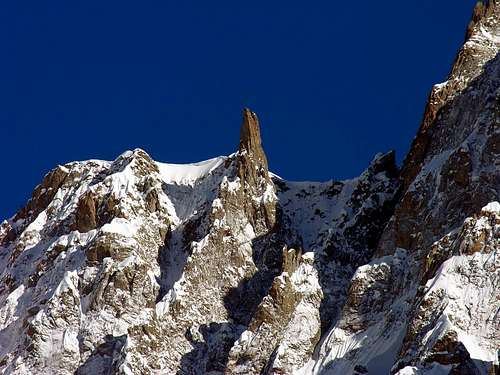
Elegant square tower that rises about 25 meters off the main ridge between the Aiguille de Rochefort and the Dôme de Rochefort, but closer to the second. It is placed few meters away from the edge of the ridge, on the Italian side. On this side (south), it originates a very sharp ridge at first, then larger, down to the glacier Plampincieux. It is usually avoided during the crossing of the Rochefort Ridge.
Elegante torre quadrata che sorge a circa 25 metri dal crinale principale tra l'Aiguille de Rochefort e il Dôme de Rochefort, ma più vicino al secondo. Si trova a pochi metri dal bordo del crinale, dalla parte italiana. Da questo lato (sud), origina una cresta molto affilata, fino al ghiacciaio Plampincieux. Di solito viene evitato durante l'attraversamento della Cresta di Rochefort.
North wall: - From the Rochefort ridge - 25m III°
S ridge: - From Glacier du Planpincieux - III°/IV°
The famous ridge...
The structure of the Rochefort Ridge is just as remarkable as the famous ridge of Piz Bernina's "Biancograt". First, it must be determinated, based on objective conditions, if climbers want to continue the climb over the Aiguille up to the Dôme de Rochefort. In this case they have to program for 7 hours the round trip return, which should be made as soon as possible because the soft snow greatly increases the risks. The decision, however, can also take from the Aiguille de Rochefort when climbers arrive, if weather conditions are stable.Other chance in case of bad wheather is continue to the Col des Grandes Jorasses escaping rappeling down to the Planpincieux glacier and the Boccalatte hut (not very confortable route). Or otherwise carry on over de Col de Grandes Jorasses to the bivouac Canzio and the summits of Grandes Jorasses group.Although the crest of Rochefort has not particularly difficult techniques, his path requires technical skill of the rope, ice axe and crampons, and the good experience of the western Alps. "Absolut absence of dizziness!!"
La struttura della Cresta di Rochefort è imponente come la famosa cresta del "Biancograt" del Pizzo Bernina. L'ascensione, deve essere determinata, in base a condizioni oggettive, se gli alpinisti desiderano continuare la salita dall'Aiguille de Rochefort (3h'15/4h'30 dal rifugio Torino, la discesa richiede lo stesso tempo della salita) al Dôme de Rochefort, il tempo totale di salita e discesa dell'intero itinerario richiede circa 14h'00. Il percorso dovrebbe essere in ogni modo fatto il più breve tempo possibile perché la neve morbida aumenta notevolmente i rischi. La decisione, tuttavia, si può anche prendere dall'Aiguille de Rochefort, se le condizioni meteorologiche sono stabili. Sebbene la cresta di Rochefort non presenti tecniche particolarmente difficili, il suo percorso richiede l'uso di corda, ramponi, picozza e casco si raccomanda inoltre una buona esperienza alpinistica e "Assoluta assenza di vertigini".
Refuges and Bivouacs
From Italy: Refuge Torino (3.375m): From the village of La Palud (Courmayeur), take the cable car that in 3 tracks takes easily to the refuge. Also by path but long and not recommended. Refuge Torino is a big refuge with 180 places open from the begin of june to the end of september. Tel +39-0165/844034. Website: www.rifugiotorino.it
Refuge Gabriele Boccalatte (2.803m): From the hamlet of Plapincieux (1.579m Courmayeur) take the path n° 21 that take in 4 hours to the hut. The building was a proper hut untill 1 year ago, open only during summertime. Now it's used as bivouac and open permanently. 25 places - no stove.
Bivouac Ettore Canzio (3.810m): The bivouac is placed in the nearby of the "Punta Young" and above the "Col des Grandes Jorasses". It can be reached from France or from Italy along tough routes. For the aproach check the pages of Grandes Jorasses routes. 8 places - open permanently.
From France:Refuge de Leschaux (2.431m): From Montenvers get down to the glacier using the iron ladders 5 minutes over the rail station. When the glacier divides in two, follow the left branch (glacier de Leschaux) pointing the foot of the Grandes Jorasses north wall. Before the glacier increase in steep the small hut should be visible on a rocky wall more or less 80m above the glacier (your left). Same ladders and ropes helps to approach. (3h'30/4h'00 hours from Montenvers). Open from mid june to mid September-24 places-tel. +33/686123149.
Mountain Conditions
You can get meteo information at the official site of the Regione Valle d'Aosta:
"Guida delle Alpi Occidentali", di Giovanni Bobba e Luigi Vaccarone C.A.I. Sezione di Torino Volume II (parte II), 25 Maggio 1896.
"Guida dei Monti d'Italia-Monte Bianco" (Vol. II°) di R. Chabod, L. Grivel, S. Saglio, G. Buscaini-Club Alpino Italiano/Turing Club Italiano, 1968 (in Italian).
"Rifugi e Bivacchi della Valle d'Aosta, Massimo Martini e Luca Zavatta, Ed. Editrek e l'Escursionista Editore, Febbraio 2012.
"neige, glace et mixte" le topo du massif du Mont-Blanc, Tome 1, du bassin du Trient au bassin du Géant di François Damilano.
"i 4000 delle ALPI" le vie normali di salita alle vette piu' alte d'europa, di Richard Goedeke, Guide Iter, Marzo 2003.
MAPS:
Kompass "Massiccio del Monte Bianco Valle d'Aosta Sentieri e Rifugi" Carta turistica 1:50.000.
I.G.C. Istituto Geografico Centrale Torino "Massiccio del Monte Bianco" (n° 4), Torino, 1998 1:50.000.
I.G.C. Istituto Geografico Centrale Torino "Monte Bianco-Courmayeur-Chamonix-La Thuile" (n° 107), 1:25.000.
Children refers to the set of objects that logically fall under a given object. For example, the
Aconcagua mountain page is a child of the 'Aconcagua Group' and the 'Seven Summits.' The
Aconcagua mountain itself has many routes, photos, and trip reports as children.
Parents refers to a larger category under which an object falls. For example, theAconcagua mountain page has the 'Aconcagua Group' and the 'Seven Summits' asparents and is a parent itself to many routes, photos, and Trip Reports.

 14897 Hits
 91.14% Score
 34 Votes