
-
 14184 Hits
-
 84.27% Score
-
 18 Votes
|
|
Mountain/Rock |
|---|---|
|
|
39.32182°N / 106.16973°W |
|
|
Hiking, Mountaineering, Scrambling, Skiing |
|
|
Spring, Summer, Fall, Winter |
|
|
13672 ft / 4167 m |
|
|
Overview
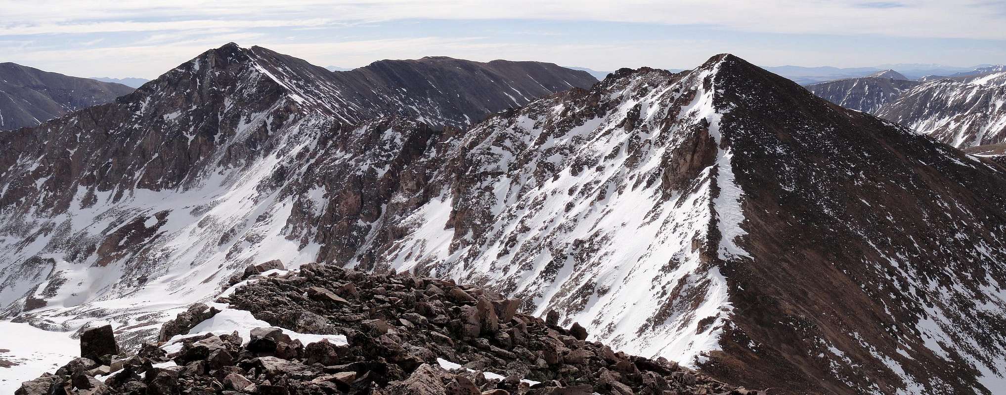
Mount Tweto is located in the Mosquito Range just to the west of the centennial Mount Buckskin and at the head of Mosquito gulch to the south and the Arkansas River drainage to the north. This aesthetic peak is well worth a climb and its tiny summit offers a commanding view of the Tenmile/Mosquito, Front and Sawatch Ranges. For those looking for a fun scrambling adventure, the traverse from Buckskin to Tweto is a long and sustained Class 3 traverse. The more you stay on the ridge crest, the more exposure you will have. Be sure you know what the weather is doing before embarking on a long climb anywhere in Colorado, including this peak. Mount Tweto Mount Tweto |  Mosquito Gulch Mosquito Gulch |  Traverse to Buckskin Traverse to Buckskin |  Mount Buckskin from Tweto Mount Buckskin from Tweto |
Getting There
Mosquito GulchThe Mosquito Pass road is the primary access point for Mount Tweto as well as neighboring peaks like Treasurevault Mountain, Mosquito Peak, Repeater Peak, and London Mountain.
The best place to start a climb of Tweto is along the Mosquito Pass Road (CO Road 12) high in Mosquito Gulch. From Denver, drive to the small town of Alma by either taking Highway 285 to Fairplay and heading north on Highway 9 for six miles OR by taking I-70 west to the town of Frisco where you take the CO Highway 9 exit south and over Hoosier Pass. From the summit of Hoosier Pass, continue six miles south to Alma.
From Alma, there is a small sign for CO Road 10 (Park Hill Road) heading west off the highway from the south end of town. Make sure you are not heading west on the road to Kite Lake. The Mosquito Pass/CO Road 10 turn-off is only 1000 feet south of the Kite Lake road turn-off. If you are coming from the south, you can also turn west onto CO Road 12 a mile south of Alma. CO Road 10 and 12 meet just a small distance west of Highway 9.
Both of these roads are graded dirt and kept in good condition. From where these two roads meet a couple miles from the highway, continue west on CO Road 12 towards Mosquito Pass (CO Road 10 ends). Continue on the good road for about 5 miles and park just off the road at 11,500 feet in elevation right before the road makes a 90 degree left turn and crosses Mosquito Creek. Beyond this the road is much worse and takes you further away from Tweto. Keep in mind this road is closed in the winter somewhere near Highway 9 and would make this approach about 5 miles longer walking or skiing the road, maybe more.
 Mosquito Gulch in fall Mosquito Gulch in fall |  Wildflowers in Mosquito Gulch Wildflowers in Mosquito Gulch |  Mosquito Gulch in winter Mosquito Gulch in winter |
 Mosquito Gulch near Cooney Lake
Alternate trailheads for Mount Tweto would include the Kite Lake trailhead where a climb of Buckskin by the standard route followed by the class 3 traverse to Tweto makes for a long day.
Arkansas Amphitheater
If you have a tough 4WD drive vehicle, Tweto can also be climbed from the north from the head of the Arkansas River. I will call this valley the Arkansas amphitheater for this page however it remains unnmaed. From Fremont Pass off Highway 91 descend south to a large switchback in the road where you will see a dirt road heading ESE. This turn-off is near an odd building. This small road becomes rough quickly. Follow it for 1.25 miles where you will see the long NE ridge of Arkansas to the south towering above you. From here, at 11,400 feet, a small and very rarely traveled road heads right (south) and climbs steeply. Going straight and continuing on the better road follows the Arkansas River more closely and ends after another half mile or so. If you value your vehicle it is best to park at this junction, however if your vehicle is modified and NARROW (wide trucks WILL NOT work) you can continue up this very narrow and rough road which crosses a small creek over two boards. These boards will hold the weight of your vehicle but are only suited for narrow wheel-beds. Beyond this small bridge the road opens up a bit and climbs high up into the Arkansas amphitheater through open tundra to its end at a swampy area at the base of the impressive north face of Mount Tweto. It is best to walk this road.
 Junction 91 South Junction 91 South |  Arkansas River from 4WD Road Arkansas River from 4WD Road |  Just above sketchy bridge Just above sketchy bridge |  Looking down the Arkansas Looking down the Arkansas |
Route Options
South Slopes - Class 2From the Mosquito Gulch Trailhead described above, walk north on an old road (tough 4WD can drive) for about 2 miles as it switchbacks up the valley where it ends below the steeper south slopes of Buckskin and Tweto. From here, walk northwest up talus for about 0.7 miles and 1100 feet up until you reach the summit marked by a small wooden pole and a pile of rocks.
Arkansas Headwaters/North Ridge - Class 3
There are a few ways to climb Tweto from the north. From the end of the rough 4WD road described above, climb WSW over tundra and rocks to the base of the very loose talus slope that leads to the Arkansas/Tweto saddle. This slope goes up 500 feet but will be miserable. There are many other slopes on the Ease side of Arkansas further north that can also be ascended to also include a traverse over Mount Arkansas (See map). From the saddle between Arkansas and Tweto, head south up the ridge to the summit of Tweto. An occasional class 3 move will be required.
Buckskin/Tweto Traverse - Class 3
Buckskin and Tweto can be climbed together by a long sustained class 3 ridge. Plan on at least an hour (one way), likely more to traverse this ridge. See This Page for more details about this traverse.
Tweto can also be traversed easily from Treasurevault Mountain with class 2 walking. Mount Arkansas is usually done with Tweto by the short class 3 traverse between them.
Maps
 Arkansas Headwaters (North) Routes
 Mosquito Gulch (South) Routes
Red Tape/Camping
No red tape here. Leave No Trace principles apply. Camp wherever you decide to park. Backpacking in this area doesn't make much sense. Be weary that some of the nearby area especially lower down in the headwaters of the Arkansas River lie on the Climax property. Arkansas River Headwaters
External Links
 Mount Tweto
Trip Report Mosquito Gulch Circumnavigation
Weather Forecast
Avalanche Forecast
Lists of John
Climax Mine Recently Reopened
City of Leadville