
|
|
Mountain/Rock |
|---|---|
|
|
38.31360°N / 117.2425°W |
|
|
Nye |
|
|
Hiking |
|
|
8530 ft / 2600 m |
|
|
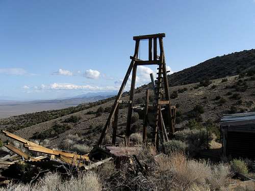
Mine near trailhead
Overview
Not to be confused with San Antonio in Texas, this San Antonio is a rarely visited mountain range located not too far north from Tonopah. Mining was the reason why this area was even on the map and the earliest miners arrived in 1863. The name San Antonio is reported to have been given by a J. P. Cortez who was the owner of first mine in the area called "The Libertad". A stop on the stage lines was also opened nearby and a post office was present from 1873 to 1888. Not much remains today but scattered about the area structures can still be found that make you realize that mining was once the mainstay of this part of Nevada. See history section below for more.The San Antonio range itself is a relatively small mountain range and has very little appeal to hikers and climbers. Its main attraction is the range highpoint, sought after by those who chase peaks that have a prominence of over 2000', of which the San Antonio Range HP ranks number #114 on the list of Nevada prominence peaks.
 Gate off of highway 376 Gate off of highway 376
|  About 4 miles in About 4 miles in
|  Mine Mine
|
Getting There
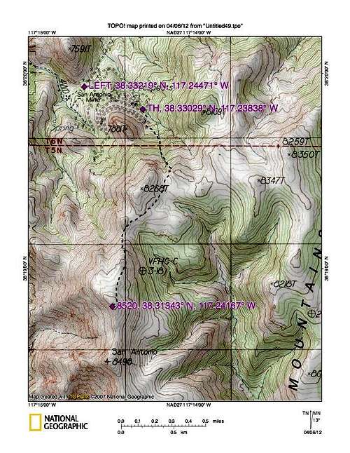
From Tonopah, head east out of town on US 6 and after five miles or so, turn north on NV 376. After close to 26 miles from the junction with US 6 and NV 376, watch for an unsigned dirt road on the left. (see my map for waypoint)You will need to open and close a gate and a large blue water tank was located just to the right of the gate. A good dirt road will head southwest for about 2 miles and drop into a wash. A dirt track leading up and out of the wash will be noted heading uphill just to the right as the road you are on begins to curve to the left towards a large tank structure located further east along the wash. The dirt track is a bit rough as you get up and out of the wash. See my map for waypoint. It is now almost 6 miles to a road that will take you up to where we parked. Again, see my maps for waypoint. This road gets steadily rockier as you head toward the range and at some points, high clearance is a necessity. I'd also recommend 4WD. A 2WD vehicle with low clearance could be driven to within about 3 miles of the TH that we used but I wouldn't attempt to get much closer with that kind of a vehicle.
We were able to park near an old mining structure where there is a small turnaround and parking suitable for a vehicle or two. This was at an elevation of about 7300'.
Key waypoints (lat/long nad 27)
Highway turnoff 38.4275 117.1917
Wash 38.4008 117.2036
Road get rough 38.3792 117.2299
Key left turn 38.3324 117.2456 elev 7360
Between where the road gets rough and the key left turn that heads up to where we parked (see route map), a low clearance vehicle becomes a liability. The road gets rocky and there are places where minor washouts have occurred. This is also cattle country so be aware of cattle on the road on the way in.
 Trailhead Trailhead |  First slope First slope
|  halfway to the summit halfway to the summit
|
Red Tape
This is BLM land and as far as I could tell there is no "red tape" to be concerned about. A word of warning, the road can be rough and rocky and I wouldn't go beyond where your comfort level in driving on rough unmaintained roads is reached. Also, do not venture into mines or mine shafts, they can be very dangerous.For more information, contact the BLM office in Tonopah
Tonopah Field Office
1553 South Main Street
P.O. Box 911
Tonopah, NV 89049
Phone: 775-482-7800
Fax: 775-482-7810
Office hours: 7:30 am-4:30 pm, M-F
 Summit ahead Summit ahead
|  Me on the top Me on the top
|  Looking north Looking north
|
Camping
No organized camping is available but you could car camp in several places and it is recommended that you observe the "leave no trace" ethics. There is no water available and you will need to be self sufficient in this type of area. Also, pack out any garbage you might generate. Not a bad idea to let friends and family know where you are going to be.Motels are available in Tonopah.


Route

Trailhead
From where we parked near the mine, Ken Jones followed this route up to the summit: Follow the old mining road to its end and then head south up a fairly steep gully and head for a saddle area located at 8100 feet. Head southwest from and traverse to the southeast side of point 8268 aiming for a saddle at 8180 feet. From here, just keep heading south up the ridge to a plateau where the summit comes into view not too much further to the south. The highpoint contains a cairn and a glass bottle register. From where we parked, it is only a mile and a half with 1200 feet of gain to get to the high point.
See Ken Jones trip report posted on peakbagger.com for more on this and a GPS route. While I drove to the beginning of this hike with Ken, I didn't do the hike to the summit due to some concern I had about lower back pain I was experiencing at the time. Ken took only 2 1/2 hours round trip which included time at the summit.
If you want to make a real hike out of this one, see the trip report posted on peakbagger.com by Brad Boeser. He hiked it all the way from the highway.
Weather
Be sure to have a vehicle that is in good condition, plenty of gas, water, food etc. Let people know where you are going and when you expect to be back. Cell service is spotty so don't count on having any coverage. High clearance was necessary and a spot or two required 4WD during our visit. Avoid this area during thunderstorms and heavy rain as the roads could become impassable. Also watch for cattle as this is active rangeland.
Click for weather forecast

Click for weather forecast
Summit Register
To me a summit register captures a bit of history during the time it resides atop a mountain. The register on San Antonio's high point dated back to 1988 when it was first placed by Andy Zdon, the author of the book "Desert Summits" which is now in its second edition.I always like to take pictures of the register if its not visited very often as registers have a tendency to disappear and my pictures capture what had been entered.

Register
This is a seldom visited summit although the year 2013 saw many visitors but this is a rare situation. Here's a rundown of what I have for this mountain through 2013:
1988 - Andy Zdon and Russ Weston
1989 - Mark Vollmer
1990 - Gordon MacLeod and Barbara Lilley. Also an entry from a guy from Wyo.
1999 - John Vitz, Barbara Sheets and Donna O
2000 - Mark Adrian
2002 - Tom Roundtree
2011 - Brad Boester
2012 - Bob Sumner in January and Ken Jones in March
2013 - Dennis Poulin and myself. Then came Richard Carey, Bob Packard,
Andy and Sarah Martin, and Adam Helman.
That's 21 visitors over 25 years with a huge 9 year absence between 2002 and 2011. See Brad Boester's peakbagger entry as he did it from highway 376.
 Register Register
|  Register
|  Register Register
|
History
Thanks to ghosttowns.com for the following:"San Antonio was a major stop on the Westgate-Ione-Belmont stage line built around a group of springs. As early as 1845 Fremont had stopped at the springs on his way to meet Kit Carson. After gold was discovered in the nearby San Antonio Mountains, the stage stop became a small town as miners began to move to the district. A two story station/hotel was built in 1865 and an addition in 1879. The town had a fairly large business district and a population of around 100. The district’s main mine was the Liberty and when it closed in 1868 the population dropped to around 50. But the stage station was still an important stop for travelers heading for new strikes and to southern Nevada. During the early 1890s San Antonio almost became a ghost town with only an occasional traveler stopping at the station. Soon all stage lines stopped running through San Antonio. The town came to life again in 1896 when new strikes were made that led to an increase in stage travel. But then train tracks came to the boomtowns ending stage travel overnight. All that remains of the once impressive stage station are the crumbling walls and smaller ruins from the business district. Submitted by: HBC"
Legends of the west - A chance encounter
Some of the most prolific peakbaggers I know are involved in county highpointing and prominence peak bagging. Little did I know that when Dennis and I were heading back to the highway after hiking to the top of San Antonio's summit, we would literally meet four of them as they were heading in to do the same mountain we had just left. As we (Dennis and I) got to within about two miles of the highway, we noticed three vehicles heading our way in the wash area. It is really rare to encounter other vehicles while chasing these seldom visited peaks so seeing three vehicles seemed really unusual. I noticed that they had stopped and seemed to be surprised at seeing us approach in our trucks as well and then I noticed that one of the drivers was Andy Martin, a guy I had spent a week with in Utah a couple years before and he had his wife Sarah with him. Then I noticed Bob Packard and Adam Helman, in Bob's camper truck and I didn't know the driver of the third vehicle. That turned out to be Richard Carey, a guy Dennis had climbed Mount Rainier with a few years before. These guys represented a who's who of USA county highpointing and prominence peakbaggers.Bob Packard is one of the most prolific peakbaggers alive and at the age of 77 he is still going strong. Richard Carey, Andy Martin and Adam Helman are also very very active and are three more of the best. Throw in Dennis and you have 5 of the top peakbaggers in the western USA. Check out this page on lists of John for a capture of where these guys stand in prominence peakbagging - Click here for that list. You might even see my name on that list and as Adam Helman put it, in our chance meeting, we had 6 of the top prominence peakbaggers of the USA. We had a great reunion and decided to spend what remained of the afternoon and evening camping together and swapping stories.
Bob Packard and Adam Helman have both completed every county highpoint in the western USA while Bob, Adam and Dennis have completed the 57 Ultra prominence peaks, no easy task. Bob is 77, Richard is 69, Dennis is 66, Andy is 60 and Adam is the youngster having just turned 50. The lists of their accomplishments in peakbagging is truly legendary so it was fun to have an evening together with all of them.
 4 of the best 4 of the best |  Like a mini convention Like a mini convention |  Richard and Dennis Richard and Dennis |