
|
|
Mountain/Rock |
|---|---|
|
|
43.32140°N / 111.2908°W |
|
|
Bonneville |
|
|
Hiking |
|
|
Spring, Summer, Fall |
|
|
8952 ft / 2729 m |
|
|
Overview
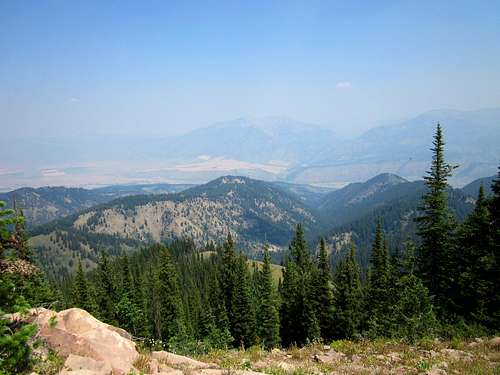
Red Ridge Mountain is found just to the west of highway 26 near the Palisades Reservoir in southeastern Idaho. As you drive by on the highway, there isn't really anything about Red Ridge that grabs your attention hence the lack of a photo showing the area from the road. Still, I found that it was a beautiful area and contained a great hike that allowed me to find the summit of this mountain.Red Ridge Mountain is attractive to peakbaggers who are interested in prominence or range highpoints. With a prominence of 2212', Red Ridge comes in as the 77th most prominent peak in the state of Idaho.
Getting There
From Idaho Falls, take highway 26 about 50 miles from the junction of highways 26 and 20 on the east side of Idaho Falls. Passing through Swan Valley, watch for the road that goes across the top of the Palisades Reservoir Dam and take the road that becomes FS 058 and go right at the junction and follow this nice road for a couple miles to where you park alongside the road.If you are coming from the south via Alpine, the turnoff at the top of the dam is about 18 miles. Then follow the same directions. You will note after crossing the dam, that the Calamity Campground is down a road to the left. You will continue up the washboarded road to the FS 058 junction and take the right fork as mentioned above.
 Parking Parking |  TH map TH map |  Route up Route up |
Route
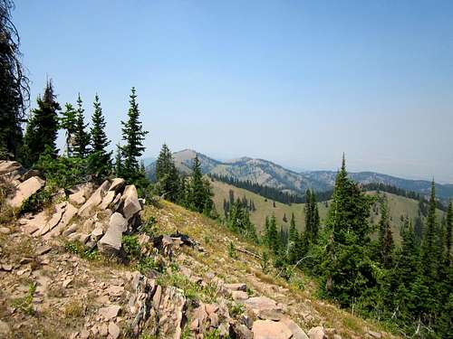
I followed Greg Jagielski's fine directions by using the Russell Creek trail that starts off as ATV trail 266, found just at a bend on FS 058. There was plenty of room to park off the road but no official trailhead. (GPS 43.3390 111.2323 5700')The trail starts off as an ATV track and after about a mile, becomes a trail and continues as such the rest of the way. I was surprised to see that every fallen tree had been cut so that the trail remained open the entire distance. I don't believe I had to step over one fallen tree the whole distance of my hike. The only tree that was an obstacle was at the very beginning and that will probably be gone when the hunting season begins.
I crossed one small stream near the two mile mark and soon after that the trail made 5 switchbacks up the hill (some steep trail sections in here) and then hooks up with another trail at the three mile mark. Take a left at the trail junction and follow it to where it becomes the Red Ridge trail and passes just below the summit. I left the trail at about the 8650 mark and just made my way the last bit steeply up the mountainside to the summit area.
The summit had a central benchmark and a small glass jar register nearby. I also found one witness benchmark and really didn't look for any others. Views to the east and north were good but trees blocked views in other directions.
I didn't see any indication that there had been anyone on any of the trails I covered and it could've been the last hunting season since anyone had been in the area making this a very lonely area for hikers. I had cell reception above the 7800' level and the company of one lonely snake that was crossing the trail when I was heading down.
Overall statistics: 9 miles round trip via the Russell Creek trail and at least 3300 feet of elevation gain. I enjoyed the trail and would recommend it as a good route to get to the summit of this mountain. I am sure there are other routes that are good but since this is the way I went, I can only speak from my own experience. Other than the last 350' to the summit after I left the trail, it was a trail hike the entire distance.
 Trail Trail |  |  |
 Sign Sign |  Russell Creek map Russell Creek map |  Looking back Looking back |
Summit
While the summit isn't spectacular, it is a fitting end to a upward hike that takes you through some nice forest and gives you a feeling of accomplishment. The fact that i saw no one else means that you will most likely have the whole area to yourself. Talk about a seldom visitedsummit, this one has had very very few. Rick Baugher has been to it twice, then only John Vitz, Bob Packard, Greg Jagielski and myself are only ones claiming this one to my knowledge.
 |  |  |

Red Tape
The peak is on National Forest land and I am not aware of any red tape.Targhee National Forest
SUPERVISOR ADDRESS
1405 Hollipark Dr.
Idaho Falls, Idaho 83403
208-524-7500
RANGER DISTRICT ADDRESSES
Ashton-Island Park
P.O.B. 858
46 Hwy. 20
Ashton, Idaho 83420
208-652-7442
Camping
Several campgrounds are available in the area and the one I stayed in for a couple nights was the Calamity Campground. Oriented to boaters and the RV/trailer set, there is a nice section for tent campers in the "C" section. Some of the campsites are first come first serve and some are able to be reserved. The camp hosts were friendly and helpful.The northern most campground of the Palisades Reservoir is named Calamity and can be reached by crossing the dam. With multiple loops hugging the steep sides of a ravine, camp sites with extra wide parking aprons for boat trailers, Calamity might be the most popular campground on the Reservoir. Views from most of the camp sites are delightful but best from Loop C, the steepest and highest loop in the campground. A huge boat ramp and parking area add to this campground's popularity.
For information on getting a reservation at Calamity, check this link.
There are other campgrounds nearby but I refer you to the National forest site for more information at this link.
Dispersed camping is available and I saw many places where people had camped off of the FS 058 road.
Weather
Alpine WyomingViews
Notes
Victor Zhou and I started off by climbing up South Putnam peak on Saturday and followed that one up by visiting the summit of Big Elk Mountain. After doing Big Elk, I was in the area so I stayed the night at the Calamity campground in loop C while Victor made the long drive back to Salt Lake City. The hike up Red Ridge was a logical choice since was close to the campground and was another Idaho prominence peak. My last peak in the area before I returned home was Black Mountain which is south and west of Alpine Wyoming. The air conditions of this usually pristine area was awful, almost like being in Los Angeles thanks to the air pollution caused by all the Idaho fires. Still, I felt good about picking up 4 peaks in 4 days and look forward to getting back to this area for several more peaks that are on the Wyoming side of the Palisades - Alpine area.Pictures....With the smoky conditions we encountered, I am hopeful that one or more of you that have good pictures of this mountain will be willing to share them for the sake of this page. I took a lot of pictures but most are of smoky skies and are dull in appearence. The few pics I did put up don't really do this fine mountain justice.