
-
 6569 Hits
-
 75.5% Score
-
 7 Votes
|
|
Mountain/Rock |
|---|---|
|
|
44.32637°N / 118.87262°W |
|
|
Grant |
|
|
Hiking, Scrambling |
|
|
Summer, Fall |
|
|
8000 ft / 2438 m |
|
|
Overview
Berry-Norton* lies in the Strawberry Mountain Wilderness in Eastern Oregon. Berry-Norton can be climbed as a cross-country hike and is ranked at #89 on the Oregon Top 100 Peaks at 8000+ feet of elevation. Berry-Norton lies two miles along a ridgeline extending southeast of Canyon Mountain, but the latest USGS map indicates Berry-Norton is slightly higher. Six other peaks located in this wilderness are also listed in the top 100 Highest Peaks of Oregon.The Strawberry Mountain Wilderness is located in the Malheur National Forest between John Day and Prairie City to the north, and Burns to the south.From the USFS website:"The complex geological story of this landscape began millions of years ago with the buckling of an ancient sea floor beneath the area where the western part of the Strawberry Range now rises. Much later, volcanic ash and lava formed the eastern part of the range. Most recently, the glacial ice carved its classic signature--U-shaped valleys--into the mountains. The ice also hollowed out the rock beds that today hold the seven alpine lakes of the Strawberry Mountain Wilderness--rare pleasures in the arid wilderness experience."From wilderness.net:"This high-country rugged Wilderness contains five of the seven major life zones in North America. Glaciation hollowed out beds in U-shaped valleys that today hold seven alpine lakes. Elevation ranges from about 4,000 feet to 9,038 feet atop Strawberry Mountain in the east-central portion. Large numbers of larch, the only conifer to lose its needles, turn to gold in fall, highlighting a forest of spruce, pine, and fir. Accenting the gold hues are wild strawberries that ripen to juicy redness in July, and mountain basins blooming with summer wildflowers. A native population of Rocky Mountain elk reside here with mule deer, antelope, black bears, cougars, mink, and beavers. Martens and hawks watch the wildlife action from on high."The Strawberry Basin Trail is the most popular hiking route up Strawberry Mountain, but other trails are much less used and away from their trailheads offer a significant sense of solitude, even during hunting season. Some trails are rocky and others had been obscured by recent wildfires and subsequent brush regrowth.
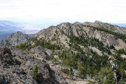 View of Canyon Mountain from Berry-Norton Summit
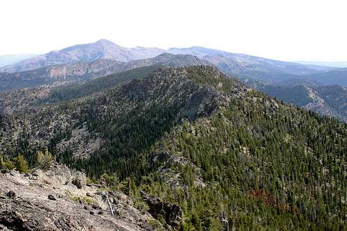 View East from Berry-Norton, Strawberry Mountain on left in the distance
Naming
[*] Jeff Howbert published a list of "Oregon's 100 Highest Peaks" in the May 1996 issue of Pack & Paddle magazine. Peaks on this list have at least 500 feet of "clean" prominence (rising at least 500 feet above any saddle connecting it to anything higher). Berry-Norton is still not named on the latest USGS 7.5 minute Pine Creek Mountain, OR map (1998). When Jeff created his list he named this peak "Berry-Norton" after two adjacent drainages, Berry Creek to the southwest and the Norton Fork of Pine Creek to the northeast.
Getting There
Berry-Norton can be accessed from the south via the Joaquin Miller Trail #219. From John Day, turn south on US highway 395 from OR highway 26. Continue through Canyon City and after 10 miles (near milepost 10C) turn left on County Road 65 (Canyon Creek Road, FR 15). Follow CR 65 3.0 miles and turn left onto FR 6510. Follow FR 6510 5.1 miles to the Joaquin Miller Trailhead at the end of the road. You will pass FR 812 at 1.7 miles.Berry-Norton should also be accessible from the west via the Canyon Mountain Trail #218, but I have no experience with that trail. The road to the trailhead is not maintained by the Forest Service, and it recommend 4X4s vehicles only during dry months of year.
Route
The Joaquin Miller Trail climbs to the top of Rattlesnake Ridge, then drops down into a lower ridge separating Berry and Tamarack Creeks. At 2.4 miles the Tamarack Creek Trail forks to the right. Continue on the Joaquin Miller Trail and climb about 2 miles to about 7000 feet, where a rocky outcropping above the trail on your left (to the north) appears and a rock buttress is on your right.
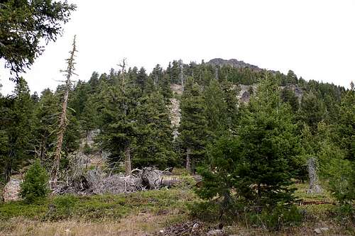 Leaving the Joaquin Miller Trail for Berry-Norton
Leave the trail here and climb directly up towards the rock outcropping about 600 feet, then traverse upward to the left to reach the top of the ridge at about 7800 feet. Traverse the ridge to the west, passing obstructions to the left, then climb up to the high point just above 8000 feet.
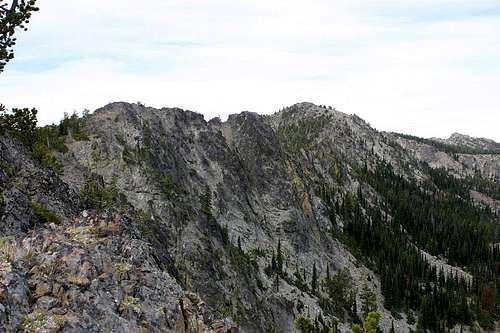 View of the Berry-Norton summit from the East Ridge
The summit is broad with several potential (dry) bivouac sites.
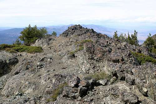 Berry-Norton Summit
Red Tape
According to this link, the Malheur National Forest does not charge a day use fee for trailhead parking.
When to Climb
July to October, depending on seasonal conditions.According to the Malheur NF website:In a normal year, most people use the Wilderness between July and November. Snow may be encountered at higher elevations any time of the year. The climate from September is mostly mild, with clear skies. Summertime thunderstorms may occur, usually in cycles lasting several days. Daytime temperatures normally range between 30 and 80 degrees Fahrenheit; nights are cool. Freezing temperatures can occur any time of the year.
Camping
Wickiup Campground is just off County Road 65 (Canyon Creek Road, FR 15) a few miles southeast of the junction with FR 6510. There is ample space for primitive camping at the Joaquin Miller Trailhead.