
-
 12647 Hits
-
 78.27% Score
-
 9 Votes
|
|
Mountain/Rock |
|---|---|
|
|
46.96988°N / 121.58223°W |
|
|
Pierce |
|
|
Scrambling |
|
|
Summer |
|
|
6620 ft / 2018 m |
|
|
Overview
Slide Mountain and South Slide Mountain are in the extreme northeastern corner of Mount Rainier National Park and form part of the Sourdough Mountains. The name comes from the obvious and enormous slide that removed the entire western flank of the mountain and deposited it in the valley floor. It must have occurred not too long ago, because the hardy vegetation that establishes itself on Northwest peaks has failed to start regrowing on in the slide area and even on the valley floor.
There is some confusion over what exactly is the true Slide Mountain. There are three points on the ridge which are alternatively designated "Slide" or "South Slide." The USGS labels the lower (6,339 ft.) northernmost point as "Slide Mountain," fails to label the highest middle point at all, and labels the southernmost peak as "Point 6,620." It is curious as to why the USGS would label the lower peak "Slide Mountain," especially as the major slide appears to be on the western flank of the highest point just south of it, referred to here in this report as "Point 6,220+." Could it be a mistake by the USGS, similar to other mistakes such as mislabeling the summits of Chikamin Peak and Mt. Daniel? The Mountaineers considers this highest summit as the true Slide Mountain. In the absence of definitive information to the contrary (Fred Beckey doesn't mention these peaks), one must go along with the USGS and call the lower 6,339 foot summit Slide Mountain, and the higher 6,620+ foot summit (with the actual slide on it) as South Slide Mountain.
This area is very popular, as the parking lot for the start of this climb is only a mile from the much-visited Sunrise Visitor Center. South Slide is probably climbed very often, while Slide, being farther north and guarded by unpleasant scree and talus slopes, not to mention being much lower, is probably not climbed that much at all. The appeal of this scramble is that one starts high and stays high. The final mile approach to South Slide is entirely along an alpine ridge with stunning views of Mt. Rainier rising over the Palisades on the west side, with views down to the green meadows of Bear Park on the east. Evidence of elk and bear "grace" the ridge ramble to these peaks. Beautiful flower fields will grace your hike through this area. It is rich in Lupine and Magenta Paintbrush. It is truly a magnificent area with much to offer.
Mt. Rainier is barely visible above the Palisades during this hazy, late-July afternoon. Marcus Peak in the foreground. Taken from South Slide Mountain. July 31, 2013.
Getting There
Drive SR-410 southeast from south of Seattle, heading through the towns of Enumclaw and into the Northeast gate of Mount Rainier National Park. In about five miles after the park entrance, find the turn-off to the White River Road. Pass through the Guard Station at the White River Road, and continue another 10.5 miles to a sharp bend in the road at 6100 feet. This is Sunrise Point. Park here in the large parking lot.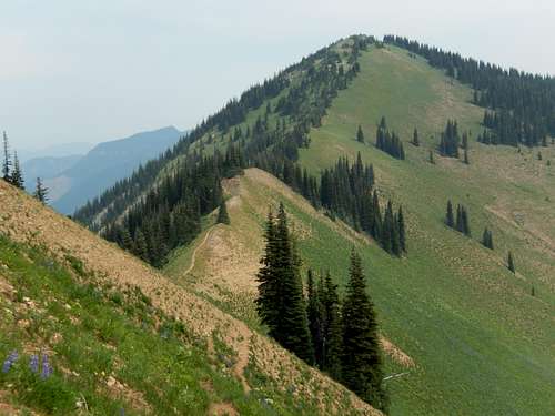
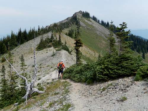
The False Summit of South Slide from Brown Peak. July 31, 2013.
Route
Find the trailhead of the Palisades Trail at the northeast corner of the parking area, and start your discouraging descent, losing 300 feet to Sunrise Lake in 1/2 mile. In another mile, reach pretty Clover Lake, as the trail makes inefficient ups and downs, losing elevation as quickly as it gains it. Another mile takes you past Tom, Dick, and Harry Lakes (camp at Dick Lake), and finally, the trail reaches its highpoint at a pass betweeen The Palisades to the Southwest and Brown Peak to the Northeast. This is 3.5 miles from the Sunrise Point trailhead.Look for a concealed (by a fallen tree) trail leading right (east) from the trail high point. This trail will steeply gain the West Ridge of Brown Peak, leading to a forested summit in about 1/2 mile. The best views will be lower down in the meadows. Great views of The Palisades are visible from here. Continue north from Brown Peak summit along the ridge top above Bear Park. There are many trails on top of and along the sides of the ridge top, presumably made by both humans and game. Go 1/2 miles from Brown and arrive at a summit area of grass and trees at roughly 6,600 feet. This is your first false summit. Continue another 1/4 miles to a summit that is cliffy on the east, but wooded on the west. This is Point 6,620. According to some, this is the summit of South Slide Mountain, but the actual summit of South Slide Mountain is another 1/4 mile north to a more pointed rock spine of a summit which is only a few feet higher than the second false summit. Reaching this summit is no more than Class 2; however, it you choose to be creative, you can add a little rock scrambling here.
To reach the lower 6,339 foot summit of "Slide Mountain," descend from South Slide Mountain on the west over talus and scree slopes. Descend to the low point on the ridge between the two peaks, staying on the more gentle western slope of Slide Mountain. The summit of Slide Mountain is broad and rounded, with some dead, fallen timber on top. Return as you came, although it is possible to bypass many of these summits on the way back with trails that traverse below the ridge tops.
Trip Stats: 9 miles roundtrip. Elevation gain: 2,500 feet with lots of ups and downs. Difficulty: Class 2 if only going to South Slide, Class 2-3 if continuing to Slide.
South Slide Mountain from Point 6,620. July 31, 2013.
Red Tape and Camping
A fee of $15 per vehicle is required to enter Mount Rainier National Park. An Interagency Pass ($80/year) is also available that will grant unlimited access to all US National Parks and trailhead parking at all US Forest Service trailheads for one year. Once within the park, there are no other permits required for day-hiking in the area. If you are camping, camping permits are required and available at the White River Guard Station. They are free of charge.The Park Service, in its infinite wisdom, has established campsites at Dick Lake (the middle lake between Tom and Harry Lakes) and Upper Palisades Lake. This is deep within the woods and in the vicinity of marshy, insect-infested breeding grounds. Camping is not permitted at the beautiful Hidden Lake or at Clover Lake. Bring lots of bug repellant.

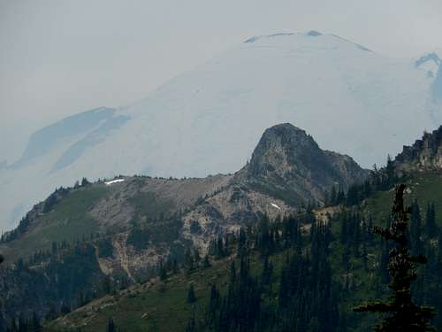
Slide Mountain from the summit of South Slide Mountain. From this point, one can see the difficult terrain that must be negotiated. Stay on the left (west) side of the ridge, down climbing talus and scree to get to the gentle western slopes of Slide Mountain. July 31, 2013.
When to Climb
The prime determinant of when to climb is access to the road to Sunrise. Usually, this road and the visitor center are open in the late spring. Consequently, prime climbing season here would be June through October. In the fall, this area is frequented by large number of elk, which can be heard bugling during the rutting season. Climbing season would end with the first major snowfalls, usually after mid-October.External Links
For information including road closures and camping restrictions, you can contact Mount Rainier National Park at: Mt. Rainier National ParkAnother great site is this excellent Mt. Rainier climbing blog, which gives up-to-date snowpack and road conditions on Mt. Rainier and the all of the roads: Mt. Rainier Climbing Page