
-
 9506 Hits
-
 78.09% Score
-
 9 Votes
|
|
Mountain/Rock |
|---|---|
|
|
47.99491°N / 121.17212°W |
|
|
Hiking |
|
|
Spring, Summer, Fall |
|
|
6721 ft / 2049 m |
|
|
Overview
This significant summit, with 1,241 feet of prominence, is neatly tucked in between several boundaries and forms the headwaters of Sloan Creek. The mountain is relatively moderately sloped with most angles under 35 degrees. The final 1,000' is open meadows on the South and easy class 2 rock on the North with evidence of past glaciation and a few permanent snowfields. There is a trail that snakes its way to the summit from a junction with Pilot Ridge. The view from atop is a fantastic triple volcano stunner in fair weather and makes a great finish to anyone either staying at the Blue Lakes or traversing the Pilot Ridge Trail.A benchmark on the summit notes placement in 1945. On the Western highpoint a flat area with four bent rods, cable, pieces of wood and scattered, weathered glass shards denotes an old lookout. Pilot Ridge shoots off of the western flank of the mountain while Big Blue Lake sits 0.6 miles away at its Southern base.
Several important trails join around the mountain: Pilot Ridge wraps around it's upper western slopes to Little Blue Lake and junctions with a pack trail that meets Big Blue Lake and the PCT to the East; Pilot Ridge continues past Little Blue Lake to connect with Bald Eagle Trail 1.6 miles to the South. The summit lies within the boundary of Glacier Peak Wilderness.
 Big Blue Lake and blue ridges from Johnson | 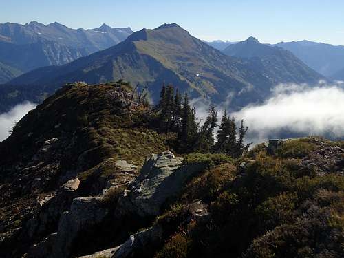 Indian Head from Johnson. |
Getting There
Via North Fork Sauk:
From Darrington - head south on the Mountain Loop Highway 16 miles until you reach North Fork Sauk River and Take a Left following North Fork Sauk NF 49 until North Fork Sauk trailhead.From Granite Falls - head East on the Mountain Loop Highway 37.3 miles (over and past Barlow Pass) until you reach North Fork Sauk NF 49 and Take a right. Rest is the Same as from Darrington
Via US Highway 2:
From the West take US Highway 2 to Skykomish. Continue on US 2 watching on the left for Beckler River Road at about milepost 49. From the East, take US 2 over Stevens Pass to Beckler River Road just 1/4 mile past Skykomish Ranger Station on the right. Continue up Beckler River Road 12.5 miles to Jack pass at a 4-way intersection. Continue strait for 2.3 miles to a 3-way intersection and turn right onto NF- 63 towards Blanca Lake. At milepost 17, Blanca Lake is on the left: veer right continuing to the North Fork Skykomish Trailhead. Depending on your route there are a few options on trails.

Looking at Goblin and Kyes shrouded in clouds from a field of daisies. Taken on the way down from Johnson approaching Curry Gap 9-8-2013.
Route
| Trail/Route | Distance round-trip (miles) | Starting Elevation (feet) | Description |
| North Fork Sauk 649/ Pilot Ridge Trail 652 | 20 | 2450 | Follow North Fork Sauk for about 1.8 miles to the junction with Pilot Ridge Trail. Take a right onto the Pilot Ridge Trail, crossing the Sauk River (which may be difficult early season) and gaining 3,000' to the ridge through old growth forest. The trail stays mostly on Johnson's NW ridge crest breaking in and out of alpine meadows once above 5,000'. The junction for Johnson Mountain will be fairly obvious on the left at about 6,000'. |
| Quartz Creek 1050/ Bald Eagle Trail 650/ Little Blue Lake to Pilot Ridge | 30.5 | 2500 | Follow Quartz Creek trail just over 4 miles to Curry Gap Junction (open meadows) then take a right to Bald Eagle Trail. Follow the trail which will crest a ridge below Bald Eagle and continue bumping up and down across alpine meadows and interspersed forests, passing June Mountain, until a 3-way junction with Bald Eagle (the one you're on), Pilot Ridge and a PCT connection trail. Take Pilot Ridge down an open drainage to Little Blue Lake and then up heathery slopes to the final junction with Johnson Mountain at about 6,000'. |
| North Fork Skykomish River 1051/ Dishpan Gap | ~28 | 2500 | Take North Fork Skykomish up a long ways up the valley to a 4-way junction at Dishpan Gap. Take the left trail that heads towards Bald Eagle Trail and Pilot Ridge. At the 3-way Bald Eagle/Pilot Ridge/PCT junction take a right onto Pilot Ridge Trail. Follow it down to Little Blue Lake and up open heather slopes to 6,000' where a junction with Johnson Mountain is on the right. |
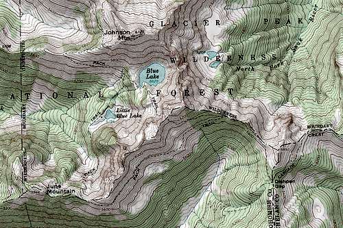
Map of Johnson Mountain. Many trails junction around it.
What to Bring
Ice-ax and crampons in early season. Rain gear for wet weather or when meadows are dewy as trails can be overgrown since they are generally not maintained. In late season water sources are limited to the Blue Lakes and only a select few streams with several miles inbetween. Fill up when you can.
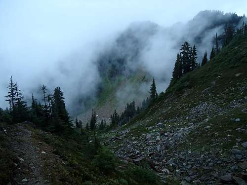
Taken on 8-31-2013 by Cyohma on the way to Little Blue Lake. It rained all day that day which seemed unusual to me for the time of year.
Red Tape
A Northwest Forest Pass is required to park at either trailhead. Keep the management happy...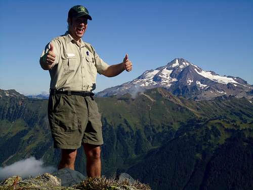
by following the rules
When to Climb
Spring through Autumn. Winter ascents are possible but access may be limited if either Jack Pass or North Fork Sauk Road are closed. Visit Northwest Avalanche Center for snow conditions in early season.Camping
Camp only in designated camping sites.Resources
Current Conditions:Call Darrington Ranger District at: (360) 436-1155
Call Skykomish Ranger District at: (360) 677-2414
Weather:
Johnson Mountain/Stevens Pass Forecast on Weather.gov
Road Conditions:
US Higway 2 access
Mountain Loop Highway access