Overview
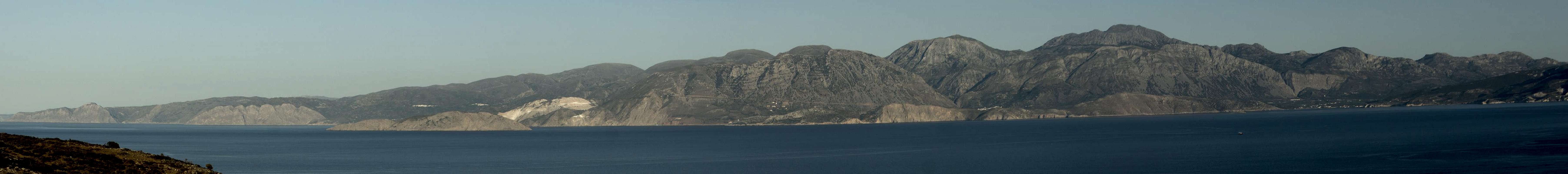
![Afentis Stavromenos]() Afentis Stavromenos seen from the north-east
Afentis Stavromenos seen from the north-east
Of the dozen mountain ranges on the island of
Crete / Κρητι only three surmount 2000m.Still, even the lower ranges remain impressive, especially if they rise out of the sea for more than 1000m still. One of these ranges is
Orno Thriptis / Ορνο Θριπτης, located to the east of Crete's isthmus in the eastern third of the island. At more than 1400m height it rises directly out of the
Lybian Sea while the northern coast (and with it the Cretan sea is readily visible across its neighbour range Orno
Oros / Ορνο Ορος. The range is named after the village
Thripti / Θριπτη right in its centre.
At 1476m
Afentis Stavromenos / Αφέντης Σταυρομενοσ is the highest mountain of
Orno Thriptis. It is considered the best lookout in the east of
Crete and on a fine day you can readily see why. While the eastern peninsula of the island lies directly at your feet the Mirabello Gulf is not far away and on the western horizon you will see the
Dikti Range, Crete's third highest mountain region.
Orno Oros and Orno Thriptis seen across Mirabello Gulf |
Being a lookout, however, also has its drawbacks.
Afentis Stavromenos serves the area beyond the isthmus with radio and TV installations which mar the summit experience. Also, for maintenance purposes a dirt road leads to the summit so that access is comparatively easy. For hikers which prefer scrambles to comfortable road access, there is a route from
Thripti through the brittle north face of the mountain, an impressive hike, though a bit hazardous due to possible rockfall.
Afentis Stavromenos, as the culmination point of
Orno Thriptis and the whole eastern peninsula can be seen from almost any part of eastern Crete. It is made up from brittle imestone, which tends to form Karst formations. The range,
Orno Thriptis is well known for its canyons, which cut deep into the sides of the range as well as its caves underneath the plateau-like surface. Unlike the canyons of western
Crete, the eastern ones are very steep running from elevations of about 1000m to the sea level in only a few kilometres.
Ha Canyon is the most famous of these canyons, it runs from Thripti westwards down to the plain of the Isthmus. It also is one of the best known canyoneering destinations of
Crete.
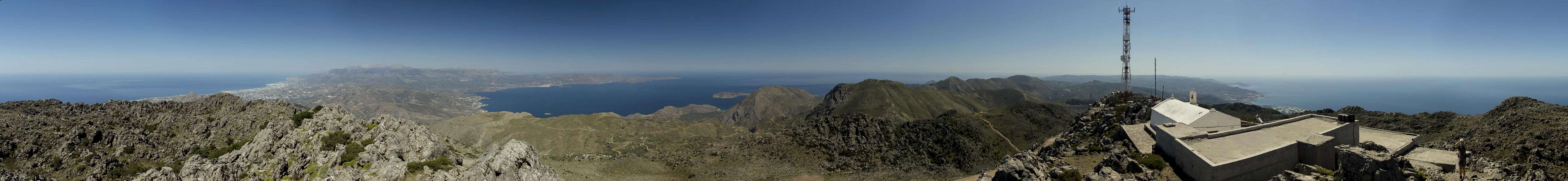
360° Summit Panorama
360° summit panorama from Afentis Stavromenos |
Getting There
![Orni Oros]() Northward view from Afentis Stavromenos towards Orno Oros
Northward view from Afentis Stavromenos towards Orno Oros
There are two international airports on Crete, both in the north of the island. One is at
Chania in the west, the other is at
Heraklion in the centre.
There are myriads of ferries in Greece, which connect the many islands of the country. Consequently there are many ferry harbours and Crete is no exception. However, most of the smaller harbours only cater for transportation to the other islands while the major lines to the mainland are reserved to two harbours,
Souda near
Chania and
Heraklion. Both serve connections to
Peiraias and
Thessaloniki.
To reach the trailhead
- take highway 90 (E75)east through Agios Nikolaos and on to Pachia Ammos.
- Here turn southward in direction of Ierapetra.
- At Kato Chorio switch to the very narrow mountain road to Thipti.
Routes
![Hiking through the Afentis Stavromenos North Face]() Hiking through the Afentis Stavromenos North Face
Hiking through the Afentis Stavromenos North Face
There are two routes to the summit.
- The regular route follows the maintenance road for the radio station on top of Afentis Stavromenos. It is roundaboutish and offers little shade. Still, the route remains impressive as the road runs through the very steep north-east face of the mountain.
- The direct hike / scramble through the north face of Afentis Stavromenos is the far better alternative. You hike to the uppermost part of Thripti Village, from where a path heads into the north face. Take care as this is rockfall area and the rock is very brittle. The path tops out on a plateau from which the uppermost part of maintenance road can be reached.
.
Red Tape
There's no red tape. The radio installation on the summit is off limits, however.
Accommodation
![Thripti]() The trailhead at Thripti Village beneath the Dikti Range
The trailhead at Thripti Village beneath the Dikti Range
You can quite easily find hotel rooms and apartments everywhere on the coasts. All European travel companies offer accommodation so a visit to your nearest travel office will find you some. In the mountain villages there always are inns and if everything fails you can pitch a tent.
There are abundant campgrounds along the coast and on many of the beaches you can pitch your tent. The touristic beaches in the north and the beaches in the vicinity of tourist towns are mostly off-limits but there is many a cove which you can use. In the mountains you will often find cattle (goat and sheep) fences which you should respect.
Weather Conditions
Maps & Books
There are quite a number of maps and books out there, which deal with the island of Crete and naturally I don’t know them all. This is the list of maps and books which I used and I appreciate it very much if you can add to it
Maps
Unfortunately there are no decent topographic maps of Crete. The best maps I could find are scaled 1:100000 and contain the main hiking routes on the island. In one case the map showed wrong paths and roads (exchanged them) but in general they were quite useful. In any case they were better than the Anvasi Maps, also scaled 1:100000, which claim to be topographic maps but miss routes and even mountains
- Kreta / Crete / ΚΡΗΤΗ Western Part
Touring Map
1:100000
Harms Verlag
ISBN: 3-927468-16-9
- Kreta / Crete / ΚΡΗΤΗ Eastern Part
Touring Map
1:100000
Harms Verlag
ISBN: 3-927468-17-7
Books
Since there are no good topographical maps of Crete you should take care to get a good guidebook. The ones I used have good tour suggestions though the descriptions often are somewhat shortish and can be misleading. The books are available in German and English.
- Kreta Ost / Crete East
Gert Hirner / Jakob Murböck (translation: Gill Round)
Rother Verlag
ISBN:
978-3-7633-4004-0 (German)
978-3-7633-4822-0 (English)

 6331 Hits
 74.92% Score
 5 Votes
 Afentis Stavromenos seen from the north-east


 Northward view from Afentis Stavromenos towards Orno Oros
 Hiking through the Afentis Stavromenos North Face
 The trailhead at Thripti Village beneath the Dikti Range