Comments
No comments posted yet.
On Wednesday, August 5, Randy Hickman and I made the 100
mile drive from Blackfoot to the mouth of Pete Creek in the Lost River Range of
Idaho. Our goal was a Thursday summit attempt of Mt. Breitenbach – Idaho’s 5th
highest mountain at an elevation of 12,140 feet. All of our research indicated
that the best route reach the trailhead was to drive take the Upper Cedar Creek
road east and then traverse along the alluvial fan to the north until reaching
the mouth of the canyon. About a mile up the road we had to open a gate to
continue on. A pick up pulled up behind us and the driver quizzed us about why
we were up in this area. After telling him we were going to climb Mt.
Breitenbach, he indicated that a better way to reach the mouth of Pete Creek
Canyon was to return to the main highway, travel north two more miles, and then
turn east and head straight up to the canyon. Using our instincts and common
sense, we were able to navigate our way to the mouth of the canyon but ended up
on the north side of the drainage. We would have been better off going the way we
had intended as that route would have kept us on the south side of Pete Creek
and allowed us to park the pickup further up the canyon.
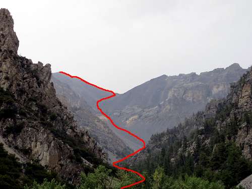
Once at the end of the road, we hiked up Pete Creek a
quarter mile so as to become familiar with the route up the first part of the
canyon. As soon we started exploring, we began to find a lot of fossils in the
rocks. This would continue through the next day all the way to the top of the
mountain. It was very easy to find fossils of horn corals, colonial corals,
crinoids, brachiopods, and gastropods (snails). We found more fossils on this
mountain top to bottom than on any other mountain we have been on. In fact
during our hike to the top the next day, I would find and pack out the largest
horn coral fossil that I have ever seen before. While not complete, it is a
very impressive specimen with a diameter of 3.5 inches. That night we slept in
the cab of Randy’s pickup and the stars in the sky were spectacular. I have
never seen so many at any given time and it was also possible to pick out the
haze of the Milky Way across the night time sky.
Thursday morning, the alarm sounded at 5:30 and we were on
the trail shortly after 6:00. The hike up Pete Creek was a pleasant surprise as
we were expecting to bushwhack our way up the canyon but instead found we only
had to pick our way either along or up the dry creek bed. There were plenty of
stinging nettles but for the most part they were easy to navigate around. Pete
Creek remained dry for the first three-quarters of the way up the valley and
then the creek flowed with plenty of water until we reached the upper end of
the drainage. The rocks were solid and we made steady progress until we reached
the endless slope of scree leading up to headwall of the cirque and then on up
to saddle between Mr. Breitenbach and Lost River Peak. Time passed quickly as
we were always on the lookout for fossils and frequently stopped pondering
whether or not to keep our new find. If the specimen was too big to pack to the
top, we would put it next to a rock cairn in hopes that we would find it on the
way down. We did this five times and found three of our five stashes as we
hiked out. There were several small waterfalls along the way as water poured
out over a cliff face. Just past the upper waterfall we turned right and
climbed up an easy cliff before continuing east toward the saddle. We were once
again we were pleased that the rock all along the scree slope was stable and we
could steadily hike upward without sliding backwards on each step.
As we approached the saddle, the wind began to kick up and
once on the saddle, the wind increased in velocity easily blowing 30 mph plus.
It was blowing so hard it forced us to seek shelter behind rock outcrop as we
took a rest and snack break before making the final push up the ridgeline to
the summit. Between the saddle and summit, there were two false summits which
we had to pass up and over. As we worked our way along the ridge, the wind
punished us with sustained winds at over 30 mph gusting at times to 50 mph. It
was a pretty unnerving at times as the trail moved very close to the edge of
the ridge where the east side plunges 100’s of feet to the valley floor or
narrowed to a knife shaped section of 75 yards or so. We had to be extra
vigilant with our footing and balance as the intense wind made several pretty
good attempts at blowing us off the ridge into the oblivion below. The wind
also created a pretty good wind chill and both us were feeling the effect of
the cold. Due to the extreme weather conditions, we were both expecting a very
short stay on the summit. Once again, the rock was solid all along the ridge
trail and we made our way up and over the two false summits to the top of
Breitenbach much quicker than expected. We stepped onto the top of Breitenbach
at 11:30 and would have easily made it by 11:00 had we not spent so much time
hunting for fossils on the way up. There were some great fossils of horn corals
close to the summit but they were way too big and heavy to pack out. The wind
on the summit was bad but not as bad as along the other parts of the ridgeline.
We ended up spending 30 minutes on the summit taking pictures and signing the
summit register. The view from the top was impressive. To the north we could
see Donaldson Peak, Mt. Church, Leatherman Peak, Mt. Idaho, and Borah Peak –
all 12,000 foot peaks that we have both previously summited.
We weren’t looking forward to battling the wind back down
the ridge and decided that we would save our lunch until we got off the ridge
and down to a point where the wind was less intense. We left the summit right
at noon and after 90 minutes of hiking down we stopped, took a break, and ate
some lunch. We didn’t have cell service on the summit but did down in the
cirque and so called our wives letting them know that we had made to the top
and were well on our way back down. The hike down was not near as much fun as
going up as the solid rock that made it easy going up, pounded our feet,
ankles, and knees all the way from the summit to the trailhead. The going was
very slow and methodical as we had to watch each step and make sure we didn’t
twist a knee or ankle. Soon we stopped searching for fossils and all that
mattered was getting back to the pickup. The trek down Pete Creek seemed like
it would never end and the sun was now baking us. Finally after 10.5 hours of
hiking, our hike ended at 4:30 P.M when we arrived back at the trailhead. Our
bodies were shot from the waist down but we were riding high as our hike to the
top of Mt. Breitenbach marked our eighth successful summit out of Idaho’s nine
12,000 foot peaks. The only mountain left between us and our bucket list quest
is Lost River Peak which we hope to knock off in 2016.
Note that from our perspective the hike to the top of
Breitenbach is a low end class 3 (maybe even a class 2) and is much easier
going up than down.
Click on the link below for more pictures.