
-
 12759 Hits
-
 78.27% Score
-
 9 Votes
|
|
Route |
|---|---|
|
|
39.29589°S / 174.06409°E |
|
|
Hiking, Mountaineering |
|
|
Most of a day |
|
|
Class 2 |
|
|
Overview
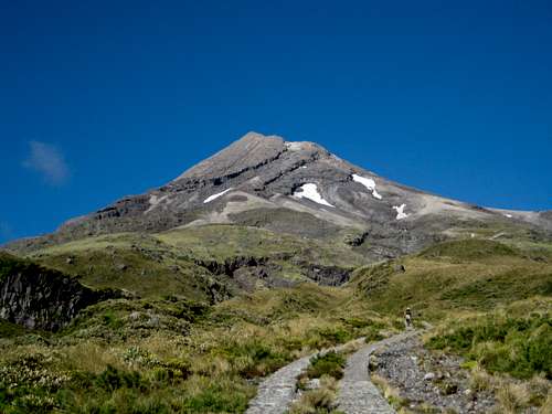 Mt Egmont/Taranaki north face Mt Egmont/Taranaki north face |
Beyond the hut the route enters the Hongis Valley up which DoC have built wooden stairs to almost 1,800 metres to counter erosion.
Once clear of the valley open scoria slopes lead west to the “Lizard” ridge at about 2,000 metres. From the top of the ridge the summit lies about 10 minutes away across the snow filled crater followed by a final loose scramble.
Getting There
Approach the North Egmont Visitor Centre, the starting point for the north side route on Egmont/Taranaki from Hawera in the south or from New Plymouth to the north.From Hawera at the junction of SH 45 and SH3 drive 19 km north on Route 3 to Eltham. Continue north on SH 3 beyond Eltham for 11 km to Stratford. Continue beyond to Stratford on SH 3 for 23 km to Inglewood and then a further 5.5 km to Egmont Village. Egmont Road is well signed in the village. Turn left and follow the road south for 16 km to the North Egmont Visitor Centre from where the North Route starts.
Or approach from New Plymouth by driving 13 km south on SH 3 to Egmont Village, turn right and join the approach just described.
Route Description
Starting from the North Egmont Visitor Centre at about 890 metres elevation, walk through the gate and up the “Translator Road” used to access the communications facility on the ridgeline ahead. You will soon see the aerials after the first couple of switchbacks in the road.It’s about 1-1.5 hours of steady climbing up to the comm. station and on up to the private Tahurangi Lodge at S39 17.353 E174 04.958 and about 1,500 metres. This make a good place for a stop with toilets nearby and benches at the hut that the public may use.
Beyond the hut the track enters the Hongis Valley where DoC has installed a lot of anti-erosion measures: back-filled stone steps and even wooden staircases higher up as the track emerges onto open scoria slopes.
 Open slopes below the Lizard Open slopes below the Lizard |  Approaching the Lizard Approaching the Lizard |  The Lizard ridge The Lizard ridge |
Beyond the staircases the poled track heads almost due west on typically loose volcanic terrain as it heads for the rocky ridge crest of “The Lizard” ahead.
Once on the Lizard the route swings gradually south and although still loose in places, firm going can be found for those who don’t mind a bit of low level scrambling.
 North crater entrance North crater entrance |  Mt Egmont/Taranaki summit crater Mt Egmont/Taranaki summit crater |  Mt Egmont/Taranaki true summit Mt Egmont/Taranaki true summit |
The usually snow filled summit crater is finally reached at about S39 17.666 E174 03.897 and the true summit is then a brief 10 minute walk south across the snow in the crater and west up a final scoria slope.
Return to the trailhead by reversing the above.
Route summary:
Distance: ~ 12.5 km
Net elevation gain: ~ 1,630 metres
Total elevation gain: ~ 1,650 metres
Approximate times: ~ 4-5 hours up, 3-3.5 hours down, 1 hour for breaks.
As always a Garmin/Mapsource tracklog is available for the route described. As a general rule I don't make routes universally available as GPX files but just ask for it via an email or PM
Essential Gear
Nothing out of the ordinary in the way of gear but be aware that rapid weather changes are the order of the day on Egmont, so be ready for anything.Take warm clothes and lots of water at any time of the year and an ice axe for use in winter conditions.