
-
 23198 Hits
-
 78.27% Score
-
 9 Votes
|
|
Mountain/Rock |
|---|---|
|
|
13.96418°N / 121.24138°E |
|
|
Mountaineering |
|
|
Spring, Fall, Winter |
|
|
3297 ft / 1005 m |
|
|
Topographic isolation: 21 km
Nearest higher peak: Mt. Makiling 1144 m
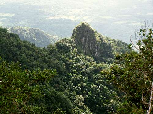
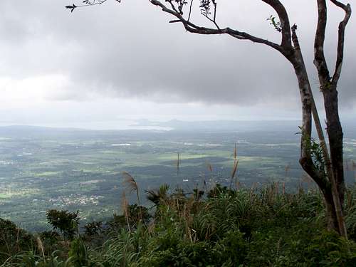
Prominence: 800 m![View from the summit - Mt. Malipunyo]()
A nice volcanic rock
Mt. Malipunyo has other names and variation of names, too: Mt. Malepunya, Mt. Malipuño and Mt. Malarayat.
The mountain is in the Batangas and in the Quezon Province of Luzon Island, approximately 70 km south of Manila. The mountain is 15 km long volcanic range, stretching in north-south direction. It is the main attraction of the southern Tagalog landscape. This mountain is densely covered with intact tropical forest.
Mt. Malipunyo has three peaks with approximately equal elevation. The summit – Peak 3 – is 1005 meter ASL. The other major peaks are Susong Dalaga and Manabu Peak.
I hiked/climbed 6 mountains in the Philippines. It was the only one that I visited twice. This was the place that gave me the most impressions
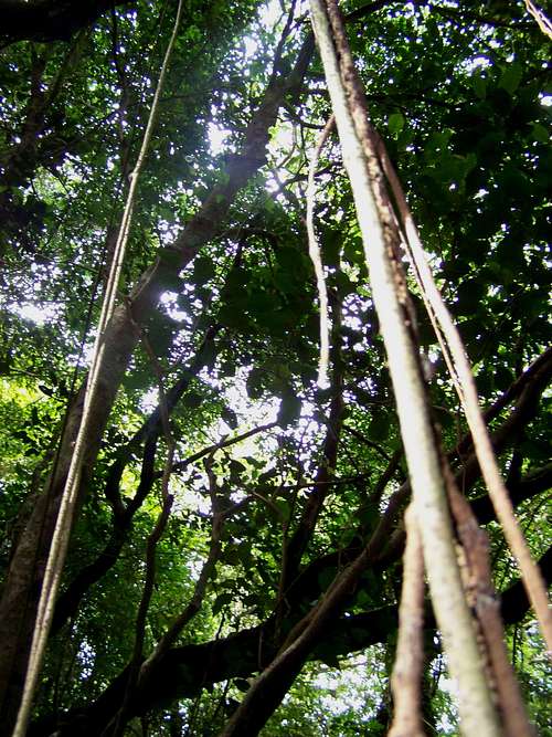
![The jungle - Mt. Malipunyo]()
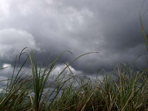
JUNGLE![The grassland of Mt. Malipunyo]()
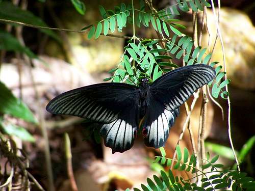
This elephant grass is 2 m high![Once in a life (Papilio memnon - local subspecies on Malipunyo)]()
Papilio memnon![Flora on Mt. Malipunyo]()
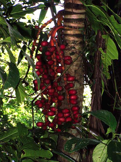
Blue berries
See some photos are inserted here. And others as attachments.
Animals such as wild boar, monkey and iguana are also claimed by the locals to be present on the mountain. And in the forest there are snails of 10 cm diameter near the summit.![Goat kid. 1 hour old]()
New born goat kid![Flora on Mt. Malipunyo]()
Red flowers![Flora on Mt. Malipunyo]()
Lilac flowers![A kind of palm tree]()
A kind of palm tree![Butterfly (Danaus choaspes) on Mt. Malipunyo]()
Danaus choaspes
![Navigation in Lipa City]()
From Lipa City to Talisay
Take an early morning bus around 5 a.m. from Manila to Batangas City. They depart very frequently (at least every 30 minutes) from the Pasay Bus Terminal. After 2 hours of travelling get off the bus at the highway exit of Lipa City. Immediately at the bus “unloading” point you can get on a jeepney taking you to the center of Lipa City. Get off at the Robinson’s shopping mall. There is a McDonald’s, too, appropriate for breakfast. Take there another jeepney, going further on the diagonal road to north-east. Get of the jeepney at the sideroad leading to east, to Village Talisay. But locals may know better that the road leads to the Golf and Country Club. Take there a tricycle or a jeepney to the village to Talisay.![Mt. Malipunyo overview map]()
From Talisay to PeaK 3
Follow the attached itinerary to find the trailhead of the 4 x 4 roed going out of Talisay in eastern direction. After an easy 2.5 km you will reach the last houses in the valley. The 4 x 4 road ends here and the muddy trail going up the valley starts here. After 1 km you will find a considerable trail going down to the stream to right hand side. Don’t go there. A few hundred meters later another trail goes down to the stream to right hand side. The main trail goes ahead upwards the hill. But you take the one going right. Cross the stream. Finding the right trail here is not the easiest thing.
After a while you will see a side trail to the left up to the hill. Or you will not see it. If you don’t see it, then soon you arrive to a place where there are some minor traces of human activity, plus a water source. Turn back and try to find the trail going upward the hillside. When you found it, go up the hill a few dozens of meters, and find another trail going to right, in the side of the hill. Bonus for you if you can do it!
A half hour later you can get out of the forest reaching the grassland called “Talahiban” where the trail of this described itinerary is crossed by another trail used for crossing the mountain from the west side to the east side. For this crossing trail this is the pass when crossing the mountain. But you go ahead into the rarely used train into the dense forest, up the hill. Take high attention where you go. Not easy to follow the trail, and what is even more important – you will have to find the way back, too. And that time it may be already late afternoon with limited visibility in the forest! After a 40 minutes climbing on the very steep hillside you will join into a trail. Turn left here. This trail will quickly lead you up to the ridge of the mountain, to 900 meter elevation. Turn here left, too, and continue your way on the ridge. From here you can’t be lost any more. But the trail is not less of dangers: it’s going on a sharp edge, with big depth on the left side. A 800 meter walk on this edge and you are on the peak.
![The South China Sea - as seen from Mt. Malipunyo]()
South China See - as seen from the summit![On the summit of Mt. Malipunyo]()
Summit Cross
http://www.pinoymountaineer.com/2007/10/mtmalipunyomalarayat.html
Nearest higher peak: Mt. Makiling 1144 m
Prominence: 800 m
Overview
A nice volcanic rock
Mt. Malipunyo has other names and variation of names, too: Mt. Malepunya, Mt. Malipuño and Mt. Malarayat.
The mountain is in the Batangas and in the Quezon Province of Luzon Island, approximately 70 km south of Manila. The mountain is 15 km long volcanic range, stretching in north-south direction. It is the main attraction of the southern Tagalog landscape. This mountain is densely covered with intact tropical forest.
Mt. Malipunyo has three peaks with approximately equal elevation. The summit – Peak 3 – is 1005 meter ASL. The other major peaks are Susong Dalaga and Manabu Peak.
I hiked/climbed 6 mountains in the Philippines. It was the only one that I visited twice. This was the place that gave me the most impressions
Why Not to Go?
JUNGLE
- Most of the mountaineers get lost here. The last group reported in the news as lost before the creation of this site description was on the 28th May 2009. The group finally luckily arrived to San Pablo City
- If you ask locals about the whereabouts, they don’t necessarily give you correct answers (because they don’t know it well)
- Noxious plants, including the pruritogenic (itch-causing) lipa trees are present in this mountain; it is best to take this in consideration in clothing selection
- Thorns-bushes – one thorn ended in my ear, making it blooding. I protected my hands with Kevlar-gloves normally used for via ferrata.
- Long sections of the trail is very muddy, specifically when crossing the stream. You can “walk” in 10 cm deep mud during kilometres.
- Trail sections on very steep hillsides. Very slippery in the rainy-season
- Rarely visited place. In case of any accident – if you are alone – you cannot expect help during days
- Near 100% air humidity. In most times the hill is in clouds
- Rumoured activity of anti-government rebels in the mountain
Why to Go?
This elephant grass is 2 m high
- You can get an experience that is not given to most people
- See the Flora and Fauna paragraph below
Flora and Fauna
Papilio memnon
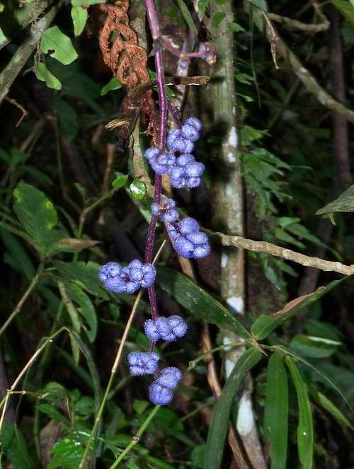
Blue berries
See some photos are inserted here. And others as attachments.
Animals such as wild boar, monkey and iguana are also claimed by the locals to be present on the mountain. And in the forest there are snails of 10 cm diameter near the summit.
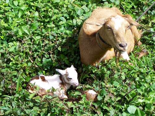
New born goat kid
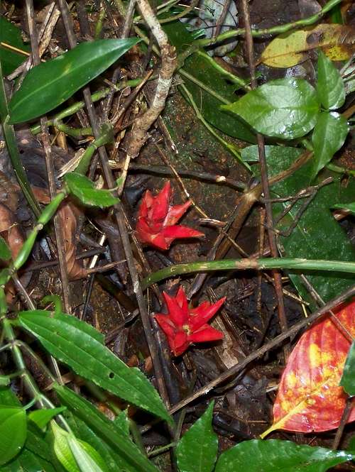
Red flowers
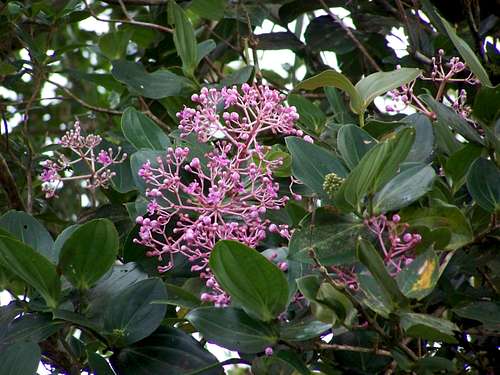
Lilac flowers
A kind of palm tree
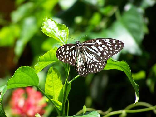
Danaus choaspes
How to Get There
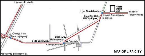
From Lipa City to Talisay
Take an early morning bus around 5 a.m. from Manila to Batangas City. They depart very frequently (at least every 30 minutes) from the Pasay Bus Terminal. After 2 hours of travelling get off the bus at the highway exit of Lipa City. Immediately at the bus “unloading” point you can get on a jeepney taking you to the center of Lipa City. Get off at the Robinson’s shopping mall. There is a McDonald’s, too, appropriate for breakfast. Take there another jeepney, going further on the diagonal road to north-east. Get of the jeepney at the sideroad leading to east, to Village Talisay. But locals may know better that the road leads to the Golf and Country Club. Take there a tricycle or a jeepney to the village to Talisay.
The Way up to the Peak
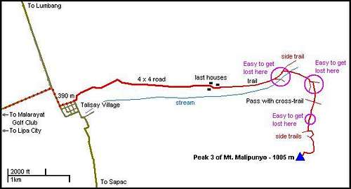
From Talisay to PeaK 3
Follow the attached itinerary to find the trailhead of the 4 x 4 roed going out of Talisay in eastern direction. After an easy 2.5 km you will reach the last houses in the valley. The 4 x 4 road ends here and the muddy trail going up the valley starts here. After 1 km you will find a considerable trail going down to the stream to right hand side. Don’t go there. A few hundred meters later another trail goes down to the stream to right hand side. The main trail goes ahead upwards the hill. But you take the one going right. Cross the stream. Finding the right trail here is not the easiest thing.
After a while you will see a side trail to the left up to the hill. Or you will not see it. If you don’t see it, then soon you arrive to a place where there are some minor traces of human activity, plus a water source. Turn back and try to find the trail going upward the hillside. When you found it, go up the hill a few dozens of meters, and find another trail going to right, in the side of the hill. Bonus for you if you can do it!
A half hour later you can get out of the forest reaching the grassland called “Talahiban” where the trail of this described itinerary is crossed by another trail used for crossing the mountain from the west side to the east side. For this crossing trail this is the pass when crossing the mountain. But you go ahead into the rarely used train into the dense forest, up the hill. Take high attention where you go. Not easy to follow the trail, and what is even more important – you will have to find the way back, too. And that time it may be already late afternoon with limited visibility in the forest! After a 40 minutes climbing on the very steep hillside you will join into a trail. Turn left here. This trail will quickly lead you up to the ridge of the mountain, to 900 meter elevation. Turn here left, too, and continue your way on the ridge. From here you can’t be lost any more. But the trail is not less of dangers: it’s going on a sharp edge, with big depth on the left side. A 800 meter walk on this edge and you are on the peak.
On the peak
South China See - as seen from the summit
In April 2008 the peak has been cleared from vegetation. Now the peak can serve as a viewdeck. A plaster statue of crucifix has also been erected. From the peak you can look around almost in 360°. You can see the South China See, Mt. Maculot, the Taal Lake, San Pablo City, the Banahaw-complex, and many other things. The two other major peaks of the mountain - Susong Dalaga and Manabu Peak – can be also seen from here.
The peak is an appropriate place for a few tents – but of course without any facilities. You must expect a cool and occasionally a windy night if you spend it there.
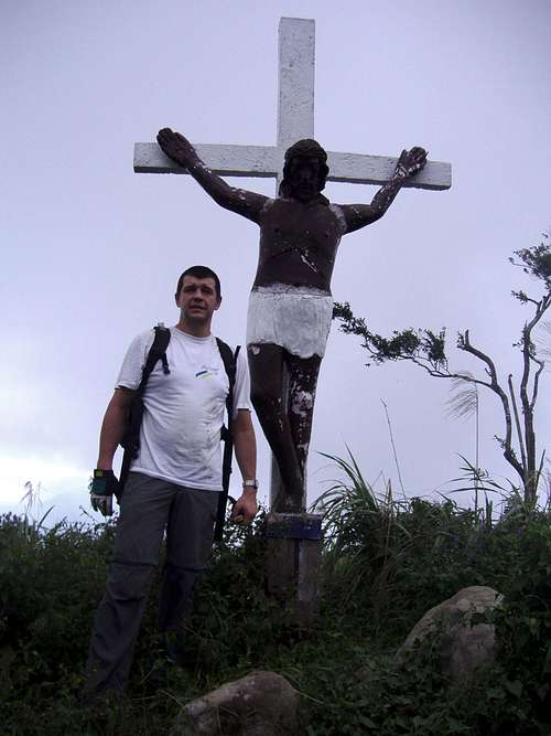
Summit Cross
Links
Pinoy Mountaineering site:http://www.pinoymountaineer.com/2007/10/mtmalipunyomalarayat.html