
-
 4120 Hits
-
 75.81% Score
-
 6 Votes
|
|
Route |
|---|---|
|
|
46.80182°N / 11.39593°E |
|
|
Hiking, Scrambling, Via Ferrata |
|
|
Summer, Fall |
|
|
Half a day |
|
|
Easy Ferrata |
|
|
Overview
|
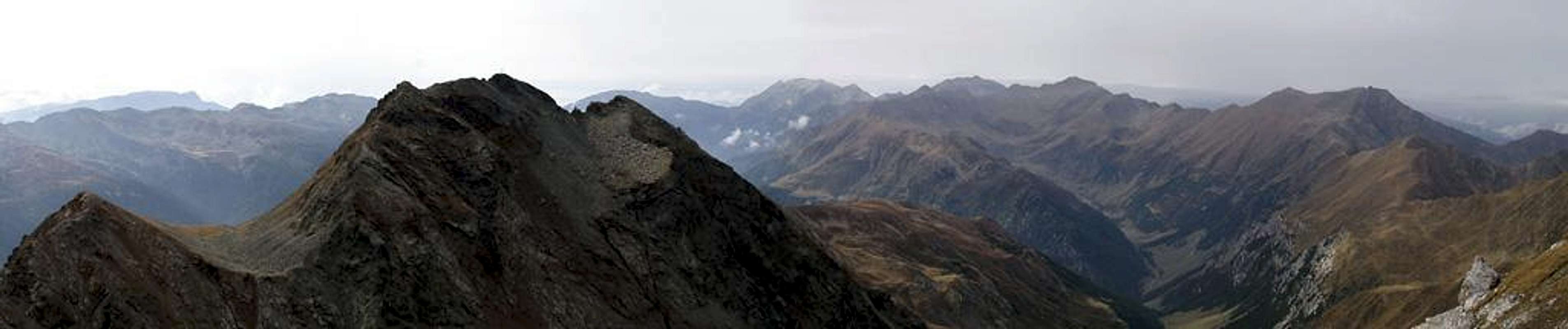

Sarner Weißhorn / Corno Bianco Sarentino has an astonishingly easy normal route - given the fact that it looks like the participant of a Matterhorn lookalike contest when seen from Penser Joch / Passo di Pennes. The first part of the climb is just a hike to the col between Weißhorn and neighbouring Gröllerspitze (2590m, Italian name unknown) from where a short but steep ferrata starts which scales the last 150m of elevation.
Due to the proximity to Penser Joch / Passo di Pennes the climb is supposed to be very popular. However we encountered only a handful of fellow climbers - and when we were already returning to base. September seems to be a good month here, though certainly the weather was to blame for the lack of interest in our fellow climbers.
Getting There
 On the summit of Sarner Weißhorn / Corno Bianco Sarentino
On the main page you can find how to get to Penser Joch /Passo di Pennes. From there a marked trail leads directly to the col between Weißhorn and Gröllerspitze. However, there is a second (virtually unmarked) well trodden path, leading across Ganskragenspitze / Punta di Campo (2322m) and Röthenspitze / Punta Rossa (2441m) into the south face of Weißhorn. Depending on the weather - and whether you have enough time - rather follow this scenic path which gives you the far better views and takes but 30 - 45 minutes longer. Often this route is chosen to return to Penser Joch / Passo di Pennes).
Route Description
 Steep section on the ferrata just beneath the summit
- Start altitude: 2211m (Penser Joch / Passo di Pennes)
- Summit altitude: 2705m
- Prevailing exposure: S
- Type: 2h over paths (2 1/2 h over the additional summits), 30 min on a ferrata
- Protection: Protected by about 80m of strong fixed cables
Directly on Penser Joch / Passo di Pennes you will find a sign leading towards Weißhorn / Corno Bianco. The trail is marked 12a and can't be lost. A second path leads directly up Ganskragenspitze / Cima di Campo, which overlooks the pass on its north-western side. Once on the summit you will be able to see footpaths which eventually lead to Röthenspitze and from there into a little forcella between Röthenspitze and Weißhorn. Don't search for signs - there are some but they are scarce.
Once in the col between Röthenspitze and Weißhorn, both paths recombine to climb underneath the Weißhorn south face to a clearly visible col south of the summit, but north of Gröllerspitze and Mudatsch / Mudaccio. Here - after a few steps - the ferrata starts.
The first secured stretch leads into the wall along a loosely fixed 20m long cable. Meant not as a protection this cable can be used to draw oneself upwards. From the end of this cable the climbing gets far steeper and now a fixed 10m section helps you up. From the top of this section turn left and head (unprotectedly) to a shoulder in the south-west of the summit (nice views down onto Mudatsch / Mudaccio) where the final ascent turns directly towards the summit and is protected by two 10m stretches of fixed cables. The summit ridge is astonishingly broad, some 30 - 40m.