
-
 8851 Hits
-
 85.39% Score
-
 21 Votes
|
|
Route |
|---|---|
|
|
45.09921°N / 109.63314°W |
|
|
Hiking, Mountaineering, Scrambling, Skiing |
|
|
Spring, Summer, Fall, Winter |
|
|
Most of a day |
|
|
40 degree snow |
|
|
II |
|
|
Overview
Castle Mountain stands as the forth highest peak in all of Montana and sits at the apex of the mighty Beartooth Mountains. To the north the mountain drains into the East Fork Rosebud Creek drainage, to the east it drains into the West Fork of Rock Creek and to the south water drains into the Clark Fork of the Yellowstone River down the Beartooth Plateau. On the northeast aspect of the mountain lies the mighty NE couloir which ascends straight up to the summit plateau over a vertical distance of 1,200 feet. This is a very popular backcountry ski descent and makes a fantastic snow climb that isn't too crazy. This climb is recommended for those who seek a slightly greater challenge than the standard south slopes route from Omega Pass but may not be quite ready to tackle the Whitetail Couloir just across the valley.
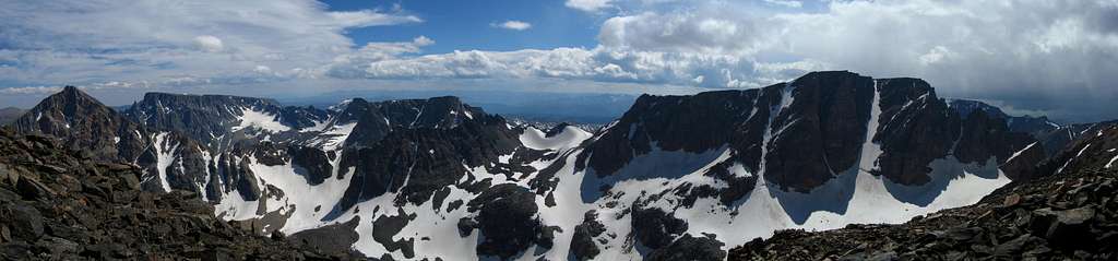 Castle Mountain on the right from Sundance Mountain. The NE Couloir is the big one at the right side.
Approach
For this route, access comes from the West Fork Rock Creek Trailhead located just outside Red Lodge, Montana. This is one of the more popular trailheads in the Beartooth Mountains and offers fantastic scenery. From the center of Red Lodge at the MT 308 and US 212 junction, head west 0.3 miles on US 212 and turn right onto the West Fork Road with signs for the Red Lodge ski area and measure distances from this turnoff. The road immediately comes to a Y, stay left and head up the paved road passing the Palisades Campground Road (gravel) on the right after 1.1 miles. Continue and enter the Custer National Forest after 2.8 miles and turn left to stay on the West Fork Road at 2.9 miles. Taking a right at this turnoff takes you to the ski area. Pass the winter closure gate at 5.2 miles, the Basin Lake Campground at 7.2 miles and the road turns to gravel at 7.4 miles. At mile 10.5, pass the Cascade Campground and reach the trailhead at mile 13 with an elevation of 7,890 feet. Here there is room for about 40 cars and 7 horse trailers and a pit toilet is available.
From the West Fork Rock Creek trailhead, start up the trail and take an immediate left with a sign for Quinnebaugh Meadows and Sundance Lake. Follow this nice trail for two miles through a burn area and reach the small Sentinel Falls at 8,400 feet just past a couple switchbacks. Continue up the more forested trail another 2.2 miles to Quinnebaugh Meadow and the junction with the Lake Mary Trail. The meadow offers fantastic camping and the first views of Whitetail Peak. Continue straight and cross the stream draining Lake Mary on a series of small logs or rocks and reach the first culvert bridge 0.6 mile past the Lake Mary junction at 8,950 feet. At this bridge a short boot path heads up this side drainage towards Senal and Dude Lakes. From here, continue up the flat and well groomed trail for 1.2 miles to a second culvert bridge that crosses Kookoo creek which drains Kookoo Lake. Beyond this point the trail steepens for the next 1.6 miles and climbs 500 feet over a series of switchbacks to a very nice footbridge crossing the West Fork Rock Creek to its SW side. Rather than crossing this bridge and continuing up the trail to Sundance Pass, continue up the valley on the left side to Shadow Lake which makes a great place to camp. It is advised to approach on this trail and camp so you can get an early start on the couloir.
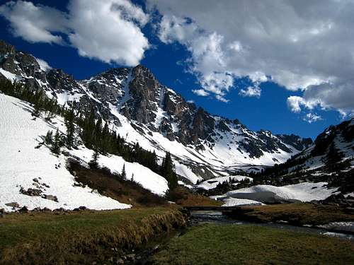 Whitetail Peak from the bridge over West Fork Rock Creek Whitetail Peak from the bridge over West Fork Rock Creek |
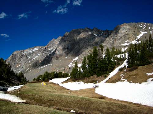 Looking back at Silver Run Peak from camp near Shadow Lake Looking back at Silver Run Peak from camp near Shadow Lake |
Route Description
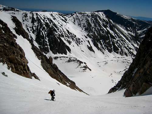
From Shadow Lake, continue up the valley passing Whitetail Peak and the Silt Lakes on the left side of the creek. After passing below the south face of Sundance Peak, ascend 600 feet up easy snow or talus to the northwest aiming for the base of the northeast end of Castle Peak. You will pass to the left and about 100 feet above a small tarn around 10,850 feet. Make sure you take the right, larger couloir rather than the smaller left one. At 11,300 feet reach the base of the couloir and put on the helmets and crampons. Climb the wide couloir to 11,500 feet where you reach the bergschrund. It's 30+ feet deep in the middle and stretches all the way across the couloir and too wide to step or jump over. There is usually a good snow bridge on the left end of the schrund that can be used to cross until mid-July but in later summer you may have to climb down into the crack at the far right edge next to a rock outcrop and then climb back out on a short bit of steep snow. If you are worried about it go in June and cross on the good bridge. Once above the bergschrund, continue up the left side of the couloir for 1000 feet until you reach the summit plateau. The couloir is steepest around and just above the schrund then mellows slightly about halfway up. The couloir never exceeds 40 degrees so most would not need a rope however simul-climbing with snow pickets as protection would work very well. Try to avoid the right side where there are more loose rocks that have been known to tumble quietly down the couloir. Keep a close eye above you!
Once you emerge onto the summit plateau, make a sharp left turn and head east across the gentle summit plateau for 0.2 mile to the highest point marked with a small cairn and a USGS marker. From the summit, the steps you just kicked in the couloir can be clearly seen as well as all the major Beartooth peaks from Wood in the north all the way to Granite Peak to the west. Red Lodge can be seen way in the lowlands to the east and Pilot Peak dominates to the south. Enjoy the summit as long as you can and try to be on your way down before noon. For the descent, take the standard South Slopes route to Omega Pass and past Omega Lake returning back to the valley floor and back to your camp.
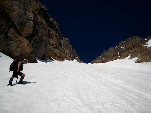 Climbing the NE Couloir Climbing the NE Couloir |
 Looking down with Sundance behind Looking down with Sundance behind |
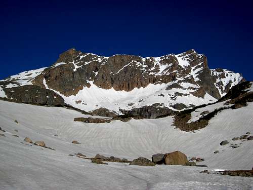 Castle Mountain from Silt Lakes Castle Mountain from Silt Lakes |
Essential Gear
Make sure you at least have a mountaineering axe and crampons. Good warm clothing is also a must and if anyone in your party is uncomfortable with moderately steep snow, maybe bring a light 30 meter alpine rope and a few pickets. This method will work well in this couloir in earlier season however in later season when much of the couloir turns icy an ice tool and a few screws may be required.
Map
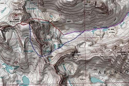 RED: Northeast Couloir Route - Moderate snow BLUE: Standard South Slopes Route - Class 2 PURPLE: West Fork Rock Creek Approach