
-
 5575 Hits
-
 76.66% Score
-
 7 Votes
|
|
Route |
|---|---|
|
|
32.18410°N / 111.0608°W |
|
|
Hiking, Scrambling |
|
|
Spring, Fall, Winter |
|
|
Class 3 |
|
|
Overview
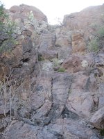
 Outcrop along the ridge
This is a short but very enjoyable ridge route that includes route finding, surviving vampire desert plants and a stiff 3rd class to low 4th class ascent of a rubble chute. The scrambling and route finding are delightfully relentless, the desert plant-life abundant and diverse and the views jaw-dropping. As with many desert peak scrambles, sometimes the easiest line on the rock is blocked by a well-positioned, blood-drawing desert plant. Wear appropriate protective clothing.
Take special care on the upper reaches of the mountain to note the weaknesses / passages used to overcome key obstacles, as these moves will be crucial to your return/descent route. This route is short, but mildly complex and not too heavily traveled, and paying close attention on the way up will pay dividends on the way down and reduce frustration.
Roundtrip Distance: 2.5 miles
Elevation Gain: 1,140 feet
YDS Rating: 3+ to 4
Getting There
 "Los Gatos Pass" area where you'll leave the trail
 Near "Los Gatos Pass"
• From I-10, south of Tucson, Hwy 86 / Ajo Way and head west on Ajo Way for roughly five miles
• Turn right / head northwest on S. Kinney Road for about one mile
• Turn right / head northeast on Sarasota Blvd north for ½ mile
• Turn right on a (currently unmarked) gravel road; if you enter Tucson Estates manufactured home community you have gone too far on Sarasota.
• Park in a gravel parking area where a walk-through gate permits access through the fence
View Larger Map
Route Description
When in doubt, stay as close to the spine of the ridge without cliffing out. In trending too low along the slopes you may find yourself in Hell: The Desert Edition (that is, steep, rocky terrain thickly populated by spine-covered plants.) Few cairns can be found along the lower route, but keen route-finding eyes will find faint game-or-foot paths to follow. These routes through the prickly cactuses and other thorn-bearing plants are quite welcomed! Higher on the route you will encounter small cairns pointing the way toward weaknesses in El Gato’s upper cliffbands.
 View of the ridge from neighboring "Little Cat Mountain"
• From the parking area, go through the gateway in the fence and head northeast on wide trail / old road.
• Follow this path as it narrows to a wide trail for less than one mile to “Los Gatos Pass,” the low saddle between Cat Mountain and “Little Cat Mountain” (UN 3330).
• Stay on the trail just past two rusty red metal posts – good markers for departing the pass – for a good view of the Northwest Ridge. (Note: From this point, it took me roughly 1 hour to reach the summit at a moderate pace.)
• From here you will pick your own way to the southeast up the Northwest Ridge of Cat Mountain. Staying north of the ridge will help you stay cool and in the shade and also seemed to me to provide for easier terrain.
• As you get higher, cairns start to appear here and there indicating weaknesses in the upper cliff bands of Cat Mountain.
• As you near the final summit push, an exciting obstacle presents itself. This rock couloir / rubble chute is near vertical in places and is a stiff 3rd class to low 4th class scramble. The holds are plentiful, but the going is steep and water may be present here in certain conditions (the rock was wet during my February visit). A fall here, while unlikely, could have unpleasant consequences, so take your time and be mindful of your foot and hand placement.
| Chute from bottom | Rubble Chute Close-Up | Upper Rubble Chute |
|---|---|---|
 |  |  |
• After topping out of the gulley, follow a ledge system around a west/northwest facing outcrop that leads to a weakness up a small sub-summit. Take note of where you exit onto the final summit area opening here, as this will be key to your descent.
• Gain this rise (sub-summit), then the summit will loom close-by to your southeast.
• Head for the fiberglass rock, ascending a gentle pile of smooth rock en route.
• Take in the views, but remember to not touch/damage/bother the “faux boulder” housing the Pima County Sheriff’s communications repeater.
• Carefully retrace your route back down along the spine of Cat Mountain to “Los Gatos Pass,” then on out to the parking area.
Sequential Route Photos - Upper Route Above Rubble Chute
 The summit is in sight - the view of the summit from the sub-summit.
 Just a little further - ascending a few smooth rocks will carry you to the summit
  Approaching the summit of Cat Mountain; Note the faux boulder on top, housing a Pima County Sheriff's communications repeater.
Essential Gear
 Suburbs from high on Cat Mountain
• Trail map (Trails Illustrated #237 – Saguaro National Park would meet most needs)
• Scrambling gloves (gardening gloves would do in a pinch)
• Clothing to protect your skin from rocks abrasions and vampire desert plants (including long pants and long sleeves, though gaiters may be useful as well).
• Sunscreen
• Abundant drinking water and salty snacks