
|
|
Route |
|---|---|
|
|
37.57770°N / 105.4859°W |
|
|
Mountaineering |
|
|
Fall |
|
|
Most of a day |
|
|
5.6 (YDS) |
|
|
Yes |
|
|
III |
|
|
Overview
Ormes Buttress is the most logical way up Blanca Peak’s magnificent, sweeping north face. It is the prominent buttress extending from the Blanca-Ellingwood nordwand cirque almost to the summit, meeting up with the standard northwest slopes route, originating from Lake Como, a few hundred feet from the summit. The buttress is named after Robert Ormes, the first ascentionist; he was a Colorado Springs climber, the protégé of Albert Ellingwood (the finest American climber of his generation).The route offers an enjoyable climb, wonderful alpine ambiance, & a variety of challenges on its way up the mountain:
• It’s big: at ~1,500 ft. tall, you’ve got to move fast to make it up in a reasonable amount of time (simul-climbing as much as possible while maintaining a good comfort level highly encouraged); this urgency is compounded by the usual threat of Rockies thunderstorms, and, given that Blanca Peak is the 4th highest peak in Colorado, it has an abnormally high probability of attracting storms. Also, unless you have a prearranged shuttle waiting for you at a different trailhead (necessitating an up-&-over approach to the climb), the descent is non-trivial; the easiest way back to the Huerfano Valley is circuitous 4th class; the most direct way back is via
Gash Ridge, 5.2, likely for the first time…
• Retreating would be problematic- not only is the route huge (necessitating A LOT of rappels, if one HAD to), there are, in many places on the route, few places to set up an anchor- there are oftentimes few anchor-worthy boulders to sling; the rock is compact, frequently devoid of any suitable cracks for pro’; & it is frequently downward-facing (no positive edges to lasso). Retreating from the route NOT recommended!
• As alluded to above, the rock can pose problems for those trying to climb up it. It’s compact, meaning there are oftentimes not-so-great protection possibilities (I remember one stretch where I had to go for some 50’ or so before I could find anything to use as an anchor… It was easy climbing, but if 5.6 is your upper leading limit, not so ideal…); it’s oftentimes downward-sloping, meaning hard to find positive edges to climb (& in a few cases, huge widow-makers that you want to climb that look like they’d come right off if you were to pull too hard :( ), & while it’s certainly not the worst rock, & ain’t Yosemite either…
• As stated earlier, if you want to get back to a car in the Huerfano Valley, you’re looking at a technical downclimb- likely for the first time, on convoluted terrain, & most likely with some sketchy sections to boot. If the weather turns to shit before or during this endeavor, you’re NOT gonna love it.
Still interested? Read on…
Getting There
Approach as per the Huerfano Valley. From the trailhead to the start of the climbing, allowing 2.5-3 hours is recommended.
This approach info (getting TO the trailhead) shamelessly pilfered from sunnysummit's Huerfano River Trail page:
From Denver travel South on I-25 to Walsenburg. Exit at Walsenburg and follow Hwy 69 westerly to the town of Gardner. Continue westerly through Gardner a mile or so to an intersection where Hwy 69 and CR550 intersect. Go due West on 550 until the road intersects with CR570 at which point 550 becomes CR580. Continue Westerly on 580 until you drive through the Singing River Ranch. The property surrounding the ranch is private and the road becomes rough, but passable above it. There is camping along the road above the ranch and very good camping at the roads end.As per the Huerfano Valley.
FROM the trailhead:
Start at the Lily Lake Trailhead. Take the Lily Lake Trail (#1308) up the Huerfano (orphan boy in Spanish) Valley. At a certain point, the trail will start to switchback up towards Lily Lake. At the first major switchback (where the trail makes a hairpin turn), set off cross-country; it’s about 2.5 mi. from the trailhead to this point. Remember this area, as you’ll need to find the trail on the return. If you reach the obvious, large campsite, either cut through the forest at this point, or go back a minute or 2 to get back to the aforementioned hairpin.
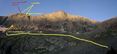
Once through the forest & in the huge talus field, head across the cirque toward the impressive wall that forms the north face of the Blanca massif (see photo); Blanca is the obvious, impressive, monarch of the group, & Ellingwood Point the next-most impressive subsidiary summit (to the R), connected to Blanca by a graceful knife-edge. Head left towards the obvious toe of the buttress. It might be necessary to cross snow to get to the buttress early season, or after high snow years.
Route Description
Go up the buttress, following the easiest path (follow natural weaknesses as they present themselves). It should be noted that there are so many individual possibilities up the buttress that a more generalized description is probably the most useful way of describing things, with notable sections as I found them described more in detail as useful. We found the most obvious line(s) of weakness to generally be on the left-hand side of the buttress.We pitched out the first 3 or so pitches, which ranged from 4th class to mid-5th.
Pitch 1 is loose 4th.
Pitch 2, I would say that (the way we went), is the psychological, & perhaps the physical, crux of the route: Going (climber’s) left of a belay alcove, the leader must find a way through a short overhang (3 or 4 short sections of 5.6) comprised of detached blocks/flakes of dubious quality, & while offering great handholds that one might initially be tempted to use to get above (or place pro’ behind), upon closer inspection look like they would pry off if weighted (either trying to pull oneself up on them or if a cam expanded during a fall)- this would be highly undesired…
At approximately the midpoint of the buttress, after maybe 500 or so vertical ft. (3 pitched-out ropelengths for us) from the base, the slopes will mellow out to 2nd/3rd class scrambling through an inclined rocky meadow-esque section. Simul-climbing or unroping altogether is highly encouraged to save time, until the next steep section is encountered, another few hundred ft. above.
At a certain point, the buttress will steepen up again. The approximately upper 1/3 of the buttress (400’ or so vertical) ranges from consistent 4th to easy 5th. A prominent prow forms the (climber’s) R-hand side of the buttress at this point. While this certainly looks climbable (it looked to be mid 5th), it can be bypassed on the L for easier climbing to save time (which we did), especially if questionable weather is approaching.
The last few hundred ft. will turn to 4th class, then eventually 3rd, as the buttress flattens out & becomes a more well-defined ridgeline. Shortly after this (your speed should correspondingly increase), it will finally merge with the northwest ridge (the standard route, approached from the Lake Como basin west of the peak. From here, it’s a mellow scamper (2nd/3rd class) to the summit (after starting, it’s also the easiest escape option- fast 3rd class to the basin below (you’d have to return to descend back to the Huerfano Valley, but it’d get you out of harm’s way for the time-being).
Descent
The most direct descent back to the Huerfano Valley is via Gash Ridge. This involves much 4th, some 3rd & a few sections of low 5th. If you were comfortable with getting up Ormes Buttress, this is likely the most expedient way to get off of the mountain. This is a fairly sustained downclimb, however, with notable exposure. I'd highly recommend familiarizing yourself with the route beforehand; it is easy to pick a descent that will eventually cliff out (i.e. make sure to pick the right one!). Check out the SP page for Gash Ridge here. The rock on Gash Ridge is surprisingly solid, & would make a fun ascent route in its own right.A lengthier, 4th class (the easiest way between the Huerfano Valley & the top of Blanca) alternative is to take Blanca's S ridge; it is possible to get to the northernmost Winchell Lake at some point. From here, a traverse can be made, then climbing, to get to the notch whence one would descend from Gash Ridge. I have not done this route, so I can't provide any good personal information about it.