World Wind
| Page Type | Gear Review |
|---|---|
| Object Title | World Wind |
| Manufacturer | NASA |
| Page By | redsplashman23 |
| Page Type | Jan 24, 2007 / Aug 1, 2011 |
| Object ID | 2056 |
| Hits | 4487 |
| Vote |
Product Description
World Wind allows one to zoom to any place on earth with a satellite view to any place on our planet. You can do so with rich 3D imaging. In some ways it is even more powerful than Google Earth. It is also free! It can be downloaded here.Features
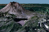
3D EngineWorld Wind allows the user to zoom in with satellite coverage to any place on Earth. This 3D imagery is just as good as if you were really there.
Blue Marble
NASA World Wind has a copy of the Blue Marble, a great true-color image of Earth as seen from NASA's Earth Observatory: the Blue Marble. It can be seen with 1 km/pixel resulution.
Land Sat 7
This feature allows one to continue to zoom in past Blue Marble levels and view deteailed LandSat 7 imagery.
SRTM
World Wind combines LandSat 7 imagery with Shuttle Radar Topography Mission (SRTM) Data, helping to display a view of Earth from eye level.
In addition, World Wind can also exaggerate these views so one can pick out the details with ease.
GLOBE
World Wind is capable of browsing and displaying Globe data. For example, one can download today or any previous day's temperatures around the world. You can also view berometric pressume, cloud cover, or rainfall.
Country & (USA) State Borders
Borders that trace every state and country are included with World WInd. As you zoom in, the more precise these boundaries become.
Mountain ridges and rivers can be viewed where they have formed political boundaries of today.
Place names
Full catalogs of countries, capitals, counties, cities, towns, and even historical references are included with World Wind. Mouintain ranges, summits, springs, rivers and other bodies of water are also seen.
It's likely you can find your own town no matter how large or small it is with World Wind.
These are only some of the many features to be utilized with NASA's World Wind.
System Requirements
- Windows 2000, XP Home, or XP Professional
- Intel Pentium 3, 1 GHz, or AMD Athlon or higher
- Intel Extreme Graphics 2
- DSL / Cable connection or faster
- 256 MB of RAM
- ATI Radeon 7500
- 3D Graphics Card
- nVidia GeForce 2 Ultra
- 2 GB of disk space
Images
 |
Reviews
Viewing: 1-3 of 3 |

redsplashman23 - Mar 8, 2007 2:00 pm - Voted 5/5
Did I mention
It's also free! Download it Here.

Nanuls - Aug 10, 2007 8:28 am - Voted 5/5
Great utility
A great utility with a much better coverage than Google Earth, which tends only to have the most visited or lived in areas in any kind of useful detail. I'm still sceptical about the usefulness of these programs as a tool for mountaineering though, as there are much better products on the market that can be bought, and at the end of the day you get what you pay for.
Viewing: 1-3 of 3 |
redsplashman23 - Feb 19, 2007 8:56 pm - Voted 5/5
Great Program