
-
 8365 Hits
-
 83.69% Score
-
 17 Votes
|
|
Mountain/Rock |
|---|---|
|
|
46.41561°N / 10.61829°E |
|
|
Alta Valtellina |
|
|
Mountaineering |
|
|
12149 ft / 3703 m |
|
|
With the courtesy of the former owner: Marco 969
Overview
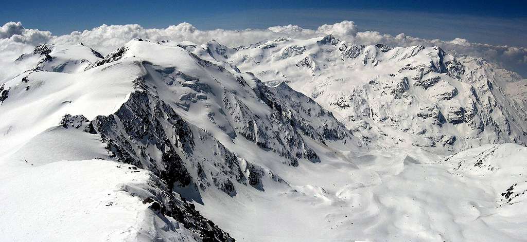
"Palon de la Mare" is a mountain belonging to the chain "Ortles-Cevedale group" in the Italian "Stelvio national park".It's the fourth mountains of the area in height. From the summit it is possible to admire the wonderful scenario of the mountains range of that region, like "Ortles", "Gran Zebrù" and the "Ghiacciaio di Forni".
Palon is complitely surrouded by glaciers, and offers a rocky flank only on the south side. It is separated from the "Monte Rosole" by the "Col de la Mare" 3442m and from "Monte Vioz" by the "Passo della Vedretta Rossa" 3405m.
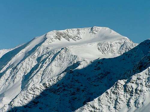
Palon de la Mare from Monte Pasquale
The normal route is easy, and climbers have only to be carefull about few crevasses! It's very commonly climbed, expecially during the spring due to the easy approach, smooth flanks and the closeness to the carpark.
Skimoutaineering is absolutely the best way here. Good accomodations permit it from march to may.
Be carefull: the area has been theatre of battles during the first world war. In case you find out any old war weapon, do not touch it and call the police guards.
Palon de la Mare west side
Getting there
From Milano by car (IT): Statal route "Vallassina" number 36 to Lecco and then to Colico (north side Como lake) and then Stelvio road route to Morbegno, Sondrio, Tirano and then to Bormio (three hours). From Bormio only 12 Km to Santa Caterina Valfurva and then 8 Km to Refuge ai Forni, where is situated a free parking area. From Milano by train or buses (IT): Take a train in the Milan Central station destination Tirano and then a bus to Santa Caterina (4 hours). From Alto Adige (IT): From Bozen (Alto Adige on the highway between Innsbruck and Verona) to Merano by main route and the by local route through Venosta Valley follow the signals to Stelvio mountain pass (2700 meters, the highest mountain pass reaching by car, open only in the summer period). From here to Bormio (3 hours and half from Bozen, Stelvio pass requires 44 bends to go up and 15 to go down). From Bormio only 12 Km to Santa Caterina Valfurva and then 8 Km to Refuge ai Forni, where is situated a free parking area. From Saint Moritz by car (CH): Go to Pontresina and then follow the signals to Bernina pass. Turn left when you look the indication to Livigno (I) through Forcola pass (open only in summer period) and then from Livigno through Foscagno pass (2200 meters, open all the year) to Bormio (3 hours). From Bormio only 12 Km to Santa Caterina Valfurva and then 8 Km to Refuge ai Forni, where is situated a free parking area. From Santa Maria (Val Munstair) (CH): Follow the signals to Giogo di Santa Maria (Pab Umbrail) on the border between Switzerland and Italy and then to Bormio (1 hour and half, border near Stelvio pass, open only in the summer period). From Bormio only 12 Km to Santa Caterina Valfurva and then 8 Km to Refuge ai Forni, where is situated a free parking area. From Austria or Germany by car: On highways via either Innsbruck or Bregenz to Landeck and then following Staatsstraße S 13 to the italian border at the Reschenpass / Passo di Resia . There the Vinschgau / Val Venosta valley starts that represents the northern border of Ortles-Cevedale group. At Prad the Trafoi valley starts that leads either to Sulden / Solda or via Stilfser Joch / Passo di Stelvia to Bormio. From Bormio only 12 Km to Santa Caterina Valfurva and then 8 Km to Refuge ai Forni, where is situated a free parking area. From Ponte di Legno (IT): Through Gavia pass, dangerous route (very small) open only in the summer period. From Santa Caterina Valfurva to the Refuge ai Forni, where is situated a free parking area. |
Routes Overview
"Normal route" From the refuge "Ghiacciaio dei Forni" (2.170 m) walking trough an easy path in one hour to "refuge Branca" (2.500 m). From the refuge follow the edge of the moraine, until it's end. Turn left and get into a couloir usually snowy, that takes to the glacier at the foot of the moutain. Go across the glacier (crevasses warning) with a right turn pointing to the ridge that descends from the top. Once reached the ridge, climb it easily until the summit. Fror the "ski route" follow the same way. "Cevedale-Palon traverse" Very fine route that permits to climb two summit. From the top of Palon de la Mare, follow the ridge on the opposite side of the ascent route. The "bivouac Colombo" will be clearly visible above the saddle. From the saddle, get down on the glacier on your right side (above Pejo valley). Walk on the glacier without losing altitude and pointing to the summit of Cevedale that will be visibile soon. Climb the glacier while getting the saddle between the two summits of Cevedale. For the main summit turn back on the ridge to west direction. From the summit of Cevedale you can get down to the "refuge Casati" or "refuge Pizzini-Frattola" "Vedretta Rossa" route From "Malga Mare" 1972m, over a wooden bridge, heading towards a clear and steep channel approximately 300m high and east-facing and climb it. At the altitude of 2400m follow the less steep valley, almost flat up to 2800m, where the north west you see the top of Palon de la Mare, go to the glacier below the peak (Vedretta Rossa) and navigate to the north under the same. Head of a hill at an altitude of 3550m. With steep saddle you get the large panoramic view of the glacial "Valle dei Forni" and related summits. From here one last large slope leading to the top. |
Accomodations

refuge Casati
Refuge Casati-Guasti 3254m
Open from 1 july to 15 september
Tel. 0342-93.55.07
Keeper: Renato Alberti - Via S. Antonio 40 - S. Antonio Valfurva (So). Tel. 0342-94.57.59 Fax 0342-92.50.75
Owner CAI Sez. di Milano. Tel. 02-86.46.35.16.
Place 260, in winter 12

refuge Pizzini-Frattola
Refuge Pizzini-Frattola 2700m
Val Cedec
Open from mid march to end of april, and mid june to mid september
Tel. 0342-93.55.13
Keeper: Claudio Compagnoni - S. Antonio Valfurva (So). Tel. 0342-94.56.18
Owner: CAI Sezione di Milano. Tel. 02-86463516
Places 52, in winter 12

refuge Branca
Refuge Branca 2487m
Val Cedec
Open from mid march to mid april, and from mid june to mid september
Tel. 0342-93.55.01
Keeper: Eugenio Alberti - S. Caterina Valfurva (So). Tel. 0342-93.53.50
Owner: CAI Sezione di Milano. Tel. 02-86.46.35.16
Places 120, in winter 8

refuge Larcher
Refuge Larcher 2608m
Valle della Mare
Open in april and from mid june to mid september.
Tel. 0463-751770
Keeper: Guida alpina Oreste Casanova Tel. 0463-753144
Owner: CAI-SAT - Via Manci 57 - 38100 Trento. Tel 0461-981871
Places 80, in winter 20

bivouac Colombo
Bivouac Colombo 3485m
Cresta del Monte Rosole
Open permanently
Owner: CAI Sezione di Seregno - Gall. Mazzini 10 - 20038 Seregno (Mi)
Places 9