
-
 12294 Hits
-
 77.48% Score
-
 8 Votes
|
|
Route |
|---|---|
|
|
32.77000°N / 16.93°W |
|
|
Download GPX » View Route on Map |
|
|
Scramble |
|
|
Most of a day |
|
|
Walk-Up |
|
|
Overview
 On the tunnel route through the Pico das Torres West Face On the tunnel route through the Pico das Torres West Face |
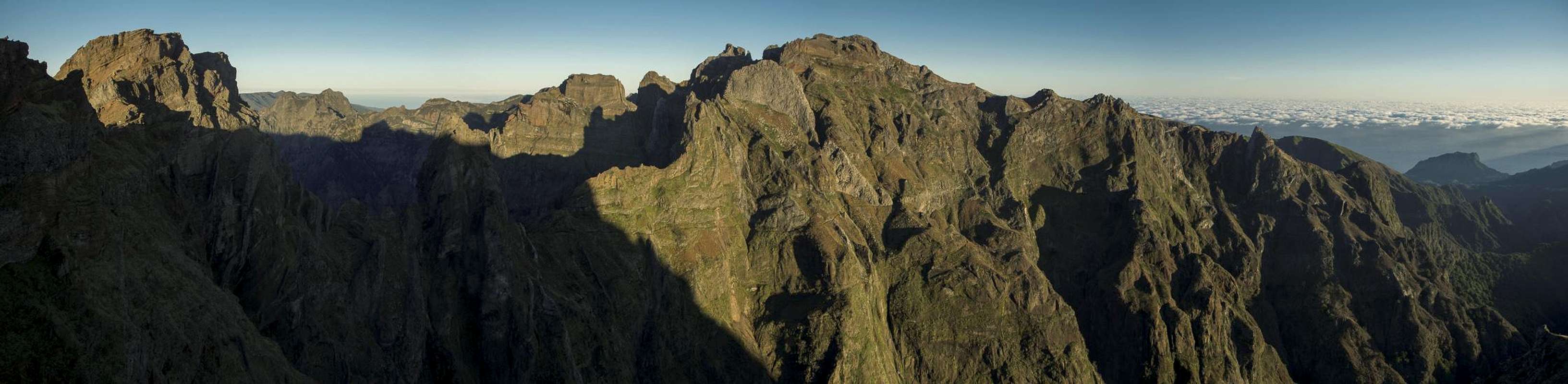
This is easily the most impressive hiking route can find on Madeira and probably it is among the top dozen such routes on the planet. It follows an old camino which connects Madeira's highest mountains and from which you can reach the summits of all of them. The trail runs along a ridge which separates the Nogueira Valley in teh east from the Gato Valley in the west and what a ridge it is! Vertical drops all around, the sentinel of Pico do Gato, guarding it high above and blocking the way so that the path follows a tunnel cut through the tower. In the central part there are two branches, the tunnel route in the west, which follows a system of ledges and tunnels through the Pico das Torres west face, the eastern route, which passes the same mountain to the east, also on exposed ledges. The recombined routes carry on along the ledges up to the final ascent to Casa do Abrigo and Pico Ruivo.
The route with both its branches is very exposed. However, much of it runs along broad paved paths with lots of staircases strewn in between. Almost everywhere there are railings (rather thin cables), which at least project the notion of protection. The main danger is due to the possibility of rockfall, which on the ledge systems can hardly be avoided. The route - or rather the two branches in its middle - has a history of being closed due to rockfall, especially after heavy rains, which loosen the soft rock around Pico das Torres. It is advisable to refrain from hiking the route if you find it closed by warning signs.
Naturally the hike can be done both ways. The northern trailhead is Achada do Teixeira.
Approach
  |
- From the airport take ER207 to Santo da Serra, switch to ER102, direction Camacha and at Quatro Estradas switch to ER202 to Pico do Arieiro.
- From Funchal take ER103 through Monte to Ribeiro Frio. At Poiso switch to ER202 to Pico do Arieiro.
Route Description
 Summit view Pico do Arieiro
- General:
- Start altitude: 1813m
- Summit altitude: 1861m
- Prevailing exposure: All directions
- Type: Hike and Scramble
- Protection: Lots of thin cables have been installed as railings
- Start altitude: 1813m
- Effort: 2 - 1000m elevation gain both ways
- Power: 2 - Very steep staircases
- Psyche: 2 - Scary, even critical in the rockfall sections
- Difficulty: 1 - Easy
- Orientation: 1 - Marked and easy.
From Pico do Arieiro to Pico do Gato
From the parking lot at Pico do Arieiro sttart by hiking through the snackbar / souvenir complex. To your right is the big radar installation, up front is the Pico do Arieiro summit. After visiting the summit column, turn back for a few metres and turn west onto a paved path, which leads in the general direction of Pico do Cidrao. It descends into a saddle before reaching the east wall of Pedra Riga, through which a ledgeway leads. The ledge leads to the lookout of Ninho da Manta, from which you can see Pico Ruivo for the first time.
 |  |  |
Return from the lookout and now ascend a steep stairway which leads across a shoulder close to the Pedra Riga summit. Another protected staircase heads steeply down into a saddle, which separates Pedra Riga from Pico do Cidrao. The path now leads into the north face of the latter mountain (if you want to climb it look out for an unmarked path heading off to the left) and descends it by a very steep staircase, which kind of hovers above the Ribeiro Gato Valley. After a few switchbacks the path turns and now heads out on the narrow ridge, dominated by the tower of Pico do Gato. A stairway leads through a window in a basalt wall and finally you touch the base of the tower.
 |  |  |  |
Here a tunnel of 200m length awaits you. It is straight so that you can see the end but nevertheless a muddy ground and a rough low surface on the top require all your attention. A few steps after the tunnel the route separates.
Eastern Branch
(Hiked in 2003 - not many memories remain)
The right hand path leads through the Pico das Torres south face, which is only nearly vertical. It stays level while circling the southernmost of the Pico das Torres Towers. Afterwards it runs along an exposed, slightly rising ledge, after which a set of gullies need to be negotiated (rockfall area). After the gully a long steep stairway leads to a saddle to the east of Pico das Torres, the highest point of the eastern branch. Now, the path descends steeply through the north face before levelling out on a ledge which takes you to the intersection with the tunnel route - at the exit of the last of these tunnels.
 |  |  |
Tunnel Route
The tunnel route is the shorter but certainly more impressive of the two branches. From the intersection north of Pico do Gato a ledge immediately leads into the vertical west face of Pico das Torres. You turn a corner and suddenly towers rise up all around you. The route first leads to a little platform / balcony with good views. Descending towards the east you'll reach the first of the tunnels, 100m long but with a bend in the middle. You definitely need flashlights here.
 |  |  |  |
After the tunnel a ledge (cut into the wall) takes you through the west face towards the base of one of the promontories (rockfall area). It leads on slippery stairs right across the feature, ending about 100m higher. Some more ledges and you stand before the long Pojo Maledo Tunnel. It is straight but lies directly in the usual wind direction so that it gets cold even in the most perfect weather. Three more short tunnels later you reach the intersection with the eastern route.
The ascent to Pico Ruivo
 Summit view Pico Ruivo with Casa do Abrigo
Now on the eastern side of Pico Ruivo, the path follows a broad ledge for about half an hour before it rises to meet the normal route from Achada do Teixeira. From the intersection a paved path leads in five minutes to Casa do Abrigo, the mountain hut of Pico Ruivo. Pass the hut to the south and you find yourself on the camino which connects Achada do Teixeira with Boca da Encumeada along the whole of Madeira's weather divide. But already five minutes later a path turns off to the left, leading directly to the Pico Ruivo summit with its lookout platforms and boardwalks.