
-
 7318 Hits
-
 85.87% Score
-
 21 Votes
|
|
Mountain/Rock |
|---|---|
|
|
46.60533°N / 10.30514°E |
|
|
Hiking, Skiing |
|
|
Summer, Fall, Winter |
|
|
9682 ft / 2951 m |
|
|
Overview
 Piz Dora and Piz Daint Piz Dora and Piz Daint |
The Rhaetian language is one of the oldest langauges spoken in Europe. It has latin origins, dating back to the times, when Roman armies traversed the Alps in order to conquer the people in the north. Over time local dialects were mixed into it, so that nowadays the Rhaetian tongue may differ from valley to valley. After the Romans other conquering people or armies travelled on through, leaving their imprint on the landscapes they came through. In the end German- and Italian speaking people took over all but eliminating the old languages. However, in the remotest part of the Alps several linguistical enclaves linger. The two largest are the Ladinian areas around the Sella Group in the Dolomites and the canton of Grischun / Graubünden around the Sesvenna Group. Today efforts are undertaken to revive the language in both regions by teaching them at schools.
While in everyday life the languages more and more have to make way for the official German or Italian languages the names of mountains and valleys, the whole geography, still bear the old Rhaetian names. While in border regions there might be mountains with two or more names in the heartland you will still find the original ones - and it is certain that they will survive even if the everyday use of the language diminishes further. In Graubünden - or Gischun, to keep up with the Rhaetic name - there are hundreds of mountains with those wonderful names, which make you wonder, how they might be pronounced.
  |
Near Pass dal Fuorn / Ofenpass - in the depth of Val Müstair / Münstertal there are two mountains - easy to pronounce, easy to climb as well - which both almost reach 3000m and which can serve for a little SummitPost Rhatian lesson. Their names? Piz Daint and Piz Dora. In English these names stand for the inner (daint) and outer (dora) peak, all relative to their position at the end of Val Müstair. The naming of daint (or dadaint) and dora (dadora) is rather common for mountains in the area.
With 2968m Piz Daint is the higher of the two mountains while Piz Dora reaches 2951m. Both are huge broad pyramids, which rise out of the valley for roughly 1500m. Thus the climb of both of them is a major undertaking, long but far from difficult. Piz Dora is located to the east and connected by a narrow curving ridge with the pointier Piz Daint. Both belong to the Umbrail Group of the Ortler Cevedale Group and are its northernmost outposts.
 Piz Daint Piz Daint |  Piz Dora Piz Dora |  Piz Daint Piz Daint |
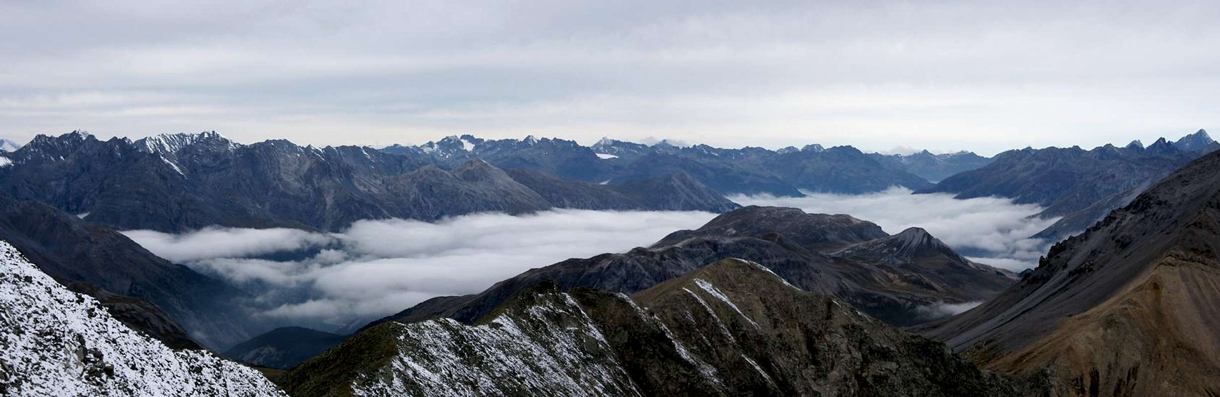
Piz Dora is famed for its summit view - and rightly so. Located almost at the western end of the Eastern Alps the views take you all across the central part of the large European mountain range. Veritably hundreds of peaks are visible from its mountaintop. Naturally the close-by Ortler and Sesvenna Groups are directly on display as well as the Albula Group in the west. In the southern distance the Bernina Group rises like a chain of huge glaciated domes.
In winter, Piz Dora is a popular ski tour destination.
 Piz Dora Piz Dora |  Piz Dora east ridge Piz Dora east ridge |  Piz Dora, Piz Daint Piz Dora, Piz Daint |
The normal route to Piz Dora is an easy hike - if a bit longish. It starts at Tschierv in Val Müstair at 1600m and leads to the summit via its southern east ridge. This ridge goes on forever ending at Santa Maria in Val Müstair. If you bring enough time you should go as far as possible on the ridge which offers wonderful views across the valley.
360° Summit Panorama
 |
Getting There
 Piz Dora and Piz Daint as seen from Tschierv
The trailhead for Piz Dora is at Tschierv, a village in Val Müstair. The village is located not far from Pass dal Fuorn / Ofenpass.
From South Tyrol / Alto Adige
- Take SS38 from Bozen / Bolzano through Meran / Merano and Vinschgau / Val Venosta.
- At Spondinig / Spondigna turn onto SS40 to Schluderns / Sluderno.
- Here turn onto SS41 which leads into Switzerland.
- Called B28 there the road leads to Santa Maria, and on to Tschierv.
From Grischun / Graubünden
- Take B28 across Ofenpass / Pass dal Fuorn until you reach Tschierv.
From Austria
- From Landeck take B180 across Reschenpass / Passo di Resia into South Tyrol / Alto Adige.
- The road, SS40 in Italy, takes you to Mals / Malles Venosta.
- Here, turn onto a side road through Laatsch / Laudes, which heads for Switzerland, joining SS41 several kilometres in front of the border.
- In Switzerland follow B28 to Santa Maria and Tschierv
Red Tape
![Huge raven]() Huge raven paying us a visit on the Piz Doraa summit
Huge raven paying us a visit on the Piz Doraa summit
There is no red tape to speak of. On the lower slopes you find a number of fences, closing in cattle or horses. Keep them shut.Accommodation
Weather Conditions
Maps & Books
Maps
- Unterengadin-Nationalpark / Bassa Engadina-Parco Nazionale
Kompass Map WK 98
1:50.000
ISBN: 3-85491-331-1
Books
- Unterengadin
R. and S. Weiss
Rother Verlag
ISBN: 3-7633-4043-2
- Ortleralpen
P. Holl
Alpenvereinsführer
Rother Verlag
ISBN: 3-7633-1313-3
- From Landeck take B180 across Reschenpass / Passo di Resia into South Tyrol / Alto Adige.
