
|
|
Trailhead |
|---|
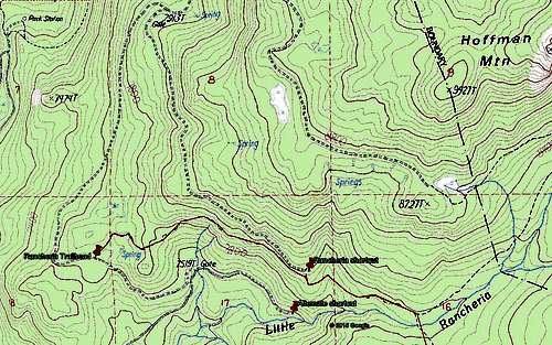
The Rancheria Trailhead -- commonly used for peaks such as Tehipite Dome, Tunemah and Finger Peak -- can be shortcut by about a mile, saving some 300' of climbing on the way in:
![Rancheria Trailhead Shortcut]()
Rancheria Trailhead Shortcut
Drive past the Rancheria Trailhead for 1.5 miles, then take the right fork. The "gate" marked at this point on the topo map is broken. Continue on 1.6 miles to a rough parking area at the end of the road. Wade downhill through brush for a few yards to reach the trail. The parking area is invisible from the trail, so be sure not to miss it on the return. The road is in decent condition (as of July 2015) and can be used by passenger cars.
There is a functioning gate before the Rancheria trailhead, shown incorrectly on the map -- at the road split before the trailhead, it's on the left fork, not the right fork. The right fork has no barriers; it goes 0.5 miles to a parking area by Little Rancheria Creek. If the gate is closed this would provide an alternate route, also saving about a mile of trail. However it would require a bit of cross-country travel, and is at the same elevation as the trailhead.