
-
 8742 Hits
-
 87.31% Score
-
 24 Votes
|
|
Route |
|---|---|
|
|
45.93275°N / 7.77493°E |
|
|
Mountaineering, Ice Climbing |
|
|
Summer |
|
|
Half a day |
|
|
Alpine F+ |
|
|
Overview
Roccia Nera Normal Route
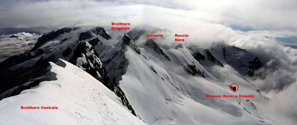
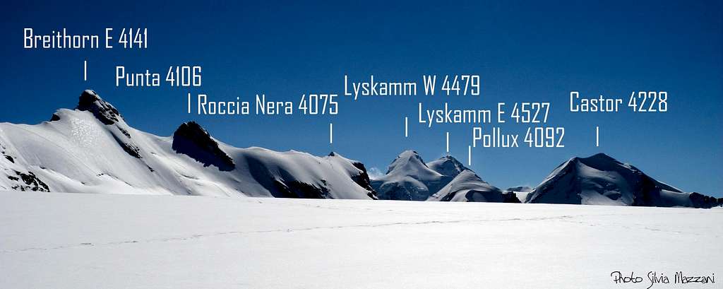
Roccia Nera 4075 m is an imposing summit belonging to the Pennine Alps and located on Italy-Switzerland border, between Gemello Orientale del Breithorn 4106 m to the West and Polluce 4091 m to the East, from which it's separated by the col named Porta Nera or Schwarztor (Black Door) 3725 m, a snow saddle connecting the Great Verra Glacier on the South side with the Schwarzegletscher on the North side. On the italian side the peaks dominates the Great Verra Glacier and the high Northern head of Val d'Ayas.
Roccia Nera - meaning "Black Rock" - is also known with the names Schwarzruken or Schwarzfluh (in German) and Roche Noire (in French). The origin of the name Roccia Nera comes from the dark, majestic and vertical rock wall, resembling the prow of a ship, that the mountain projects over the underlying Porta Nera. On the left, unlike, the mountain shows a completely snowy and icy slope up to the top, along which it develops the Normal route of ascent, located on the italian side.
Roccia Nera Normal route can be approached by two possible starting points. The first route, shorter, starts from Rifugio Guide del Cervino, the arrival of the cable car from Breuil-Cervinia to Plateau Rosa. The second route, longer, starts from the high Valle d'Ayas, from Rifugio Mezzalama o from Rifugio Guide d'Ayas at Lambronecca. Both the approach routes converge near the Bivouac Rossi and Volante 3750 m, located right at the base of Roccia Nera Normal route.
Getting There
The starting points are Breuil-Cervinia (Valtournenche Valley, AO) or Saint Jacques, a hamlet of Champoluc (Val Ayas, AO) or Zermatt for the ascent from the swiss side of the mountain.
Getting to Breuil-Cervinia
Breuil-Cervinia is situated at the end of Valtournenche Valley.
- From Turin and Milan: follow the A5 Motorway and exit at Chatillon (Aosta East). Follow the road 406 rising along the Valtournenche Valley, reaching Antey Saint André, Valtournenche and finally Breuil-Cervinia m. 2006 (27 km. from Chatillon). A cable-car station is situated downtown and reaches Plan Maison m. 2548 and Testa Grigia m. 3480 on Plateau Rosà. - From France: you can reach Aosta through Mont Blanc Tunnel or Little St. Bernard Pass.
")
- From Switzerland: you can reach Aosta through the Great St.Bernard Tunnel or the Great St.Bernard Col.
Getting to Saint Jacques
- From Turin and Milan: follow the A5 Motorway and exit at Verres-Champoluc, then take the Val d'Ayas road to Champoluc.

Getting to Zermatt
Zermatt is the last village at the end of Matter valley, which branches off Rhone valley at Visp.
- Coming from Italy take the road number SS33 / 9 over Simplonpass to Visp - Coming from Zürich region take highway 6 and 8 and the road to Kandersteg for Lötschberg railway transportation to Goppenstein, Lötschberg road and road number 9 to Visp. - Coming from Geneve / Lausanne region highway and road number 9 brings you to Visp.
At Visp follow the signposts for Zermatt to Stalden, Sankt Niklaus and Täsch. Park your car there and take the train shuttle from Täsch to Zermatt.
Route Description
Roccia Nera Normal routes - italian side
Difficulty: F+ (Alpine) - 40° the snowy ramp
Difference in level: 600 m from Testa Grigia, 1070 m from Rifugio Mezzalama, 650 m from Rifugio Guide d'Ayas
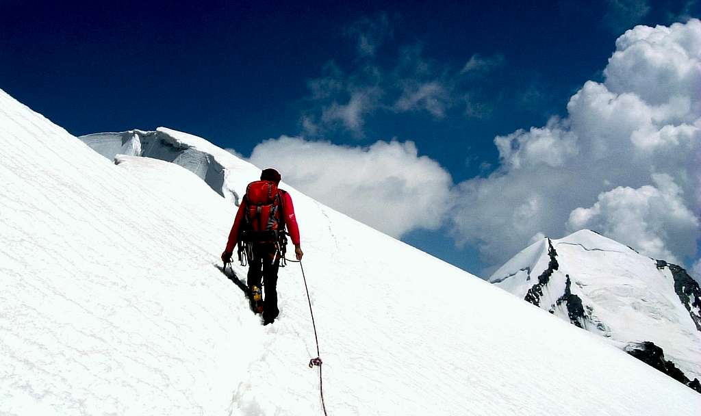
Two different starts: Testa Grigia or Rifugio Mezzalama. The highest Rifugio Guide d'Ayas is located 400 meters above Rif. Mezzalama. The itineraries joins at the base of the SW slope of Roccia Nera. It's an ascent on a glacier, with a first easy stretch (from Testa Grigia to Colle Breithorn) following at first some ski slopes, then a downhill section and one flat, with some crevasses, and finally a steep snowy or icy ramp with a slope up to 40° to the summit.


Route report from Testa Grigia
From Rifugio Guide del Cervino m. 3480, near the upper station of Testa Grigia cable-car, walk along the Plateau Rosà, at first crossing and following some ski-slopes, then crossing the vaste Breithorn plateau up to the Breithorn Col 3831 m, situated between Gobba di Rollin and Western Breithorn.
Leave on the left the track leading to the Western Breithorn and continue slightly descending about 100 meters in altitude across the Verra Glacier upper slopes in the direction of Roccia Nera, then proceed level hillside (beware some crevasses on this section). Ignore any track that climbs steeply to the left towards the Eastern Breithorn, continuing on the right, without losing further altitude and ignoring also the track that descends to the Rifugio Guide Ayas.
Continue straight then to the right, with a semicircle that reports back to the left (other possible crevasses), getting the base of the South-West slope of Roccia Nera.


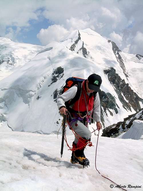
Climb directly up the steep snowy slope (up to 40°), exiting on the summit ridge. Rightwards, a few meters below the wire (attention to possible frames facing North), reach the summit, consisting of a horizontal snow-ridge.
Route report from Rifugio Mezzalama


From Rifugio Mezzalama 3004 m. follow up the side of the moraine in view of the upper Refuge Guide Val d'Ayas just on the spur of Lambronecca Rocks and our ascent trajectory is on the right side. The path becomes not so obvious, but still well marked (yellow), leading to reach the Verra Glacier. Cross its lower section to the right and go up the steep scree, equipped in the last meters, getting to the Rifugio Guide Val d'Ayas. Here take the glacier following a crevassed ramp above towards Castore western wall, then to the foot of Pollux southern ridge, at about 3800 meters above sea level. Here turn to left (west), losing altitude in sight of the vast hill of Porta Nera or Schwarztor, which separates Polluce from Roccia Nera. Climb the slopes below the bivouac Rossi e Volante and pass the bivouac. Further, after crossing a terrace of smooth rock and snow, the route jins the previous one. Here in fact it begins the wide snowy or icy ramp that culminates on the summit ridge of Roccia Nera. At first less steep, the slope becomes immediately steeper, holding for about 200 meters the 40°.
Descent: reversing the same route
Acces from Zermatt - Switzerland
- Route from Klein Matterhorn
The easiest way to arrive to the Breithorn plateau for the traverse to Roccia Nera is the cable car from Zermatt to Klein Matterhorn. Warning: if your acclimatisation is not good don´t use the cable car for reasons of altitude sickness!
Use first the track of Gobba di Rollin ski lift and follow then the track to W Breithorn up to the Breithorn Col 3831 m. From here same itinerary as the Normal route from Testa Grigia previous described: ignore the track branching off to the left and leading to the Western Breithorn and continue slightly descending about 100 meters in altitude across the Verra Glacier upper slopes in the direction of Roccia Nera.


- Route from Gandegghütte and Rifugio Teodulo
Gandegghütte is situated about 1 hour below Rifugio Teodulo.
From Gandegghütte climb the rock ridge - middle moraine south of the hut and follow the ridge and right-west of it until you reach the Theodulgletscher. Follow Gandegg ski lift track until you arrive below Theodul col. If you start at Rifugio Teodulo go down to Theodul col and traverse onto the Theodulgletscher. Both routes join there.


The route to the Breithorn plateau follows the Theodulgletscher to Testa Grigia, traverses then to the ski runs of Plateau Rosa (Ghiacciaio del Ventina) and traverses northeast on a ski road to Klein Matterhorn.
Go on as described above.
Essential Gear
Rope, helmet, axe and crampons, a couple of quick protections and quickdraws, a couple of rings of rope
Red Tape
No fees and no permits required
Huts and Bivouacs
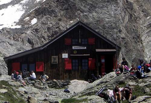
Rifugio Mezzalama 3004 m - Ph. Antonio Giani
Situation: Ghiacciaio di Verra Owner: C.A.I. Torino Open: summer Size: 36 persons Winter shelter: 20 persons Phone:0039-0125-307226
From Champoluc, fraction St. Jacques, reach Blanchard hamlet and then take the path CAI n. 7. After a small bridge, the trail leads through the woods, passes a clearing in the woods and into the wood again until converging with the dirt road (closed to vehicles) coming from Saint-Jacques. Cross the Pian di Verra Inferiore, after which the signposts indicate the Blue Lake and on the right Rifugio Mezzalama and Rifugio Guide Val d'Ayas. After crossing the bridge, we follow the path which cuts the curves of the road then along the river we enter a valley that leads to the Upper Pian di Verra. Shortly before, indicated by two signs, the trail branches off to the left and up the steep slope that forms the other side of the moraine of the glacier. The trail passes along the edge of the moraine in sight of Refuge Mezzalama, then it appears also the higher Rifugio Guide Val d'Ayas. Yet following the moraine reach the Refuge Ottorino Mezzalama 3004 m.
Rifugio Guide d'Ayas 3420 m - ph. Corvus
Situation: Lambronecca Guardian: Guide di Champoluc e Val d'Ayas Open: from July to September Size: 85 persons Winter shelter: 16 persons Phone: 0039-346441219
Bivacco Rossi-Volante - ph. as
Bivacco Rossi e Volante 3750 m
Situation: Verra Glacier near Porta Nera Opening: permanent Owner: Club Alpino Italiano Sez. Torino Size: 10 persons
Access: From the Rifugio Guide Valle d'Ayas to Lambronecca with about 1.30-2 hours on the glacier (difficulty F)- required rope, ice ax and crampons
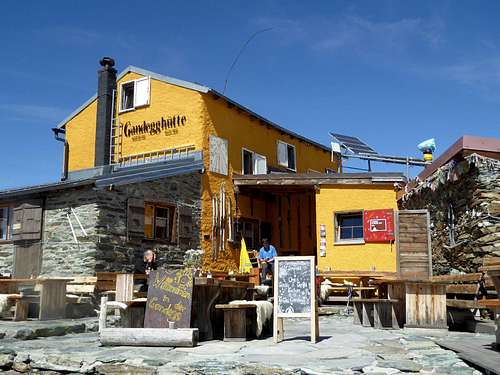
Gandegg hut - ph. selinunte01
Situation: below Theodulgletscher Owner: private: Richi & Yvette Lehner-Gaudin Open: all year round Size: 45 persons Winter shelter: hut is open in winter Phone:0041-(0)79-607 88 68
Access: From Zermatt railway station follow Bahnhofstraße and Oberdorfstraße to the cable car station Zermatt – Furi. Stay right and follow the trail, direction Zmutt (signposts for Gandegghütte) until you can cross the Zmutt creek on a foot bridge left of that trail (again signposts Gandegghütte). Ascend to the Alp village “Zum See” and to “Hermetji". After Hermetji inn a trail branches off to the left in the direction to Furgg. Cross the ski run below Furgg and follow the trail, marked again Gandegghütte. Beautiful view of Matterhorn. The trail climbs the moderate grade slopes up to cable car station Trockener Steg. At a trail junction go straight on (to the right you will reach Trockener Steg), pass by a small lake and arrive at Gandegghütte.
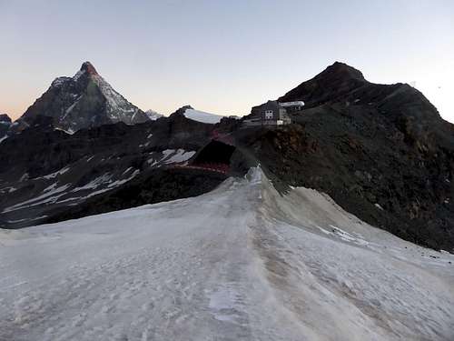
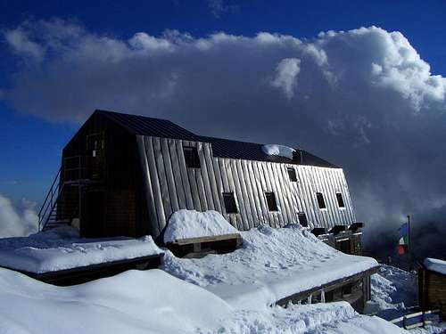
Rifugio Teodulo and Matterhorn
Situation: above Theodulgletscher and Theoduljoch just some meters on Italian ground; 45°56′39″N 7°42′30″E Valtournenche Valle d'Aosta Owner: CAI sezione di Torino Open: all year round Size: 86 persons Winter shelter: hut is open in winter Phone: 0039-0166-949400
Rifugio Teodulo is situated about 1 hour above Gandegghütte. If you approach the Rifugio from the swiss side follow the route to Gandegghütte. Climb the rock ridge / middle moraine south of Gandegghütte and follow the ridge and right / west of it until you reach the Theodulgletscher. Follow Gandegg ski lift track until you arrive below Theodul col. Go right and ascend steeply to the col. Some more steps bring you up to Rifugio Teodulo.
The approach from the italian side starts at Breuil-Cervinia and uses the cable cars os the trails and mountain roads via Plan Maison to Colle Teodulo and the mountain hut.
When to climb

The best period to climb Roccia Nera goes from middle June to the end of September
Meteo
Guidebooks and maps


 Guidebook")

"Il grande libro dei 4000" by Marco Romelli, Valentino Cividini - Idea Montagna Editore, 2015
“Tutti i 4000” – L’aria sottile dell’alta quota” – CLUB 4000 CAI TORINO – Vivalda Editori
“The 4000 of the Alps” by Richard Goedeke (CAAI) – All the normal routes to the 4000m. summits of the Alps – Libris Edition
"Monte Rosa" Gino Buscaini - Guida dei Monti d'Italia CAI-TCI
Maps: IGC n. 5 Cervino e Monte Rosa 1:50000, IGC n. 108 Cervino, Cervinia, Champoluc 1:25000