
-
 20812 Hits
-
 83.55% Score
-
 17 Votes
|
|
Mountain/Rock |
|---|---|
|
|
32.34523°N / 111.15032°W |
|
|
Pima |
|
|
Hiking, Scrambling |
|
|
Spring, Fall, Winter |
|
|
3563 ft / 1086 m |
|
|
Overview
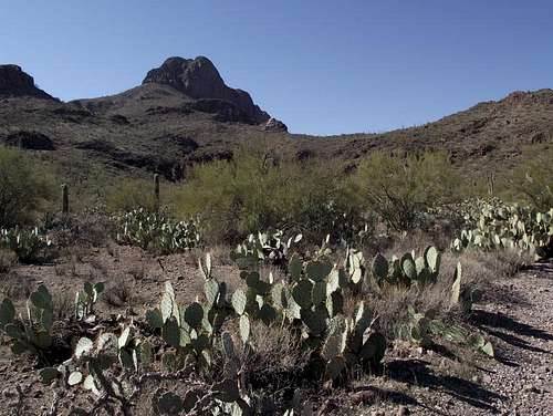 Safford Peak from desert floor
 Saguaro reaching into blue desert sky
Officially designated Safford Peak, this is a surprisingly fun little suburban peak in the Tucson Mountains northwest of Tucson, Arizona. Known more commonly by locals by its nickname “Sombrero Peak” due to its shape, Safford is a fairly popular local hike. “Sombrero Peak” is located in northwest Tucson at the far northern reaches of Saguaro National Park. Safford is a fun, rugged little desert peak that offers fantastic views of the Tucson metro area as well as surrounding ranges including the Rincons, Santa Ritas and Santa Catalinas. The mountain is covered in stunning Sonoran Desert plant life, dominated by thick groves of the noble saguaro. Also present are several cholla, including Teddy Bear and Cane Chollas. Ocatillo are present and if the hiker is lucky enough to see them after precipitation, their flame-red blooms will delight. A variety of birds flit about the desert scrub, and the visitor can expect rattlers lurking around in the rocks. But most notable is a peculiar little inhabitant – the Ringtail. The ringtail, a cousin of the raccoon and coatimundi, is the official mammal of Arizona and a natural rock climber. These animals are omnivorous and primarily nocturnal. While they tend to prefer being closer to water than the summit of a desert peak would permit, their flexible diet enables one little Ringtail (pictured on this page) to claim the summit as his/her personal hangout. Arizona Rank: 4558th highest peak Prominence: 1073 feet USGS Quad: Avra Recreational Map: Trails Illustrated #237 Saguaro National Park Rank & Prominence: Lists of John
| Shy Ringtail | Eye Contact! | Coy Ringtail |
 |  |  |
Getting There

 Safford Peak Summit
There are two primary options for approaching Safford Peak. Sanctuary Cove from the East • From this access, a rough, unmaintained trail reaches the summit. • Access is granted through Sanctuary Cove private land through Arizona State Trust lands and finally into Saguaro National Park land. Directly through Saguaro National Park from the South • This access would utilize either the Roadrunner Trail or the Panther Wash Trail to a bushwhack to gain the saddle between Panther Peak and Sanford Peak.
Red Tape
 Southward from the eastern slopes
 Rules and Regulations
Sanctuary Cove
Rules and Regulations
Sanctuary Cove
 No Dogs in Sanctuary Cove
If approaching from the south, please respect Saguaro National Park user regulations. In particular no dogs are allowed, leashed or otherwise, on trails (besides a few designated interpretive trails) within the park. If approaching the peak from the east, be familiar with use regulations for Saguaro National Park and Arizona State Trust lands. Note that access to the State Trust parcel encompassing the east slopes of Stafford Peak does not seem to be limited in any way. Please be especially respectful of the user regulations outlined by Sanctuary Cove. Appreciate that these private landowners share their property with the Tucson community and disobeying their very reasonable regulations could jeopardize access for all of us. In particular, do not litter, do not rock climb, do not park overnight in their parking area, and leave your dogs, alcohol or drugs at home. For more information, visit the following websites: • Sanctuary Cove Website • Saguaro National Park Website
Camping & Lodging
 Saguaro grove
 Mount Lemmon through Saguaro
Note that there is no car camping available in the western district of Saguaro National Park. Likewise, there is no camping available and no overnight parking allowed in Sanctuary Cove. The primary area campground is the 130-site Gilbert Ray Campground, located in Tucson Mountain Park. The proximity of the Tucson Metro to the Tucson Mountains area means lodging options are virtually unlimited. Visit the Trip Advisor site covering Tucson, AZ, for more information about area accommodations.
Weather & Seasons
| *Most hikes in the Tucson Mountains, thanks to their low elevation, would be most comfortable in the fall, winter or spring. *March and April are primo wildflower viewing months. *Summer temperatures in this part of the Sonoran desert can be worse than uncomfortable; they can be downright dangerous! *According to the United States National Weather Service, the record high temperature for Tucson, Arizona, set on 26th June 1990, was 117 degrees Farenheit / 47 degrees Celsius. |

bamboola - Jan 22, 2016 10:52 am - Hasn't voted
Update on trail conditionsSombrero Peak route Jan 2016 From the Sanctuary Cove parking, which is clearly marked, walk west on the main path past the labyrinth. Follow this rock-lined path up the slope to the west and continue as it turns north. After this very distinct path drops in elevation start watching for a fainter trail heading west again. This trail has plenty of cairns. It will intersect with a very distinct north south trail. Follow this south until you pass a great view of Sombrero Peak’s impressive north facing wall (and wonder if it is really possible to get to the top.) Continuing south you will encounter a saddle where there is a distinct trail toward the peak. This trail climbs steeply but without much trouble of losing the way, and without many switchbacks, all the way to the cliffs on the east side of the peak. The trail takes you to the south and wraps around the base of the cliffs to a break in the cliffs on the south side of the peak. Follow the even steeper path to the summit. There is a short and heart rate increasing rock bridge near the very end. I crossed it on hands and knees, but it does not require protection. The peak is reachable in about 2 hours, with breathers. The key on returning is to remember to stay close to the cliff base, as there are false trails that will take you down too early. My partner had a ‘breadcrumb’ tracking GPS program on his phone that warned us if the return path deviated from the ascent, which was easier to follow. Overall the trail is much more distinct now than the few descriptions several years back. This climb is a real gem.
Sarah Simon - Feb 9, 2016 2:58 pm - Hasn't voted
Re: Update on trail conditionsWhy don't you read the route page: http://www.summitpost.org/sanctuary-cove/702113 Then see if anything needs an update. Happy to help. Cheers, Sarah