
-
 142203 Hits
-
 99.85% Score
-
 147 Votes
|
|
Area/Range |
|---|---|
|
|
37.68000°N / 107.392°W |
|
|
Hiking, Mountaineering, Trad Climbing, Sport Climbing, Toprope, Ice Climbing, Aid Climbing, Big Wall, Skiing |
|
|
Spring, Summer, Fall, Winter |
|
|
14309 ft / 4361 m |
|
|
Overview
The San Juans are undoubtedly Colorado's finest range with unsurpassed beauty and enough peaks, lakes and open meadows to feed your mountain climbing, backpacking and photography desires. In fact, the San Juans are the best place in Colorado to embark on long treks involving many consecutive days of cross country travel. There are 12 of Colorado's 53 ranked 14ers in the San Juans with an additional two, El Diente and North Eolus that often make climbers' lists due to their beauty and overall difficulty to ascend despite not quite having 300 feet of prominence. The highest peak in the San Juans goes to Uncompahgre Peak at 14,309 feet in elevation. One striking feature about this mountain is that it is massive! While many San Juan peaks have steep slopes and cliffs leading to tiny summits, Uncompahgre has very broad slopes leading up to a giant summit area that's large enough to house an army. This was a true surprise when I climbed it and gave the mountain a unique feeling...highly recommended. Although there are 14 beautiful 14ers in the range, it is the 13ers that make the San Juans so special. With 314 rugged peaks between 13,000 and 13,999 feet the San Juans include an astonishing 43 percent of all the 13ers in the state. The only three centennial 13ers in Colorado that require class 5 traveling are found in the San Juans and offer a monumental capstone trio for many Colorado climbers working towards the Centennials. In total there are sixteen centennial 13ers in the San Juans, added on to the twelve 14ers, to provide you an incredible list of peaks to climb! The San Juans are remote, rugged and wild.
 Storm King Peak
 Potosi Peak
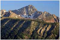 Wilson Peak
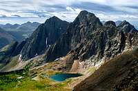
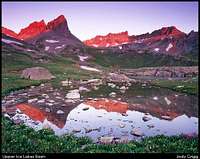 Ice Lakes Basin
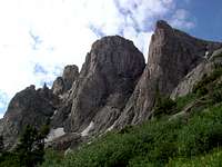 Turret Peak
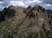 Animas Mountain
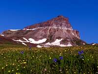 Uncompahgre Peak
 Vermilion Peak
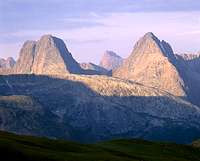
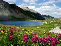
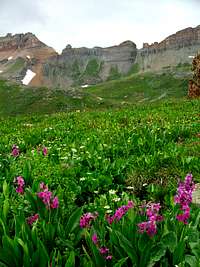 Wildflowers at Ice Lakes
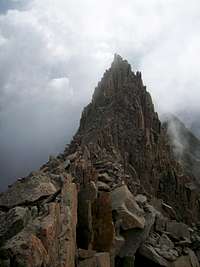 El Diente/Mount Wilson Traverse
| Mountain | Elev (ft) | Prom (ft) | Easiest Route | Colorado Rank (300P) |
|---|---|---|---|---|
| Uncompahgre Peak | 14,309 | 4,242 | East Slopes - Class 2 | 6 |
| Mount Wilson | 14,246 | 4,024 | North Slopes - Class 4 | 16 |
| El Diente Peak | 14,159 | 259 | South Slopes - Class 3 | Unranked |
| Mount Sneffels | 14,150 | 3,050 | Lavender Couloir - Class 2+ | 27 |
| Mount Eolus | 14,083 | 2,183 | Northeast Ridge - Class 3 | 32 |
| Windom Peak | 14,082 | 1,022 | West Ridge - Class 2+ | 33 |
| Sunlight Peak | 14,059 | 399 | South Slopes - Class 4 | 39 |
| Handies Peak | 14,048 | 1,908 | West Slopes - Class 2 | 40 |
| North Eolus | 14,039 | 179 | From Mount Eolus - Class 3 | Unranked |
| Redcloud Peak | 14,034 | 1,436 | Northeast Ridge - Class 2 | 46 |
| Wilson Peak | 14,017 | 877 | West Ridge - Class 3 | 48 |
| Wetterhorn Peak | 14,015 | 1,635 | Southeast Ridge - Class 3 | 49 |
| San Luis Peak | 14,014 | 3,114 | East Slopes - Class 1 | 50 |
| Sunshine Peak | 14,001 | 501 | From Redcloud Peak - Class 2 | 53 |
| Stewart Peak | 13,983 | 883 | North Slopes - Class 1 | 55 |
| Pigeon Peak | 13,972 | 1,152 | Southwest Slopes - Class 3+ | 57 |
| Gladstone Peak | 13,913 | 733 | North Ridge - Class 3 | 67 |
| Phoenix Peak | 13,895 | 1,515 | South Slopes - Class 1 | 73 |
| Vermilion Peak | 13,894 | 2,105 | Southeast Ridge - Class 2+ | 74 |
| Vestal Peak | 13,864 | 1,124 | South Slopes - Class 2+ | 77 |
| Jones Mountain | 13,860 | 520 | South Ridge - Class 2 | 78 |
| Half Peak | 13,841 | 1,501 | South Ridge - Class 2 | 86 |
| Turret Peak | 13,835 | 735 | Northwest Slopes - Class 2+ | 89 |
| Point 13,832 | 13,832 | 812 | Northwest Ridge - Class 2 | 90 |
| Jupiter Mountain | 13,830 | 370 | Southwest Slopes - Class 2+ | 92 |
| Jagged Mountain | 13,824 | 964 | North Face - Class 5.1 | 94 |
| Rio Grande Pyramid | 13,821 | 1,881 | East Slopes - Class 2 | 97 |
| Teakettle Mountain | 13,819 | 759 | Southeast Ridge - Class 5.3 | 98 |
| Point 13,811 | 13,811 | 551 | South Slopes - Class 1 | 99 |
| Dallas Peak | 13,809 | 869 | East Face - Class 5.3 | 100 |
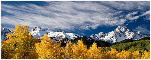 Mount Sneffels in the fall - Photo by Yorksman
The San Juans are divided into seven wilderness areas, including Colorado's largest, the Weminuche Wilderness which is also among the list of favorite places for many Colorado climbers. Shown below is a summary of the wilderness areas within the San Juans.
| Wilderness | Photo | Brief Description |
|---|---|---|
| Weminuche Wilderness |
 |
Spanning from the Animas River to the town of South Fork, this is Colorado's largest wilderness capped my Mount Eolus and home to 492,418 acres of wild and unspoiled mountains. The Needle and Grenadier mountains dominate the wilderness and offer some of the best mountaineering in the state. |
| South San Juan Wilderness |
 |
Located to the east of Pagosa Springs, the South San Juan Wilderness is the only place left in Colorado that might still hold a small grizzly bear population. The area is so rarely traveled yet home to 158,790 acres of wild and volcaniclastic mountains. All the rocks seen here are the remnants of 20,000 foot volcanoes that existed millions of years ago. Today, the wilderness is capped by 13,300 foot Summit Mountain. |
| Mount Sneffels Wilderness |
|
This small, but insanely rugged wilderness capped by the namesake mountain also holds the two hardest centennial 13ers in Colorado. Like the S. San Juan area, these mountains are the remnants of ancient super-volcanoes and are young in geologic age. This area is known for the classic calender photos of Mount Sneffels particularly in the fall when masses of aspen trees glow bright yellow and orange. |
| La Garita Wilderness |
 |
Meaning "The Lookout" in Spanish, this wilderness is one of Colorado's original five and hosts 128,858 acres of land in the far eastern parts of the range. The highest peak is San Luis but nearby are two high 13ers. Rocks here are also volcanic in origin and areas like the Wheeler Geologic Area show very well how wind and water can play a role in the deposition of volcanic material during an active eruption. |
| Uncompahgre Wilderness |
 |
This 102,721 acre wilderness, home to the highest peak in the range, is slightly gentler than other areas in the San Juans for general cross country travel. Despite this, peaks like the Wetterhorn and the Coxcomb are found here and give this area a more friendlier ruggedness feel which generally draws more people. This area spans the northernmost part of the range and largely accessed from Lake City. |
| Lizard Head Wilderness |
 |
Not intended for climbers uncomfortable with exposure, the Wilson group calls this wilderness home. These mountains are different than most in the San Juans in that they are a large igneous intrusive body of granite that failed to reach the paleo-surface and have since been exposed by erosion. The Lizard Head is Colorado's most technical ranked 13er and calls the name of the heartiest of climbers. In the recent past private property issues in the northern part of the wilderness have proved problematic for access to the Wilsons from the north but a resolution has now been put into place and the Rock of Ages TH is now open once again! |
| Powderhorn Wilderness |
 |
This smaller wilderness area lies just to the NW of the La Garita Wilderness and is surrounded with the same volcanic type of rocks like the Fish Canyon Tuff. Due to the nature of the erosion process of tuff, like the La Garita Wilderness, the area is topographically gentle however flocked with lots of wildlife. No area in this wilderness exceeds 13,000 feet making it scarcely visited. |
Overview Map
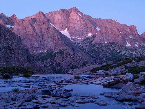 Dawn on Mount Eolus - Photo by Jack B
Getting There
 San Luis Peak from the Colorado Trail
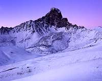 Dawn on Wetterhorn Peak - Photo by Jack B
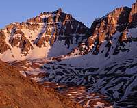 Sunset light on the Teakettle
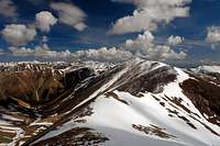 Summit view from Redcloud Peak
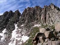 North Face of Jagged Mountain
 Near Jones Mountain
Access into the San Juans highly depends on which area you're pursuing and what time of year you go. There are many trailheads around the entire periphery of the range and many have the option for high clearance four wheel drive vehicles that in some places can take you well above treeline in the summertime. Described below are directions to the major trailheads that I believe provide the best summer access for many of the Centennial 13ers in the San Juans. Keep in mind it takes for ever to drive around this range. You cannot very easily climb all the high San Juan peaks without a good plan. The towns of Gunnison, Lake City, Creede, Pagosa Springs, Durango, Silverton, Telluride, Ouray, and Ridgeway are all San Juan mountain towns. They are also all a considerable distance apart from one another and I would recommend circling the range one time if you want to get them all in one trip.
La Garita Wilderness: Access to San Luis, Organ and Stewart Peaks Stewart Creek TH - Gunnison
From Highway 50 near Gunnison head south for 20 miles on CO 114 and turn right onto the Old Agency Road (FS 3083). Follow Cochetopa Creek for 3.5 miles and turn right onto FS 3084 which will turn into FS 788. After 8.8 miles on this road bear left onto FS 790 and follow this for 10 more miles. Turn left onto FS 794.28 (also Perfecto Creek Road) and continue 4 miles crossing two creeks and then make a right on FS 794. Continue 4.5 miles to the trailhead where you will have just driven 30 miles on dirt roads! This trailhead is very inaccessible in the winter as are the peaks in the La Garita Wilderness. Another trailhead with an equally long drive on dirt roads is the West Willow Creek (Equity Mine) Trailhead accessed from the town of Creede.
Uncompahgre Wilderness: Access to Uncompahgre and Wetterhorn Matterhorn Creek TH - Lake City
From Highway 50, head south on CO 149 for 45 miles to Lake City. From the Second Street and Gunnison Avenue (CO 149) near the center of town, head west on 2nd Street for two blocks at the roads' end and turn left on Bluff Street. Continue on this road, which quickly turns into Henson Creek Road. After 5 miles pass the Nellie Creek Road turnoff and after 9.2 miles on this road arrive at the North Henson Creek Road at the town-site of Capitol City. Turn onto the North Henson Creek Road (FS 870) and head 2 more miles to where the road gets much rougher. 4WD vehiches can proceed to the wilderness gate half a mile further. Camping can be found here. The Nellie Creek TH, useful for just a climb of Uncompahgre can be accessed by turning onto the Nellie Creek road mentioned above.
Mount Sneffels Wilderness: Access to Sneffels, Teakettle and Dallas Yankee Boy Basin TH - Ouray
From Ouray, head a half mile south on 550 and turn south on CR 361. This road climbs steeply so beware! After 5 miles stay right and continue on what I think is the most bazaar road ever. It's carved out of an overhanging cliff! After about another mile on this road continue straight and park cars at mile 6.7 at 10,700 feet elevation. Four wheel drive can go another 1.3 miles to around treeline where there is a small pit toilet and lots of jeeps that tend to hang around.
Handies Group TH: Access to Handies, Redcloud, Sunshine, Point 13,832, Point 13,811 and Half Peak Silver Creek-Grizzly Gulch TH - Lake City
From Lake City, head south on CO 149 for 2 miles and turn right on the Lake San Cristobal Road and continue 13.1 miles to the Mill Creek Campground. As a fun fact, Lake San Cristobal is the largest natural lake in Colorado! About a mile past the campground, turn right onto the Cinnamon Pass Road and follow the shelf road for an additional 4 miles to the TH. There is lots of camping here and a well kept outhouse. Passenger cars must stop here. 4WD vehicles can continue another 3.5 miles to the American Basin TH for a shorter route on Handies. For Half Peak, instead of turning right on the Cinnamon Pass Road, continue left for 1.2 miles to the Cataract Gulch TH.
Weminuche Wilderness: Access to the Needle and Grenadier Ranges Refer to the next section for detailed info about the Weminuche
Lizard Head Wilderness: Access to the Wilson Group and Gladstone Rock of Ages TH - Telluride
This TH provides feasible access to all these peaks and has recently been re-opened thanks to the hard work that led to the building of a very windy but legal trail around the private property in the area north of the Wilson group. From the junction of CO 145 and CO 62 near the small town of Placerville, head 6.7 miles east on CO 145 and turn south on the Silver Pick Road. Bear left at 3.3 miles and take the middle fork 0.75 mile further. About 2.3 miles after taking the middle fork, enter the Uncompahgre National Forest after traveling 6.3 miles on this road. Stay left a tenth of a mile further and reach the TH after 7.2 miles from the highway. Good camping can be found here and a windy trail leads southwards to the Rock of Ages Saddle where you can then drop into Navajo Basin. Other trailheads include the Navajo Lake TH and Kilpacker Basin TH on the southwest side of the Wilson group but these have much longer approach hikes.
Jones Group TH: Access to Jones Mountain, American and Niagara Peaks Grouse-Burns Gulch TH - Silverton
This TH will allow one to climb all three peaks in one simple day. From Silverton drive 4 miles on CO 110 to Howardsville and pass the ghost town of Eureka after 8 miles. Start climbing steeply just past Eureks for three miles to the TH where a 4WD road crosses the Animas River to the right. This is the start of the route and the TH. 4WD can continue 1.8 miles into Burns Gulch after fording the river.
South Mineral Creek TH: Access to Vermilion Peak and Ice Lakes Basin
Ice Lakes Basin is a special place tucked away close to Silverton. Lone Centennial Vermilion Peak is accessed from here. From Silverton head 2 miles west on Highway 550 towards Ouray and turn left on South Mineral Creek Road. Continue up this good road and stay left after 3.7 miles and reach the TH after 4.4 miles. Most vehicles can also head right at mile 3.7 and climb steeply for 1 mile to a sharp switchback and park. There is room for only a few cars here but this option knocks 500 feet off your approach. Just pass by a nice waterfall and meet up with the main trail up Ice Lakes Basin.
 |
The Weminuche Wilderness
Approaches into the Weminuche
 The Grenadiers
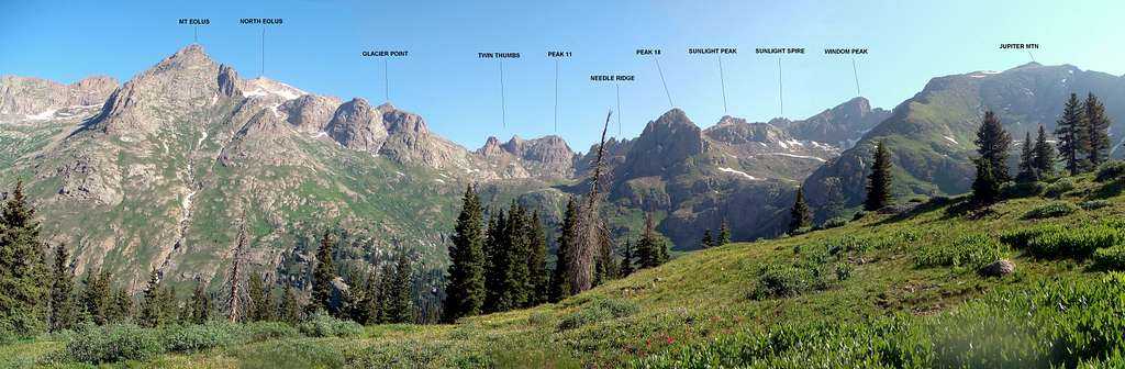
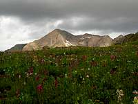 Mount Eolus
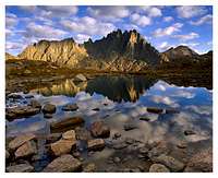 Jagged Mountain in the heart of the Weminuche
Elk Park/Needleton Trailheads
Six miles south of Silverton down the Animas River at 8,860 feet is the Elk Park Trailhead. One can fairly easily walk to this trailhead either from Molas Pass or from the town itself. If you decide to park at Molas Pass and hike the Colorado Trail down to Elk Park, the trail is very scenic indeed but loses 1,800 feet of elevation over a one way distance of 3.5 miles. It is likely you will have to re-gain this at the end of your trek. For those less monetarily challenged the standard way to reach Elk Park is by the Silverton-Durango Narrow Gauge Railroad. Schedules for the train varies by season and time of day. This ride is said to be something everyone from Colorado must do before they die. I highly recommend it as an approach into the Weminuche. The typical summer schedule to ride the train is described below:
Note: This is the updated schedule for the 2015 summer season
| Dates | Train Departs Durango | Train Arrives Silverton | Train Departs Silverton | Train Arrives Durango |
| May 2nd - October 31st | 8:45 am | 12:15 pm | 2:30 pm | 6:00 pm |
| May 18th - October 15th | 8:00 & 8:45 am | 11:30 & 12:15 pm | 1:45 & 2:30 pm | 5:15 & 6:00 pm |
| June 8th - August 6th | 8:00, 8:45 & 9:30 am | 11:30, 12:15 & 1:00 pm | 1:45, 2:30 & 3:00 pm | 5:15, 6:00 & 6:30 pm |
See This site for more information about scheduling and rates for the train. As you can see, if you plan to take the train into Elk Park, you will be getting a late start your first day. This is the one crucial disadvantage to taking the train because they never leave Silverton in the morning. You could however take the train in from Durango to start earlier but the train ride is much longer and considerably more expensive. It's also important to note that there are three (3) trains that run. In the peak of the summer season, they all run as seen in the schedule. As of summer 2011, be aware that NONE of the trains stop at both Elk Park and Needleton. It is not possible to get on a train at Elk Park and get off at Needleton, or vice versa. If you get on a train, you are bound for either Silverton or Durango, depending on the direction of travel. All the trains start in Durango in the morning, leave Silverton in early afternoon and arriving back at Durango in the evening while stopping at either Elk Park or Needleton. There are four different classes each increasing in price. The standard class, which I think is the best is cheapest. It has open air cabins and usually costs about $83. The cost only increases as you upgrade to the Deluxe, First or Presidential classes. Not needed for us backpackers!
 Riding the train
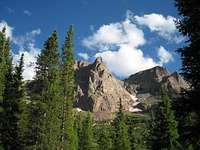 Sunlight Peak from Chicago Basin
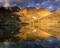 Windom and Sunlight Peaks
From Elk Park, the Colorado Trail continues east following Elk Creek. To reach the Vestal Group and beyond, you will find a faint boot path heading south following Vestal Creek from where it dumps into Elk Creek. Following this path can be difficult at times and one must also cross Elk Creek to reach it which can be dangerous or even impossible in early summer after a wet year. The boot path follows Vestal Creek on the east side before reaching Vestal Lake at the base of the Wham Ridge route on Vestal Peak, one of Colorado's premier mountaineering routes. If you are coming from Molas Pass, a nice bridge crosses the Animas River allowing easy access to Elk Park. Heading beyond Vestal Basin you enter Colorado's most remote and rugged mountains. The Needleton trailhead, which is also along the Animas River, is seven miles further south than Elk Park and therefore 600 feet lower. There is an alternative to the train to reach Needleton known as the Purgatory Trailhead. This trailhead is located right off Highway 550 at the Purgatory Campground, 7.7 miles south of the summit of Coal Bank Pass. It's a long walk to Needleton from here! The primary destination for people entering the Weminuche from either the Needleton or Purgatory trailheads is Chicago Basin. Three 14ers and one Centennial 13er ring this beautiful place and is accessed by a gentle 6 mile long trail from Needleton. Mt Eolus, Sunlight Peak and Windom Peak are almost always climbed together from a camp in Chicago Basin. This place is very popular in the summer and it shows. There is no camping allowed at Twin Lakes in upper Chicago Basin and the nice sites further down get taken fast. Get there early! Much fewer people climb Jupiter but it can be a great way to spend another day in this grand place. For the more adventurous, peaks like Jagged Mountain, Pigeon Peak, Animas Mountain, Knife Point and most of the Numbered Needle Peaks can be accessed by heading northwest over the small Twin Thumbs Pass and into the wild and rugged Ruby and Noname drainage basins. This class 2+ climb is only suited for people prepared and in great shape. A great way to escape the crowds of Chicago Basin without testing your limits too much would be to follow the well established Columbine Pass trail to the southeast of the basin. Use this trail initially to climb Jupiter Mountain.
 The Grenadier Range from near Stony Pass
Beartown Trailhead
This trailhead arguably gets you the closest to the heart of the Weminuche than any other, although you will be further away from the bigger peaks on the western margain of the wilderness. Simply getting here could be the most difficult part of a trip and surely be an adventure in and of itself. A high clearance four wheel drive vehicle is required for this long and rough road. From Silverton, drive north out of town on CO 110 and drive along the Animas River on this good dirt road for 4.2 miles. Once you get to Howardsville, turn right onto the Cunningham Creek Road (FS 589) and go 1.7 miles. Head left onto the Stony Pass Road (FS 737). After 4.2 miles on this rough road you will reach the summit of Stony Pass. A commanding view of Rio Grande Pyramid can be seen from here. Start descending the other side and continue 6.5 more miles on what is now the Rio Grande Reservoir Road (FS 520) and finally, turn right onto the Beartown Road. Going 5.6 more miles on this exceedingly rough road, passing one difficult ford of the Rio Grande River and the ghost town of Beartown, gets you to the Beartown Trailhead at last! This trailhead makes a great place as a re-supply station for hikers thru-hiking the Colorado Trail as the section through the San Juans is long and rugged with few places to pick up supplies and food. Climbing the Centennials from here is however a little impractical due to the longer approach required (although it's about the same if you start at the Purgatory Trailhead) and the insanely long jeep ride. This place may be better suited for off road enthusiasts due to the lack of wilderness areas in this part of the range.
Off-Roading
 Looking to Ophir Pass from Lookout Peak
 Stony Pass Peak
 Uncompahgre and Wetterhorn seen from Engineer Pass
 Vestal Peak
Outside the wilderness boundaries surrounding Silverton and Ouray there are numerous jeep roads that are very popular with 4X4 enthusiasts. During the summer, one can drive over Ophir Pass as a short-cut between Telluride and Silverton instead of heading all the way around through Ridgeway and Ouray. This saves at least an hour with a high clearance vehicle and brings you to 11,800 feet with spectacular views. This area is well known for abundant wildflower displays rivaling that of Ice Lakes Basin so take your time here. The town of Ophir is a quaint little place as well. Although passenger cars are able to summit Ophir Pass from the east side only, it isn't recommended. Cinnamon Pass, likely the most popular connects Lake City and Silverton by heading west from Animas Forks. It has a summit elevation of 12,600 feet. Passenger cars can make it all the way to the Silver Creek-Grizzly Gulch TH on the Lake City side and the Burns Gulch TH on the Silverton side. Although it is possible to drive over in a Subaru Forester, don't! His car didn't escape unscathed... Another popular track is Engineer Pass with a summit elevation of 12,800 feet. It branches off to the north from Animas Forks and descends to Ouray. This stretch of Engineer Pass near Ouray is by far the most difficult and will test stock 4WD vehicles. Combining Cinnamon and Engineer passes takes you along the famous Alpine Loop which is a drive than can be done in one day but more time is recommended to enjoy the scenery.
Geology
The San Juan Mountains are different from all other Colorado ranges. It doesn't take too much for someone to see that the general scenery, the colors and the rocks just "appear" different than the rest of Colorado. This is largely due to the distinctly different geology in the San Juans. Most of Colorado's mountains like the Sawatch, Front, and greater Park Ranges were uplifted around 40 million years ago during the height of the Laramide Orogeny (for more information about what was the driving mechanism for the Laramide Orogeny see This page...or This page. This is very advanced geology and beyond the scope of this description).
This massive mountain-building tectonic event is responsible for the majority of what we see today in all of Colorado and Utah. Rocks seen in these ranges are Pre-Cambrian gneiss, schist and some granite. As an example, the Idaho Springs Gneiss comprises most of the I-70 Front Range and most of the Front Range foothills up to the high peaks. Similar rocks are seen in the Sawatch and Tenmile/Mosquito Ranges. These are all very old, hard rocks that are very difficult to erode. Sedimentary rocks that once covered the entire landscape have since been eroded away due to the uplift which elevated land over 2 miles in some places. Remnants of these sedimentary layers are seen at Red Rocks Amphitheater, Dinosaur Ridge, Boulder Flatirons and Garden of the Gods to the east, and the Maroon Bells and Glenwood Canyon in the west. Next time you head up I-70, notice these sandstones that flank the mountains dip to the east; because they have been "pushed" up by the basement rocks below. The Maroon Bells dip slightly to the west for the same reason. The rock that comprises Capitol Peak and Snowmass Mountain is about the same age as the rocks in the front range however these are clean granite which erode to the dramatic knife edge ridges and towers due to the fracture networks.
Now what about those San Jauns? Well, I'll start by saying that all the rocks we see in the other Colorado ranges are also in the San Juans...just below the volcanic rocks we see. Rocks here are extrusive volcanic rocks which means they were all deposited as a result of super-massive volcanic eruptions that occurred between 20 and 25 million years ago, towards the latter stages of the Laramide Orogeny. Believe it or not, there were once 20,000 foot volcanoes in the San Juans that produced the largest eruptions ever seen in Earth's history from what geologists can currently determine. The highest peaks in ALL of the San Juan wilderness areas are remnants of massive caldera volcanoes similar to today's Yellowstone...only bigger and shaped more like today's Mount Rainier. Taking a look at Google Earth zoomed out to an altitude of around 100 miles over the La Garita area in the eastern San Juans, there are clearly identifiable "circles" that span 5-10 miles across. These are the remnants of the old calderas that deposited volcanic rocks during eruptions. The areas with the thickest volcanic rock coverage are the La Garita wilderness where San Luis and Stewart Peaks are. Moving west the volcanic package gets thinner as you are moving further away from the site of the ancient volcanoes. Go west far enough, like the area around Molas Pass and you can then see the rocks below the thick volcanic package. These include the Leadville Limestone (which is seen at the Molas Pass overlook), some shale layers and the famous quartzite (metamorphosed quartz sandstone) that forms the sweeping faces of the Vestal group. This quartzite is the oldest exposed rocks in all of the San Juan area and coincides closely with the age of the rocks in the Sawatch and Front Ranges.
Bringing this a step further, since the quartzite is so old, and there are many rocks sitting above it, there are large unconformable surfaces throughout the San Juans with large amounts of time missing from the rock record, similar to what is seen at Red Rocks where the red colored Fountain Formation lies uncomfortably to the Idaho Springs Formation with about 1.4 billion years of missing time. Keep in mind though that even though the basement rocks that we see in the high mountains are much older than the sedimentary rocks that have since eroded away, the formation of the Rocky mountains and the uplift process happened after the deposition of the sedimentary units, whether atop the area where the Front Range or the San Juans currently sit today. Since extrusive volcanic rocks erode much easier than the gneiss or granite seen in other Colorado Ranges, you have much looser, crappier rock in the San Juans to contend with. There is however also much richer soils that form which is the primary reason for the dramatic display of wildflowers and deep blue colored lakes. Volcanic soils are very rich in nutrients and minerals for plants. The quartzite is the only refuge from the crumbly volcanic rocks in the area and it is cool to note that quartzite is the hardest rock on earth. As for how the sweeping faces got to the way they did somehow sitting on top of the much younger volcanic rocks is a mystery to many geologists since the entire area has been extended and normal faults are found everywhere in the area. The only exception to the extrusive volcanic geology in the San Juans are the Wilson Group. These mountains are intrusive volcanic rocks similar to the La Sal Mountains just to the west. To make a long story short, they are different and generally have better rock quality however they are still heavily fractured. I hope I didn't confuse anyone, I am a geologist myself and I often try to teach basic geologic principles to all my climbing partners so I hope you found this useful!
Climate
 Indian Paintbrush at Ice Lakes Basin
 Matterhorn from the slopes of Uncompahgre
 Uncompahgre Peak
The San Juans are known to have the most amount of snow just about every winter in Colorado. The Wolf Creek ski area boasts being the snowiest place in Colorado with 465 inches each year. Many alpine areas, especially north facing slopes may not ever melt out each year although by July the majority of the winters' snow has melted and the alpine flowers and lush greenery comes out for 1-2 months during the summer. The volcanic nature of much of the San Juans provide very rich soils for healthy wildflowers, grasses and bushes, aided by how wet they are compared to many other parts of Colorado. The first snows usually fall in mid-September and stick around on north facing slopes. By late October much of the high mountains have a good "first coat" of snow usually requiring the need for traction and axes for safe travel. By December, winter is in Full force and snowshoes/skis will likely be a must through mid-April on a normal year. 2011 however was an anomaly. There was still feet of snow in the San Juans at the end of June.
Below is a generic season by season climate summary
December-Mid April: This is the full winter season. It is just about always very windy, snowing about every other day and below freezing the entire time. Be prepared to have every inch of skin covered and have snowshoes/skis and winter mountaineering gear at all times. Knowledge of avalanche conditions and safety is required, as well as proper gear. Nighttime temperatures can easily dip below -20 degrees F.
Mid April-Mid June Springtime! The weather begins warming up and the snows consolidate. This is a time of great change. Although the nights are still below freezing, the daytime temperatures can reach 60 above treeline. This is prime couloir climbing season. Climbs like the Lavender Colouir on Sneffels, the SW couloirs on Uncompahgre, the Vermilion Dollar Colouir and the American Peak Couloirs become fantastic climbs with proper gear. This would include cramp-ons, axe, good boots and self-arrest skills. Backpacking season is just around the corner.
Mid June-Mid September: Summer has arrived. Nights can be chilly but the days can also be pretty warm. Thunderstorms become the primary danger above treeline. Get off ridges and summits by noon everyday, unless it's a perfect bluebird day. Always watch the clouds as they grow fast! Unexpected snowfields that persist can also turn around the unprepared. Consider carrying at least an axe for tougher climbs.
Mid September-November: This is the time where the aspens change color and display what Colorado is so famous for. September is often thought of as the best month in Colorado. The thunderstorms decrease yet it is still pleasant and beautiful. Climbing is a must during September. Later on, snow begins to fall and doesn't completely go away. The first big storm, usually around the middle of October ends hiking season but the hearty still head out for winter mountaineering.
Red Tape
For the most part, most of the San Juans are free for any sort of red tape. All the wilderness areas do not require fees to enter, none of the roads charge tolls and the entire range is open to camping with the exception of private property and the upper Chicago Basin. It is quite amazing actually that Coloradan's have this luxury despite many areas being so popular. My friends in WA are forced to pay to park at ANY trailhead and often must pay for permits to enter many areas in the high Cascades. Currently, the San Juans do not have this hindrance and it is up to us to keep it that way. Practice Leave No Trace techniques, respect the land and have fun! Please respect the forest service wishes and do not camp around Twin Lakes in Chicago Basin. They do occasionally patrol this area. Also of note, the mountain goats here would be considered the Einstein (or Newton) for their species. They can get into anything they wish and will approach you with no fear for your food or pee. Keep your food with you or WELL secured. Do not pee on the wildflowers or grasses. The goats will flock you, chase you away and devour anything with your pee on it! If you ask me, these goats are terrible and are in some ways worse than people to the pristine mountain ecosystem.
Other External Links
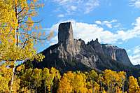 Chimney Rock
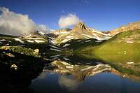 Ice Lake reflection
Gerry Roach has two fantastic books about Colorado's high 13ers and 14ers.
Kiefer - Jul 20, 2022 6:24 am - Voted 10/10
HistoryJust thought I'd share a tidbit I came across while researching a page of my own in some old annuals. In the Northern San Juan's, Molas Pass was named by the early Spanish Missionaries (1700's) who while traversing the pass, witnessed "many moles & voles" on the ground near present-day, Molas Lake. Molas is old Spanish for mole.