A late September trip to the desert
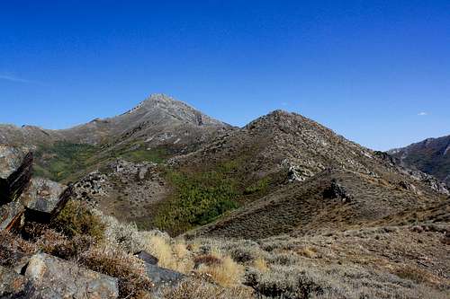
![West Ridge]() Santa Rosa Peak
Santa Rosa Peak
The Oregon Nevada border area has been one of my favorite places to explore. Generally I find myself hiking in the high desert in the late winter or spring once its cooled down and the mountains still have some snow. Troy and myself had been talking about doing a trip down here sometime late in the year, however I impatiently proposed moving the trip up to late September instead since neither of us had more pressing plans and the weekend was free.
I met Troy in Pendleton around 6pm and we set out for Lakeview. We managed to drive until sometime around midnight which put us just outside Lakeview, a distance of around 300 miles in around 6 hours, doesn't sound real impressive until you experience Highway 395 in the dark! We camped for the night at Chandler State Park for a few hours before getting a predawn start. Lakeview is one of the last reliable places to find gas before setting out for Denio, so the Shell station on the north end of town was a quick stop for gas and hot case burritos.
Our first day out included summits of Beatys Butte via the north ridge 4x4 road, and BM Stevenson via Little Pinky Reservoir. These were repeats for me and first ascents for Troy who is nearing completion on the Oregon Top 100 list. Perhaps the most challenging part of this day was the huge amount of driving, going from Lakeview to Denio via highway 140 and the Whitehorse Ranch Road.
After all this driving and a 10 mile peakbag of Stevenson BM we made camp in the dark around 8pm. The next day we crossed the Quinn River Valley to the Santa Rosa Range for an attempt of the ranges namesake peak.
West Ridge Route
Troy B and I climbed Santa Rosa Peak utilizing the west ridge based on a route detailed by
Dennis Poulin . Essentially we drove a 4x4 road up the west ridge from Antelope Creek on the west side of the range. This started us out at 6000 feet rather than in the bottom of one of the canyons as I believe is common practice for people attempting this peak. I was able to make this drive with my little 4 door Suzuki Sidekick with average clearance. The road climbs to 6200 feet or so, but there is a decent spot to park at 6000 feet, and there were some large rocks across the road I didn't want to risk further up.
The initial 1500 feet was a steep walk up a grassy slope to the first in a series of ridgetop rock formations. On ascent we mostly kept to the center of the ridge until reaching a saddle at 7500 feet looking at a steep climb up to 8100 feet. We saw lots of shedded snake skin along this section, but no snakes (we did however spot a rattlesnake across the valley on BM Stevenson the day before).
Once the 8100 foot point was reached we were faced with a series of granitic outcroppings ringed with knee deep brush. The outcroppings continue over the course of the next mile as we gained approximately 700 feet of elevation. This section of the route was quite tedious, lots of rockhopping and stomping through brush. Although a fall likely wouldn't kill a person, there was plenty of potential to miss a step when scrambling through this section. I missed a couple along the way and was left with nothing more than a couple sore ankles.
![Summit Formation]() Troy making his way through the class 3 section
Troy making his way through the class 3 section
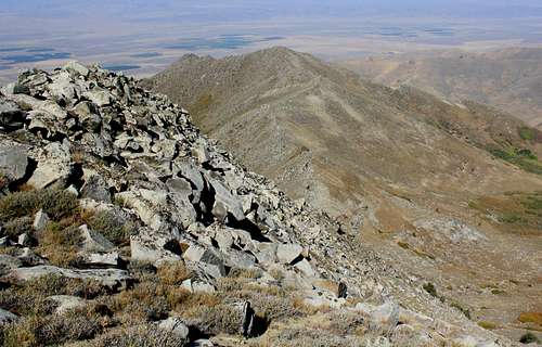
Finally the last 700 feet of the mountain was a climb up through steep granite, with an entertaining scramble up through very large boulders at a fairly steep angle. The highlight here for me was jumping from one boulder to another over a span of 3 or 4 feet. Once the summit ridgeline was gained it was just a short traverse to the summit. The views were nice, but unfortunately wildfire haze limited views drastically. We could see the silhouette of ranges out to about 30 miles. When I had climbed Granite a couple years earlier I was able to see ranges nearly 200 miles away.
![Looking back down the West Ridge]() Looking back down the ridge
Looking back down the ridge
Thanks to Troy for joining me on this hike, and Dennis Poulin for providing route directions and advice.
Here is a link to the trip report I posted on climbing nearby Granite Peak a couple years prior. The views of Santa Rosa Peak from Granite were outstanding, and motivated me to continue making the long drive down here to climb these remote mountains.
May in the Santa Rosa Range


Comments
Post a Comment