
|
|
Route |
|---|---|
|
|
46.71219°N / 11.84765°E |
|
|
Hiking, Via Ferrata |
|
|
Summer |
|
|
Most of a day |
|
|
EEA - Alpine F |
|
|
Overview
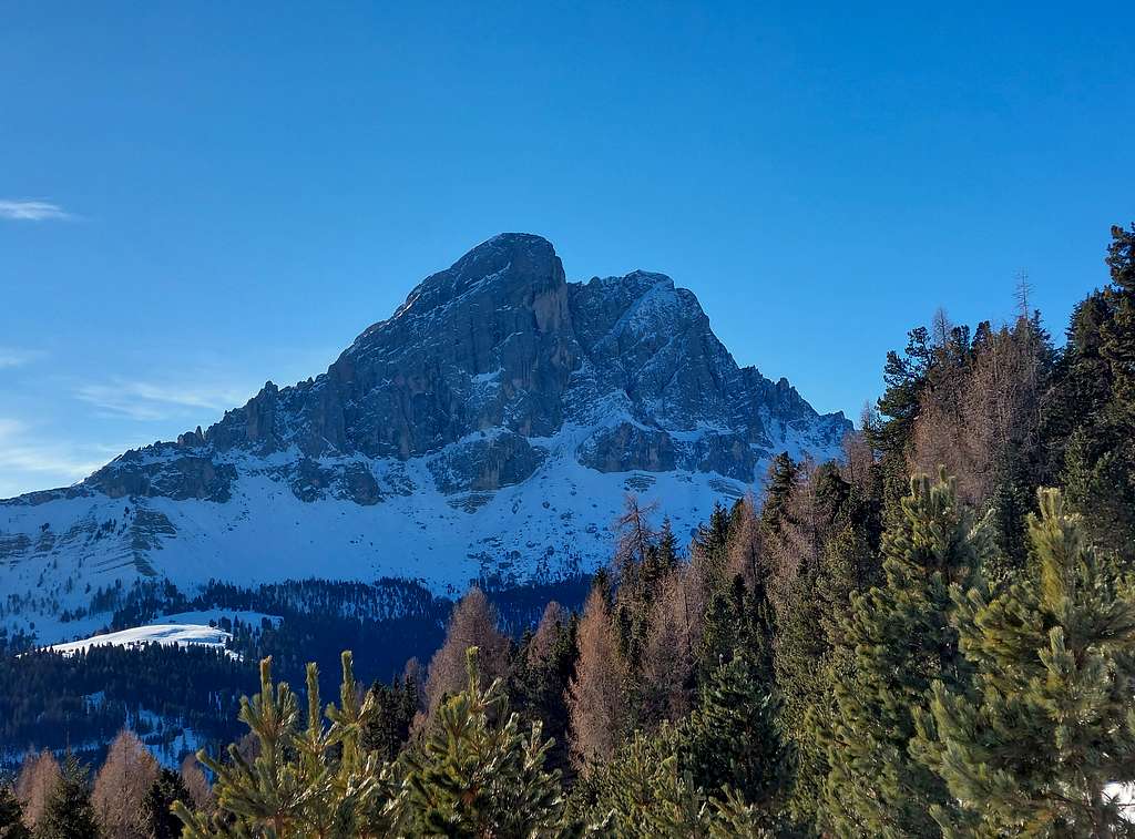
Sas de Pütia/ Peitlerkofel loop from Passo delle Erbe
Sass de Pütia 2875 m - Peitlerkofel in German - is an imposing and isolated peak in the Dolomites overhanging Passo delle Erbe (Würzjoch -1987 m) with its vertical and impressive North face, which does not allow one to imagine how easy it is to climb the mountain top from the South flank. Passo delle Erbe is an alpine pass located between the beautiful Luson pastures to the North and the steep rock faces of the Sass de Putia to the South.
The route described in the following chapters allows you to reach the summit of this great mountain by means of a long hike and a short final stretch of Via ferrata and also to complete the circumnavigation of the mountain through a long ring with departure and arrival both on Passo delle Erbe.

|

|
Getting There
The starting point to climb is Passo delle Erbe/Würzjoch 1987 m, a road pass connecting Val Badia with Valle Isarco and Val di Funes.
Road access to Passo delle Erbe
Across Val Pusteria - from A22 Autobrennero exit Bressanone and take the road to Brunico (Val Pusteria). Just before reaching Brunico, leave the Val Pusteria road and take on the right the road to Val Badia. Once getting the village of San Martino in Badia leave the main road and turn right with signpost to Passo delle Erbe. You reach the pass just after passing the village of Antermoia.

Across Val di Funes - from A22 Autobrennero exit Chiusa (Klausen) and from here take the road 27 to Val di Funes. At the hamlet of San Pietro take the SP 163 up to the hamlet of Colle, where you take the road 29 to Passo delle Erbe.
Route Description
Summit of Sas de Pütia from Passo delle Erbe full crossing
Difficulty: EEA (the rocky section)
Difference in level: 900 m from Passo delle Erbe to the summit plus some ups and downs along the loop
Time required: 7 hours

|

|
Fine and easy itinerary which involves the ascent to the panoramic summit of Sas de Pütia, plus a long ring around the mountain. Some slight difficulties only in the stretch of the final rocks, which are however entirely and optimally equipped with a fixed iron rope. However the entire ring is long with some ups and downs and requires good resistance.

Route description
From Passo delle Erbe parking lot, near the Refuge Ütia de Börz, take the wide gravel road (path n. 8A) that leads towards the mountain. After a few minutes from the start the trail passes in front of a spectacular geological stratification of red sandstones of the Val Gardena - dominated by the Ladin dolomites - which constitutes a sort of open book on the history of the earth.
Once on the meadows at the base of the wall, the path branches off at the alm Munt de Fornella 2080 m, where the path joins the ring path that surrounds the mountain. It is more convenient and pleasant to follow the circular route rightwards (counterclockwise), so it's advisable to turn to right and cross the Prati di Campaccio. Soon the itinerary becomes a narrow path that climbs gradually and with a long traverse crosses the base of the west wall of Sass de Putia. We descend slightly to a junction where we keep the left on the path n. 4 that climbs steeply up to reach the Forcella di Putia (Peitler Scharte) 2357 m, about 1 hour and a half from the pass. The Forcella di Putia, as well as being a nice panoramic point, is an important crossroad from which different routes depart.

|

|

|
From this crossroads on the saddle, turn to left and take the signposted path to the summit. Rising towards the top the path follows the grassy South side of Sas de Pütia and it's rather steep but without difficulty at the beginning. At a junction you can follow both the path to the left and to the right, the right one is shorter and more interesting, going up a short rocky stretch of 15 m up to a small saddle and from here joining the other path coming from the left. After other hairpins the route reachs a saddle with a rocky promontory on the right and the shoulder of Sas de Pütia, a flat gravel saddle below the rocky oucrop of the summit where it begins the short and easy Via Ferrata at the altitude of 2720 m.

|

|
In the last 150 m the climb takes place on steep rocks, anyhow very well equipped with fixed metal ropes, up to the exit on the last rocky steps that lead directly to the summit. Cross, summit book, 3 hours from the start. Given the isolated position of the mountain, the view is wide in every direction: to the north towards Aurine Alps, Vedrette di Ries, Ortles, Pala Bianca, to the South towards the various groups of the Dolomites, particularly the Odle and Sella groups.
 on the summit of Sas de Pütia")
|

|
From the top, reverse the uphill route following the Via Ferrata again. Back at the base of the Via Ferrata you can climb in about 15 minutes also the lowest W summit: along the hairpins under the shoulder there is an obvious fork to the right (descending) crossing the rocky slope and climbing up a short gravel slope to the minor summit. Whether or not you want to reach the lower peak, from the shoulder you need to reverse the uphill route down to Forcella di Pütia. Here the ring around Sass de Pütia continues on the left on the South side of the mountain, along a path in definite descent in the direction of an area of vast meadows, the Prati di Putia. The path, with some ups and downs, becomes larger with some sections on a wide mule track, passing close to some fine characteristic mountain farms.

|

|

|
Among vast meadow areas, the itinerary skirts the alm Ütia de Vaciara. After the hut the path heads sharply to the left at a signposted fork and then climbs up to Passo Goma 2111 m, where we pass again on the Northern side of the mountain. The trail heads steadily to the left, crossing, with some ups and downs, a sparse coniferous wood, getting Ütia de Goma hut 2030 m. We proceed through meadows and sparse groves to the alm Munt de Fornella, where the ring is completed. On the same gravel road of our start, we come back to Passo delle Erbe.
Essential Gear
Normal hiking gear. Harness and safety lanyard are advisable on the Via Ferrata.
Red Tape
No permits required. A parking fee is required to leave the car in the parking lot on Passo delle Erbe. Sas de Pütia is situated inside the Parco Naturale Puez-Odle, which is bordered to the North by Passo delle Erbe and to the South by Passo Gardena. To the East, the park extends to the Val Badia, westwards to the valleys of Funes and Gardena. The area Puez-Odle is one of the nine mountains systems of the Dolomites acknowledged as UNESCO WORLD HERITAGE and require the best care and respect. More info about Dolomiti Unesco World Heritage here on SP: Dolomites living mountains by Silvia Mazzani.

When to climb
Best period comes from June to the end of September
Where to stay
On Passo delle Erbe it is possible to stay overnight at Rifugio Ütia de Börz