
-
 7962 Hits
-
 80.49% Score
-
 12 Votes
|
|
Route |
|---|---|
|
|
36.16616°N / 115.44263°W |
|
|
Scrambling |
|
|
Spring, Fall, Winter |
|
|
Class 4 |
|
|
Overview
The routes up Red Cap originating from Sandstone Quarry, west of the peak, are short and a lot of fun, but they have three principal drawbacks:
- You have to pay the admission fee for the Scenic Drive.
- Because the Scenic Drive is 13 miles long and one-way only and Sandstone Quarry is 3 miles in, you have to drive practically the entire loop after your climb. While this will seem nice to first-time visitors, Red Rock veterans are likely to loathe the wasted time and the slow traffic.
- The Scenic Drive is not open 24 hours. Basically, it is open from dawn to dusk, which is more than enough time to climb the peak, but it does hinder those looking for very early or very late starts.
Calico Basin, to the east, offers a nice alternative. The route is about twice as long and not quite as much fun, but there is still plenty of nice scenery and some pleasant scrambling, and it can still be done in just a few hours round-trip.
Getting There
From Charleston Boulevard (Route 159) west of I-215 and Summerlin, turn onto the signed road to Calico Basin; this road is about one mile east of the entrance to the Scenic Drive in RRCNCA. Keep right when you reach the spur to Red Springs Picnic Area and soon bear left onto Sandstone Drive. Follow that road to its end; there is a large and obvious parking area on the left. The distance from 159 to the parking area is about two miles.
Route Description
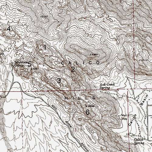
Peaks of the Calico Hills
RT distance is about 4 miles, with approximately 1300' of elevation gain.
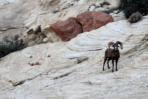
As you look north from the trailhead, the two peaks before you are, left and right, New Peak (Peak 4987 on the map above) and Kraft Mountain. The Calico Hills are to left of New Peak, and your route is going to use the drainage leading to the saddle between New Peak and the Calico Hills (Red Cap is Peak 1 on the map).
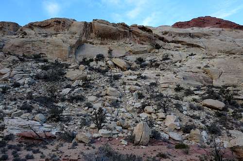
Start hiking west on a good trail toward Ash Creek Spring. Soon the drainage to follow comes into clear view. Near the base of the Calico Hills, head for the drainage via a use trail or a cross-country path. Note: you can also take a trail north to eventually reach the saddle between New and Kraft, but the cross-country jaunt from that trail to the drainage involves some ups and downs that most would prefer to avoid.
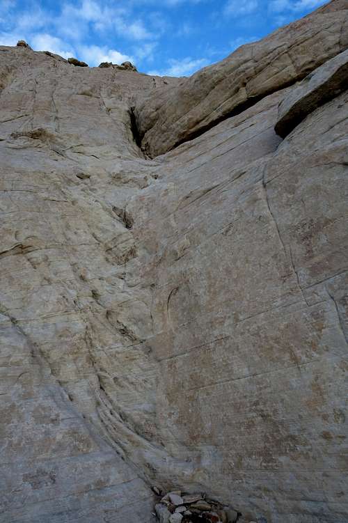
The drainage (small canyon) is a mix of hiking and scrambling. Cairns sometimes help with ways around large obstacles or brushy spots, but they are hardly crucial as navigational tools. As you get closer to the saddle, look for a well-established use trail above the canyon on its right side. You may also note a use trail from the vicinity of New Peak's upper southern side joining this trail. From higher up, one can see the trail coming from the sandstone outcrops on New Peak's south face, but whether it joins the trail to the New-Kraft saddle or not, I do not know. If it does, this would probably be a faster and easier way to reach the saddle between New Peak and the Calico Hills.
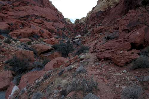
Drainage to the Saddle
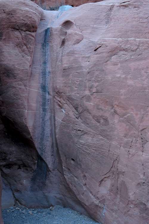 Waterfall Obstacle in Canyon-- Upper Drop | 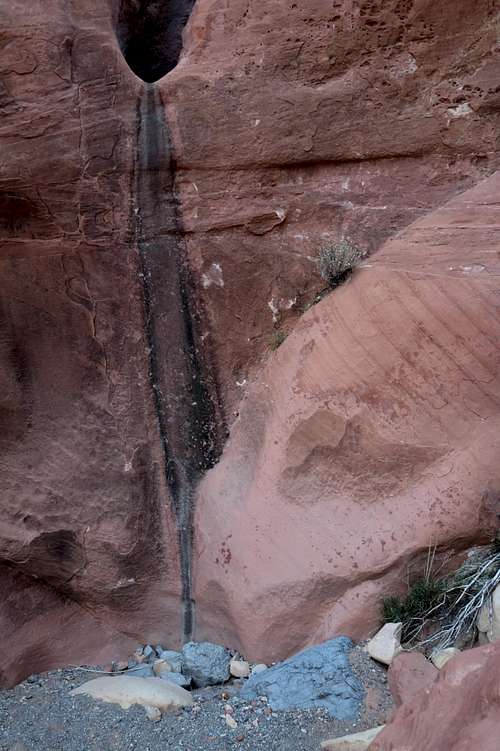 Waterfall Obstacle in Canyon-- Lower Drop |
My climbing companion in the canyon
From the New-Calico saddle, you can actually see the red-tipped summit of Red Cap, though the rocks you see are actually the slightly lower eastern summit, not the true summit. here, different options may exist. What worked for me was first heading west to the cliffs and then traversing south a bit to utilize some weaknesses granting me access to higher ground. I've also seen a route map that showed somebody heading a bit farther south than I did before heading up. The course I found had a couple short Class 4 spots, and the key was a short, semi-hidden tunnel I had to crawl through.
![Red Cap from the Saddle]()
Red Cap from the Saddle
![Short Wall]()
Short Wall
Ultimately, I found myself a little bit southeast of the summit, and I was able to pick up the final portion of the South and West Faces route:
Red Cap from the Saddle
Short Wall
Ultimately, I found myself a little bit southeast of the summit, and I was able to pick up the final portion of the South and West Faces route:
Spot some dryfalls and a gully just to the right of them. Climb the gully (Class 3) until you are at the top and next to a red block that seems to be the summit. It isn't, but it's easy to scramble up this block and see the true summit a very short distance away.
Descend a short distance (50-60 vertical feet) in a gully on the other side, and then, where yet another gully joins the one you're in, just before a brushy spot, climb up that gully to reach a notch; this is the notch above the dryfalls on the other side, and you are between the subsidiary summit and the true one. Now descend about 15 feet back onto the south side to a tree and then climb to the right up a short Class 4 wall.
When you reach easier ground, hike left around the summit block until on the northwest side you reach a short (about 8') crack that goes at Class 3+/4. This crack is next to what may be the standout feature of Red Cap, a small tinaja just below the summit. Please stay out of the water in order to protect the fragile organisms that make it their home.
Climb the crack and then walk to the summit, which is less than a minute away.
On the south side, instead of climbing the gully next to the dryfalls, climb one of the dryfalls. Both are Class 5, but both are climbable for skilled scramblers experienced with going unroped on Class 5 terrain. The one on the right is the easier one, mainly because it is fairly easily accessed via a short exposed traverse from a boulder to its right (the bases of both dryfalls are difficult to start from; the one on the left is wide with smooth, overhanging rock, and the one on the left is sheer and smooth); 5.2 seems about right to me, but it is not harder than 5.4.
Above the dryfalls, you are just below the short Class 4 wall mentioned previously that accesses the summit block, so this route removes some of the zigzagging nature of the main route.
If the dryfalls are not to your liking or are in bad condition, follow the main route as described but instead of descending from the notch to the Class 4 wall, climb up and to the right from just below the notch (on the north side, to be clear). This is maybe 25' of Class 4 climbing and lands you directly at one end of the tinaja. Walk around the tinaja to the 8' crack and finish the climb.
The benefit of this route is that it is slightly shorter and, of course, adds variety. It does not change the difficulty much at all; the Class 4 wall here feels slightly easier than the Class 4 wall on the south side.
 |  |  |
Descend a short distance (50-60 vertical feet) in a gully on the other side, and then, where yet another gully joins the one you're in, just before a brushy spot, climb up that gully to reach a notch; this is the notch above the dryfalls on the other side, and you are between the subsidiary summit and the true one. Now descend about 15 feet back onto the south side to a tree and then climb to the right up a short Class 4 wall.
 |  |  |  |
When you reach easier ground, hike left around the summit block until on the northwest side you reach a short (about 8') crack that goes at Class 3+/4. This crack is next to what may be the standout feature of Red Cap, a small tinaja just below the summit. Please stay out of the water in order to protect the fragile organisms that make it their home.
Climb the crack and then walk to the summit, which is less than a minute away.
 |  |  |
Variation 1
On the south side, instead of climbing the gully next to the dryfalls, climb one of the dryfalls. Both are Class 5, but both are climbable for skilled scramblers experienced with going unroped on Class 5 terrain. The one on the right is the easier one, mainly because it is fairly easily accessed via a short exposed traverse from a boulder to its right (the bases of both dryfalls are difficult to start from; the one on the left is wide with smooth, overhanging rock, and the one on the left is sheer and smooth); 5.2 seems about right to me, but it is not harder than 5.4.
Above the dryfalls, you are just below the short Class 4 wall mentioned previously that accesses the summit block, so this route removes some of the zigzagging nature of the main route.
Variation 2
If the dryfalls are not to your liking or are in bad condition, follow the main route as described but instead of descending from the notch to the Class 4 wall, climb up and to the right from just below the notch (on the north side, to be clear). This is maybe 25' of Class 4 climbing and lands you directly at one end of the tinaja. Walk around the tinaja to the 8' crack and finish the climb.
 |  |
The benefit of this route is that it is slightly shorter and, of course, adds variety. It does not change the difficulty much at all; the Class 4 wall here feels slightly easier than the Class 4 wall on the south side.
Or, climb the gully beside the dryfalls and, once above them, make a short, exposed traverse over to the Class 4 wall.
Extended Route Option
From Red cap, it is possible to head south to Calico Tank Peak. Expect some Class 3 and 4 spots, and look for cairns to save a little time. Give yourself at least an hour to make the traverse, though I have done it in half that time. If you're lucky, you'll pass two tanks that relatively few ever see; you can see these tanks from Red Cap's summit.
Afterward, either retrace your route or descend (Class 3) to the saddle between Calico Tank and the peak immediately southwest of it. Then descend east through the obvious drainage (non-technical but does have some Class 4), known as Ash Canyon, back to Ash Creek Spring and from there back to the Calico Basin trailhead. For this, too, give yourself at least an hour.