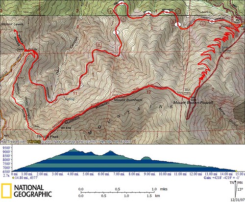
100th Peak
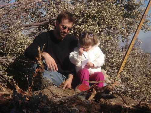
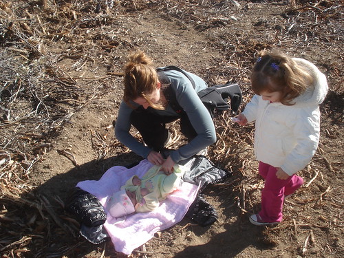
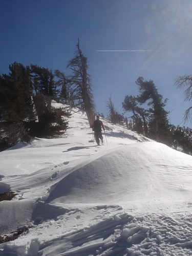
It is December 31th, 2007 and I am standing on top of Circle Mountain with my beautiful family. This is my 100th peak (explanation follows in next section). There are other reasons to celebrate too, this is my daughter Farrah's first peak, my daughter Kenzie's 9th peak and my wife's 6th. I had set a goal early this year to hike 100 peaks prior to the end of the year, and I have just barely managed to meet this goal. It is nice to be able to share this experince with my family, and I am really enjoying the time on the summit. My daughter and I sign the summit register, I take a short video, have a short play session in a small patch of remaining snow, and head on our way. I have promised my daughter a parfait (as Kenzie says, that is a fancy way of saying Sundae) at a restaurant in Wrightwood and we are all hungry. Circle Mountain is an easy peak, other than a few very steep sections the hike up and down is uneventful. I am carrying my 3 year old daughter on my back and my wife is carrying our 3.5 month old in a carrier on her chest. Since I accidentally parked at the wrong location the hike was a little longer than necessary, 4 miles and 1200 ft gain. Long enough for both mine and my wife’s back to get sore hauling our precious cargo.
Background
I feel necessary to clarify my 100th peak. I am referring to 100 of the Sierra Club
Hundred Peaks section (HPS) peaks and I am what is often referred to as a peak bagger. Peak bagging is an activity in which hikers and mountaineers attempt to reach the summit of some collection of peaks, usually those above some height in a particular region, or having a particular feature. Most SummitPost members I would consider as peak baggers, since we all track our peaks climbed via the electronic summit logs and usually work towards climbing more and more peaks (usually within a geographic region or with a particular feature). The term peak bagger is sometimes viewed negatively since “Bagging” a peak is akin to conquering peaks and therefore climbing them for the wrong reasons. I am not crazy about the term either and have refrained from calling myself a peak bagger in the past, but it appears to be the term that stuck for someone like me who works towards attaining a group of peaks. Regardless of the name, I do not agree with the opponents of peak bagging. I climb peaks because I love to be in the outdoors, like to stay in shape and I love to challenge myself with goals. Peak bagging allows me to do both of these while respecting nature and the mountains.
Peak bagging is a form of highpointing (but not vice versa since not all highpoints are peaks) in which people can set goals to hike the highpoints within any geographic region (counties, states, countries or even
continents). There is usually local mountaineering or hiking groups that also have goals to attain the peaks within a certain geographic region. Such as the Sierra Club’s
Sierra Peaks Section,
Hundred Peaks section,
Desert Peaks Section,
Lower Peaks Committee and Climber.org’s
Costal Peak List. Not to mention the array of organizations for climbing 14’ers (14,000”+ feet high) peaks of every state. Plus excellent websites like our www.summitpost.org allow hikers of all types to record their summits in electronic summit logs and to share experiences.
Working up to 100 Peaks
12/23/2007 Peaks 91-93
A few days before Christmas Tom, his dog Coco and I decided to attempt a winter hike near Mount Baden-Powell. We drove out past Wrightwood to Vincent Gap at the gated end of the Angeles Crest Highway (ACH). It was a beautiful, clear morning but not too cold. We were the only car at the usually busy Vincent Gap parking lot. Since we were hiking on the north side of the mountains we were expecting snow and cold, and we were not disappointed. We followed a snowboarder and skier’s tracks all the way up to Mount Baden-Powell. At first the snow was only a few inches deep, but it got progressively deeper as we ascended. Near the top the snow had drifted into some very deep areas and our progress was a lot slower than usual.
It took us over 2.5 times longer as usual to reach the cold, windy summit of Baden-Powel (2.5 hours). Since the summit was so exposed and windy we quickly left seeking a warmer rest stop. We headed west along the ridge towards Mount Burnham until we found shelter from the wind for a nice snack. Whereas the north side of the ridge had deep drifts of snow, most of the south side was barren. A lot of difference sun exposure can make. We followed the ridge along the south side when possible all the way to Mount Burnham (#91) and then on to Throop Peak. It was still tough going, since often we were forced to hike along the ridge and deal with deep powder snow. Post holing is very tiring, especially while ascending. Plus we had to loose and regain a lot of elevation in order to attain Throop, the saddle was lower than I expected. Once on Throop (#92) we ate lunch, enjoyed the amazing clear views and then descended to the ACH via Throop’s north ridge. There is a trail most of the way, but for a good portion of the ridge we had to trudge through deep snow until we descend to lower elevation and the snow decreased. I really enjoyed this ridge, it was gentle and scenic. I recommend this route.
It did not take long to reach the ACH at Dawson Saddle along the closed section of the ACH. From here we quickly ascended Mount Lewis (#93). It was an easy hike and the summit was not overly rewarding except for the amazing views and beginning of a sunset. I had never before seen such clear skies.
We then descended back to the ACH and walked along the highway for 5 miles back to Vincent Gap. It was all downhill and the road had been plowed so it was easy. We also were able to see some of the repairs going on to hopefully open this highway again soon. In the end it was 15 miles and 4200 ft elevation gain. A nice hike and an enjoyable winter experience.
12/28/2007 Peaks 94-99
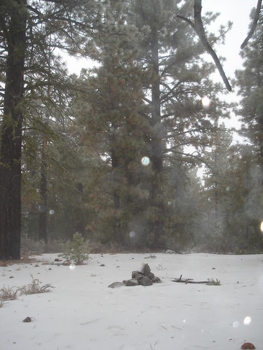
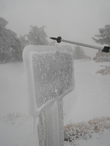
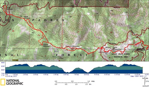
On Dec. 28th, 2007 Tom had planned a peak bagging trip to help me obtain my goal of 100 peaks and explore some relatively close mountains near Frazier Park. We meet just off the I5 at 7:00 am and headed off. It was lightly raining and we were nervous as we were not prepared for rain. We started off for what we thought was going to be a drive-up summit of Cerro Noroeste, however we quickly ran into a closed gate and had to change plans. Instead we headed off for Brush Mountain (#94) which was a short hike. Tom had just bought a Honda Element and we were prepared for the rough roads and potential snow for these hikes. The drive up to Brush was straightforward until the final section. It was really steep and washed out. At this point we decided to hike to the top rather than risk getting the new element stuck. It was raining a little harder as we quickly hiked to this uneventful summit. We could not find the summit register, but did not look hard. There were some neat ice formations near the summit, but no views.
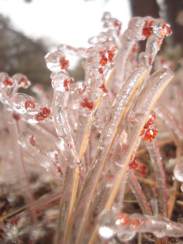
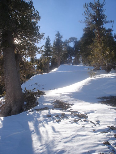
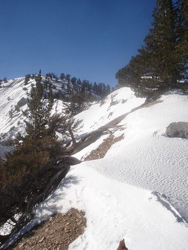
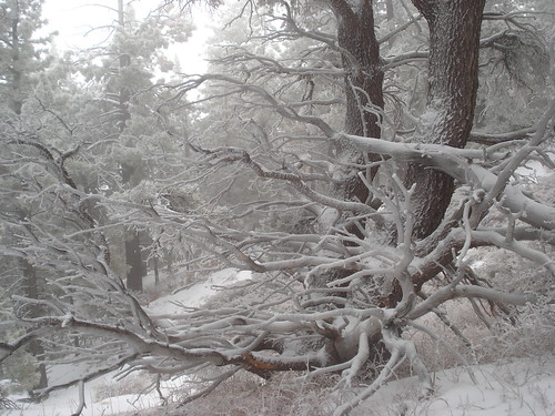
We trucked back to the truck and headed off for another easy peak, San Emigdio Mountain (#95). For this one we were able to drive about 250 yards from the summit. It was an easy peak and the rain was starting to turn into snow near the summit. We then drove off for Mount Pinos in order to hike the ridge to Cerro Noroeste from the other direction than originally planned. We expected to be able to drive to the summit, but found out that the gate was closed 2 miles from the summit. This would mean that the hike we expected to be 4 miles in and 4 out for a total of 8 miles would be closer to 12 miles. Also, the conditions changed dramatically at this slightly higher elevation. It was snowing and blowing very hard. It was also very cold. When we let Tom’s normally eager hiking companion Coco out, she walked around, felt the cold and wind, and had a not-so-eager look on her face with her tail slightly between her legs. We put on most of our cold weather gear and headed out with doubt that we would be able to make it all the way to Cerro Noroeste. The hike to Mount Pinos (#96) was beautiful and cold. There were amazing ice formations over everything. Some of the pine needles were 1” diameter of solid ice.
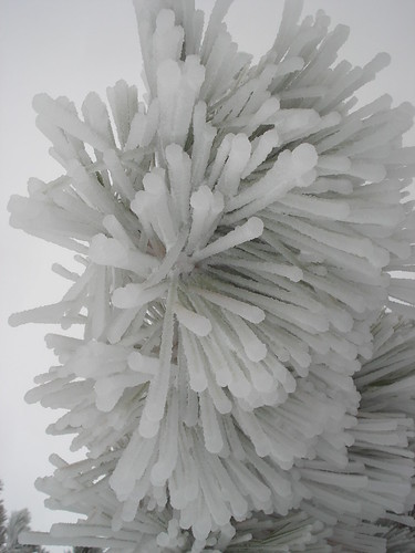
The summit itself was even more ice plastered, cold and windy. Everything had a least 1” of solid ice covering it(glazed), making for a surreal setting. From there we quickly decided to continue on to Sawmill Mountain and headed down the mountain towards the west. The trail was covered with deep snow and required losing a lot of elevation. We followed one set of footprints most of the way down, sometimes on the trail, often not and going straight down. Tom reminded me that we are going to have to regain all of this elevation loss, plus even more if we continued on to Cerro Noroeste, but I didn't want to think about that at this point. Soon we had descended all the way to the saddle and then left the trail to climb up to Sawmill Mountain (#97).
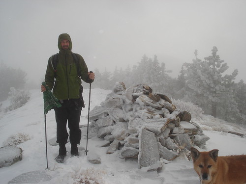
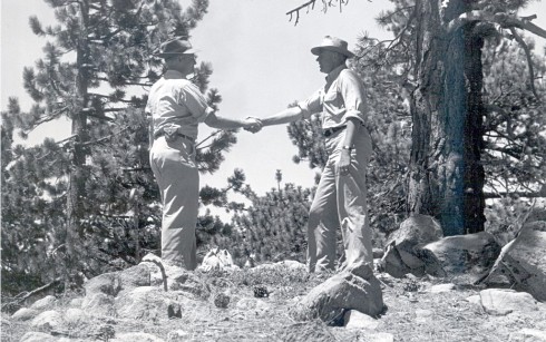
Sawmill Mnt. was also cold, windy and ice plastered so we left quickly and decided without words to continue on to Grouse Mountain (#98). We were able to stay on the trail until the final ascent of Grouse where we left it in order to reach the summit. I had plans of getting a
photo of shaking hands with Tom to celebrate my 100th (-2) peak similar to the original 100th peak in 1946 by
Weldon Heald on this same peak, but as plans often do this one was dropped. At this point Tom was reluctant to continue. We had to loose additional elevation to reach the saddle for Cerro Noroeste and then regain most of it back. We figured at least 1800 ft to get back to where we were. But I was eager to proceed and little encouragement got Tom and Coco to agree to continue. We left cross county to regain the trail, however with limited visibility it is sometimes easier said then done. MY GPS quickly told me that we were on the wrong ridge so I corrected and headed sharply north only to have to head west again. We found what we though was the trail a couple times, only to loose it again. My GPS had the trail shown in a different location which caused confusion. Once we found the trail again I asked Tom to lead since I was doing a bad job at staying on the trail (afterwards I realized I probably should have put my glasses back on, but they kept fogging up). Tom seemed to have no problems staying on the trail and soon we had reached the saddle and started to climb again. I was a tough climb to the summit of Cerro Noroeste (#99).
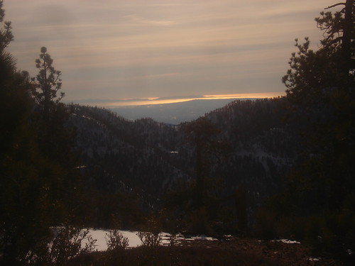
We found shelter under a pine tree near the campground and ate lunch and then turned around and headed back. The hike back was tough and it took 2 hours to reach Mount Pinos. The timing was perfect, as the skies were clearing and the sun getting low on the horizon. I don’t think you can get much better photo opportunities I took many photos and truly enjoyed the beautiful scene that nature presented to us.
![Sunset from Mount Pinos]() Sunset Views from Mount Pinos
Sunset Views from Mount Pinos
From Mount Pinos we made quick work of the 2 miles back to the truck. The sun was fully setting by the time we reached it and temperatures quickly dropping. On the drive out we were treated to an amazing sunset in the warmth of the truck. A nice conclusion to a great day of hiking, 13 miles, 3800 ft elevation gain and only 1 peak left in order to reach my goal of 100. Upon signing the summitpost summit logs afterwards I realized that I had also hiked 2 additional county highpoints, making 10 in total (not that I am really keeping count, yet).
What’s Next?
I am not sure. I am contemplating setting a goal of another 100 peaks for 2008 but need to make sure that is realistic first. Regardless, I will continue to hike HPS peaks and work towards all 276 (+/-) peaks. I achieved most of my initial 100 peaks in the San Gabriel Mountains, so I will need to explore other mountain ranges to do this. I also want to hike a lot more of the Sierra peaks and other significant peaks in North America if possible. I would like to get my family more involved in hiking peaks if possible, as it is a difficult balance between family and hiking and by combining them I can get more hiking and family time.
I would like to hike a glaciated peak in 2008, either Shasta or Rainier.
Bechtt is trying to get me excited about climbing volcanoes in Mexico, which sounds great if I can coordinate it.
I am also planning on trying new routes to some of the peaks in the San Gabriel Mnts. For example, Mount Baldy via Big Horn Ridge. Mount Baldy via San Antonio Ridge. Big Iron Mnt. via Southwest ridge and of course, Triplet Rocks.
GPS Data and Photos
The following links are to my website that contains GPS Tracks, photos, Google Maps and a video:
Circle Mountain
Mount Baden-Powell Peaks
Frazier Park Peaks
2007 Highlights
When starting a new year and working towards a new goal, it is customary to reflect on the previous year’s highlights. Here are mine.
Strawberry Peak – I really enjoyed the class 3 route from Josephine saddle and the car shuttle made it possible to descend a different route (something I always prefer).
Mount San Jacinto – Hiking this peak from the bottom (Cactus to clouds) was a real test of my endurance and the most elevation gain I have ever done in a day.
Mount Baldy and the Three Tees +1 – This is a classic. We started from the Village, hiked to Mount Baldy, on to
Harwood and then hit
Thunder,
Telegraph and
Timber. It was a hot July day as well.
Sugarloaf, Ontario, Bighorn, Cucamonga and Etiwanda – A great hike led by
Bechtt. Wrote a
trip report on this one. The initial ascent was fun up
Falling Rock Canyon and another enduring day of 5 peaks.
Twin Peaks – The hike itself was nice, we also hike to the summit of Watterman. But what made this hike special was the exploratory section down the east ridge of Twin Peaks towards Triplet rocks. These rocks are still on my to do list.
San Bernardino Ridge – This hike holds my personal record of the most peaks hiked in one day, 9 in total, but not all were HPS peaks. I also wrote a
trip report on this one.
Yucaipa Ridge Traverse – What made this hike special was the ascent to Little San Gorgonio following the steep drainage then onto an even steeper ridge. I plan to be back to hike Mount Gleason via the headwall and then traverse to Little San Gorgonio and down the drainage. Another
trip report for this one.
San Jacinto Peaks – A great hike with
Mountain Impulse of the 7 peaks around and including Mount San Jacinto. Several involved class 3 approaches and mainly cross country. Mountain Impulse wrote a
trip report on this one.
Video
Here is the video I took on the Summit of Circle Mountain.


Comments
Post a Comment