The Appoach: Clohesy Lake, Where Art Thou?
Missouri Mtn (14067')
Iowa Pk (13831')
Emerald Pk (13904')
Jan 29-31, 2010
23 miles RT, 6100' gain
Death Marchers: Dominic, Sarah, Jamie, & Kevin
From County Road-390 (9040')
The Approach:
8 miles, 1900' gain
Slideshow
With another bluebird January Saturday in the forecast, another winter 14er backpacking trip was in order. The Missouri group would be a nice prize to be had, but we didn't have enough time to pull that off without a day off work for Dominic and I. We tossed around doing a variation of the standard route from Missouri Basin so we could get Belford and Oxford, but we were worried that there wouldn't be a safe line to gain the northwest ridge of Missouri.
We settled on Missouri from the west with a camp at Clohesy Lake. Missouri is probably regarded as the 2nd toughest Sawatch 14er to attain in winter because of the long approach. Sarah and Jamie signed up to break trail for Dominic and I Friday morning to Clohesy Lake, but it would require a pack in all in the dark for Dominic and I. I'll start whenever if I have a broken track! Let the craziness begin!
I arrive a bit late but am pleased to make it farther up the road than I anticipated. We're able to get all the way up to 9040 feet about 3.1 miles east of Vicksburg. I tell Dominic that we may be able to knock this out in 4 hours even with heavy packs! We set out at 7:09pm under a bright full moon. This is the first time I have done the entire length of a backpack approach in the dark. It was surreal taking in the quiet, windless night with the moonlight reflecting off the peaks above. I didn't even use my headlamp until we were deep in the woods since it was so bright.
We cruise up the road at a nice clip as we're blessed with a snowmobile track that actually went through after Sarah and Jamie! We pass the Vicksburg trailhead and are surprised to see a guy camped along the road just above it. We chat briefly and he said he made an attempt on Huron but was turned back by deep snow. That's a hefty solo attempt from so far below the summer trailhead! We tell him we're headed for Clohesy Lake for an attempt at Missouri tomorrow and he looks at us like we're a couple of loons. Little does he know that we have sloeshoe slaves ahead of us!
We make it to Rockdale in a bit over two hours and find our track down to the creek. After one missed turn, we're back on track and cross the creek with no problems as it is totally drifted over and frozen solid. Up the forest road we go and we slow down quite a bit. Sarah and Jamie have laid down a major league trench for us, and it's still a bit of work following them!
Evidence of the dandy trench work on the hike out:
There is evidence of an old previous track. A deli sandwich is strapped to the top of my pack. Could a mountain lion be lurking to pounce on me? No worries, because I have Aquaman with me to save the day, although he's a bit under the weather after eating a bad hotdog.
Postholing increases as we slog and slog our way up. I can't imagine the effort put forth to break trail! I look at my GPS over and over. I think I'm about to go delirious as progress is slow. We finally make it to camp at 11:49pm. Sarah is still awake and she has stamped out a nice platform for my tent! Our site is at 10860' in an open meadow just north of the summer trailhead. Sarah reports that it takes them over 8 hours to break trail in the rotten snow. Dominic and I feel like we're cheating. Man, I better do a lot of trail breaking tomorrow!
Missouri, Here We Come
A short night goes by fast and we are back at it again at 7:46am. I take the first turn at trailbreaking and it is indeed brutal work. Our plan of attack is to get out of the trees ASAP so we can escape this wallowfest. Once we crest the little hill n.e. of the lake, we head due east, breaking out of the trees after considerable effort at 11200'. We're delighted to find a safe albeit very steep line to the west ridge. We leave our snowshoes on and climb a steep slope with hard snow. This turns out to be a killer calf workout!
Dominic leads the way up the Missouri express to the west ridge:
This slope seems to take forever to scale before it finally relents at about 12000'. From here, it's a little under a mile and almost 2K vertical before the route joins the standard northwest ridge. The day is turning out to be a classic bluebird day with minimal winds. We strip down to our base layers in the middle of winter!
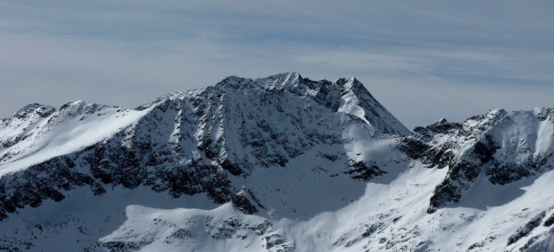
Ice and North Apostle in the limelight:
The ridge is easy, but seems to never end. There are a couple steep sections of talus, but they're broken up by mellower areas. It seems like we are hiking in molasses though. Where is that elusive Missouri summit? We finally gain the northwest ridge and the wind picks up enough to put the soft shell back on. We're less than 200 vertical and .6 mile from the summit, but there's a lot of work to do.
The undulating ridge is easy enough as we're happy to be able to cruise for awhile, then we come across our first obstacle, a couple of minor pinnacles that we scramble over. With an avy forecast of considerable risk for all aspects, we're a bit apprehensive traversing below on snow. We slowly make our way across.
After scooting across these, we posthole our way across a heavily drifted snow bridge with a minor cornice on the west side. As I step in Dominic and Sarah's tracks, a little chunk of it breaks off! As you can see here, this little cornice is harmless but it sure caught my attention!
Me scooting across the ridge. Pic courtesy of Sarah T. Meiser:
Missouri is a well guarded mountain in winter, and it looked like there was a chance we wouldn't be able to get by the difficulties from a distance. The summer trail skirts below a cliff band, but it was buried in deep, steep, unstable snow.
The little cliff band doesn't look near as formidable up close as it's a snowy class 3, but I'm worried that it won't go beyond that. I tell Dominic and Sarah that I'm going to traverse below on snow, but Dominic reports it's an easy although highly exposed class 2 on snow with no more climbing.
Dominic and Sarah on the ridgecrest:
I follow and take my time across the ridgecrest with ice axe in hand. The north face looms below on this airy perch and serves as a reminder to make sure of your footing! I use my axe in the rock for a couple spicy moves, but it's more mental than anything else. As promised, the going is easier and only a bit of postholing is left to the summit. I top out at 1:43pm and we soak up the winter views. The last time I was here, I only hung around long enough to sign the register, so it was nice to enjoy the summit of my home state on a perfect winter day.
Iowa, Emerald, & The Demoralizing Descent
It looks like we have enough time to scoot on over to Iowa and Emerald with about 4 hours of daylight left. It's an easy ridge run over to Iowa and we're happy to see Jaimie summitting Missouri as we climb Iowa. He had to endure a pack with no hip belt, so kudos on persevering to the summit!
Iowa and Emerald from Missouri:
It takes a little under two hours to get over to Emerald as we drop our packs at the Iowa/Emerald saddle and scope out a line down the west side back to the looming basin below. Emerald's north slopes are steep, so we cut left to gain the northeast ridge. We top out on Emerald at 3:42, but don't hang around long knowing that we'll have to break trail again back to the lake. If only we knew how bad it would get!
We make quick work down to the flats descending steep dirt, talus, and shallow snow. The sunset provides a stunning show over Unnamed 13517, a view that few have a chance to behold.
Sarah takes a nice line, taking a descending traverse to the northwest to cut off as much distance in the valley floor as possible. We hit the trees and things get real steep, so we stay close to the trees in the deep powder. The valley floor finally arrives, but the suffering has only begun. We have 1 mile left to regain our morning track near the lake, but it what would take 20 minutes in the summer took us 2 hours! It seems much longer than that.
I run out of gas and feel bad that I'm not helping enough with the trailbreaking. We have a hard time staying on the trail and wallow in the woods. I trip over deadfall time and time again as energy wanes. We finally make it to Clohesy Lake and realize that we're too low. The slopes above the lake are steep enough to slide, so we traverse the lake shore in search of safe terrain to regain our track at the top of the hill.
Willow bashing, sidehilling, and uphill postholing add to the misery. I take one final turn at trailbreaking and we crest a hill. Oh, it looks like we have one more descent and another hill to climb over there! We finally hit our track and it feels luxurious after a hard fought battle. We're back at camp at 8:18 and Jaimie is already done with dinner. He descended from the Iowa/Missouri saddle and was able to contour back to our morning track near treeline. I eat half my dinner and fall asleep in all of about 15 minutes and enjoy my best winter night sleep in the backcountry. What a day!
The dreaded pack out the next day was not as bad as I thought as visions of Pizza Works pizza dances in our head to replace the thousands of calories we burned. The track is in great shape with a few postholes here and there and we make it back down to the cars in 3.5 hours. We're glad we weren't up high today as the winds really picked up. Dominic and Sarah get stuck trying to turn around, and end up backing down the road a bit for a wider spot to turn around. Pizza Works can come no sooner. I must say Missouri in winter will go down as an epic!
GPS track:


Comments
Post a Comment