

-
 295278 Hits
-
 99.89% Score
-
 159 Votes
|
|
Mountain/Rock |
|---|---|
|
|
44.13740°N / 113.781°W |
|
|
Download GPX » View Route on Map |
|
|
Custer |
|
|
Hiking, Mountaineering, Trad Climbing, Ice Climbing, Mixed, Skiing |
|
|
12662 ft / 3859 m |
|
|
Overview
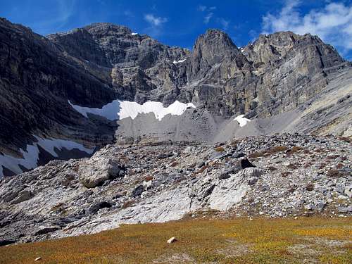 The East Face Cirque The East Face Cirque | 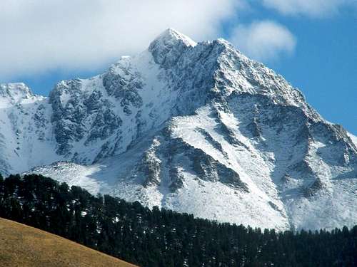 The North and West Faces Divided by the Northwest Ridge The North and West Faces Divided by the Northwest Ridge |
The pride of Idaho! At 12,662 ft Borah Peak is the monarch of the Lost River Range, highest mountain in Idaho. Known locally as Mount Borah rather than Borah Peak, this mountain boasts nearly 6000 feet of prominence, making it one of the rare prized ultra-prominence peaks. The standard route, aptly named Chickenout Ridge, is a semi-exposed third class scramble in late summer, but early in the season it can be an all-out mountaineering adventure including a narrow snow knife-edge ridge walk. Below the mountain on eastern and western flanks are low rolling grayish green valleys, beyond which rise more snow-covered peaks.
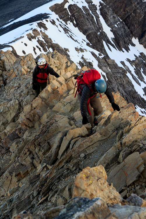
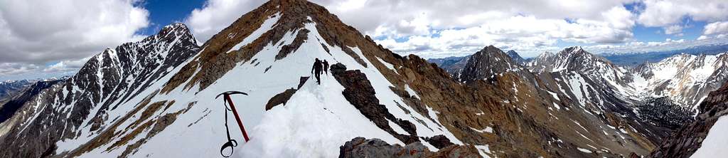 High On Chickenout Ridge
The peak itself consists of bare grey limestone and many of the adjoining peaks carry a similar grey appearance. Borah was first climbed in 1912 by T. M. Bannon, a USGS surveyor. In 1934 it was named for state senator William Borah aka "The Lion of Idaho" who ran in the presidential election of 1936. On October 28, 1983 a massive earthquake caused the summit to rise 7 feet. For this reason the true elevation of the peak may be higher than what is indicated on maps. The current fastest ascent/descent was done by Luke Nelson on October 22, 2010. His round-trip time was 2 hours 21 minutes and 11 seconds. Fastest Known Time
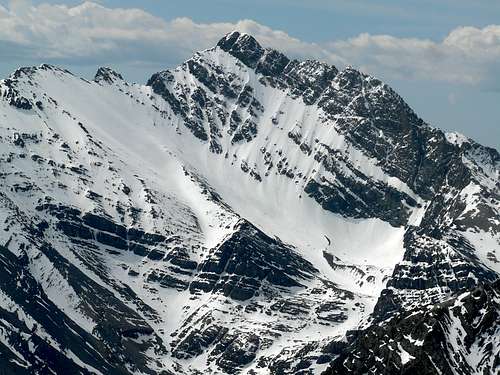 The North Face The North Face | 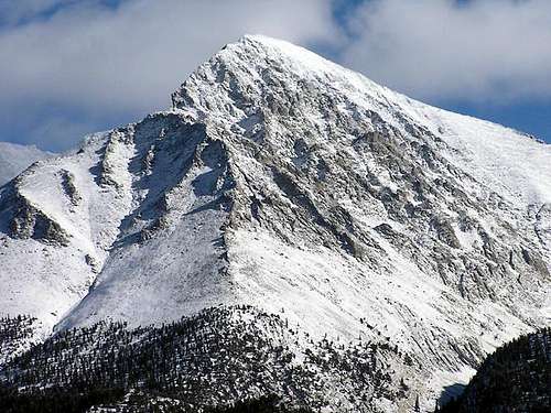 The West Face The West Face |
The standard route which begins in Birch Springs involves ascending 5,262 vertical feet from the trailhead to the summit in 4.1 miles. Most people do the climb in a single day. The scramble on Chickenout Ridge is the most famous route feature in all of Idaho. Many a hiker has returned home with the unfortunate story of how they had to turn around at the crux of the route. But it is important to listen to your gut and know when to turn around. There are also numerous technical routes on several sides of the mountain. See the routes section for more information.
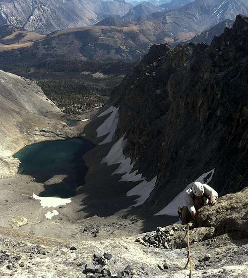 A Technical Route on the East Face
The truth about Chickenout Ridge is that it's not as difficult or exposed as all the hype makes it out to be. If the average hiker who has never ventured beyond a trail, or felt the thrill of exposure, attempts Chickenout Ridge, they might be scared out of their wits. But if the seasoned mountaineer comes to climb Borah he will likely end up scratching his head, wondering if that was Chickenout Ridge or if it is still yet to come on the remaining distance to the summit.
Standard Route - Southwest Ridge "Chickenout"
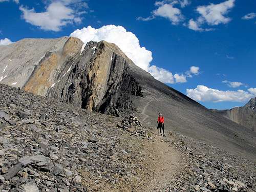
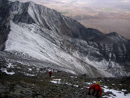
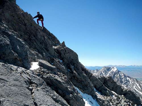
 Chickenout Ridge With Fresh Snow
Pick the line of least resistance. There are options on the left side of the ridge, the right side and on the spine, as well as various combinations. Generally speaking the rock is solid and trustworthy, considering how many thousands of people have been through it.
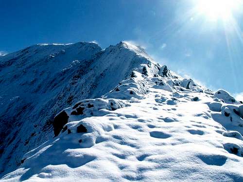
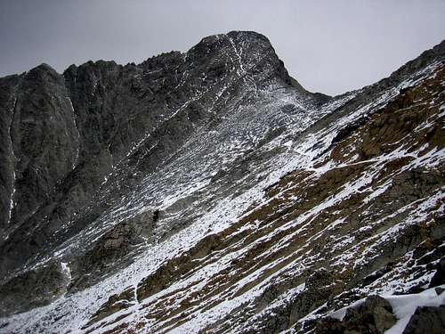
 Chickenout Ridge Crux Section
At the far end of the scramble section there is a steep step to scramble down. The next part of the ridge is narrow and this is where the snow knife-edge exists in early season. Many trip reports call this a "snow bridge", but it should not be confused with the natural formation which spans a crevasse on a glacier. Exercise caution here.
 Another View of the Crux Section
Beyond the narrow section you will come to the continuance of the trail as it traverses slightly down and turns north to bypass a high point on the ridge. At 11,750 feet the trail will regain the crest of the ridge and point you in the right direction for the remaining scramble to the summit.
 Ascending the Final Slope
The remaining southwest slope consists of bare slabs, ledges, scree and talus. Once again pick the line of least resistance and ascend in a northerly direction while being careful not to knock loose rocks down onto your partners. As of June 2014, there was a register on the summit. Please do not leave trash anywhere on the route and that includes trinkets or flags on the summit.
 The Final Slope
Mt Borah Route Overview
| Route Name | Rating (YDS) | Description, Comments |
| Class 3-4 | The standard way up Mt Borah and most popular route in Idaho. This route gains over 5300' in less than 4 miles and follows a well-worn trail most of the way to the summit. This route is Class 3 if one sticks to the easiest path but offers a number of variations that are a little harder. In late summer and fall this route is usually dry and requires no special climbing gear. When snow covered, this route may require an ice axe, crampons and a rope. Hiking poles are useful for the descent and for crossing the col when it's covered with snow. Descent is down the same route. | |
| North Face Direct | Grade II/III 5.7 AI3 | The North Face of Mt Borah is considered by some to be one of the finest alpine climbs in Idaho and one of the few faces that holds ice during most years. The lower face starts at around 45 degrees and steepens to around 55 degrees below the summit pyramid. This route takes the left branch of the main couloir until it ends at the short steep rock step (5.7) and then follows low 5th, 4th, and 3rd class steps directly to the summit. In the early season, (late spring and summer) this route is usually a steep snow climb. In late season (late summer and early fall) this route can be all hard alpine ice (10 pitches, WI3). In good conditions this route can be climbed in a few hours. In poor conditions this route can take all day. The Southwest (Chicken-Out) ridge is often used for descent. |
| North Face (Traverse) | Grade II/III AI3 | This route uses the same approach as most of the North Face lines. The ice will vary from year-to-year so pick the line through the rock bands that looks the best. All of the lower variations end at the top of the head wall at the base of the main couloir. From here traverse left across the steep ramp for approximately 3 pitches to the summit couloir or choose one of the other options to finish depending upon conditions. When in shape, the summit couloir is all ice and rears to around 60 degrees to finish about 20' below the summit. Like the Direct, in early season this is mostly a snow climb where in late season it is often all alpine ice. Trip Report 10-10-2010 |
| Psycho Therapy | Grade III 5.9 AI4 M6 | Of all the routes that have been established in Mt Borah's North Face cirque this one has stood out as the test piece of alpine climbing in the range. This route was first put up by Dean Lords and Bryan Woods in September 2003 (AAJ - Idaho 2004) and over the years resisted all attempts at a second ascent by some of Idaho's strongest alpine climbers. Both the first and second ascent teams described this route as being "run-out" and to quote Kevin, "hands down, the scariest lead of my life". As with most alpine climbs in the range, conditions play a big role in whether or not a route is in shape and rarely are they the same from season-to-season. In general, fall is considered the best time to find alpine ice on the North Face of Mt Borah, especially after a hard winter. However, this route is best attempted in late spring/early summer when there is still ample snow cover and (often) remaining winter ice. This route and Borah Borah Borah finish on the Northwest ridge and do not lead directly to the summit. Most climbers descend the lower spur of the Northwest ridge back to Rock Creek (west) instead of continuing on the ridge to the summit. |
| Grade III 5.7 WI3 M3 | This route uses the same approach as Psycho Therapy but goes up the left couloir to finish on the Northwest ridge. The rock band that guards the entrance to the couloir was described as a "death pitch" by the first ascent party even though its rating is only 5.7. Most of the Mt Borah technical routes are known for long run-outs with little protection and this one is no exception. Because the rock is a mix between Dolomite and limestone, it fractures in small seams. Much of the protection you can find is half inch or smaller. Most climbers descend the lower spur of the Northwest ridge back to Rock Creek (west) instead of continuing on the ridge to the summit. | |
| Grade II Class 4-5 WI2* | The Northeast ridge is usually climbed by using the North Face approach from Rock Creek (west). From the moraine, ascend the mile long class 2 hike to point 11,715. From there to point 12,247’ is a class 3 scramble. Traverse the ½ mile ridge and avoid the worst of it by staying on the right side of the ridge. The first difficulty is the steep 90' step above the col. In late July, 2012 we found water ice that required crampons and at least one ice axe at the start of the step. After the steep step, easy ground leads to the base of the final summit block from which there are several options depending upon the conditions. The upper Northeast ridge can also be reached from the East Face by climbing the face to the col on the right side of the cirque. | |
| Grade III AI3 | The Hidden Couloir is often overlooked because it can't be seen without hiking above the start of the other North Face routes. Because of its exposure, this route is often the first one to start showing ice in the late summer and fall. This is one of the shorter couloirs on the face and finishes on the Northeast ridge. Access is the same as the other North Face routes. | |
| Grade III 5.2 | This classic route was put up in 1962 and was the first technical route on Mt Borah. The first ascent party approached the face from Rock Creek on the (east) Pahsimeroi River side of the range. The approach can be shortened by a couple of miles if one drives to the campground at the end of the road on the West Fork of the Pahsimeroi River. The first ascent party rappelled down the East Face to descend back to the start. | |
| Dirty Traverse | Grade III Class 4-5 | This circuitous route began as a recon trip that evolved into a free solo push for the summit. This route takes advantage of the large dirty ledge that cuts across the entire East Face and is mostly 4th class. Descend from the summit using the Southwest (Chicken-Out) ridge to the start of the upper saddle at 11,800’. From there, drop off the east side of the ridge and make your way down 1,200’ of steep, chossy Class 3-4 terrain. This is a long descent over tricky ground forcing you to pay close attention to your feet and the possible difficulties below. There are often opportunities to glissade but the run-outs are pretty grim. The angle eases up at about 10,400’ making a further descent on snow the best option. Hike down to the highest tarn just below the 10,000’ contour line then start working your way back to the northeast and around the East ridge of Borah. |
| East Face Direct | Grade III 5.9 | This route pretty much follows a plumb-line from the base to the summit and is the hardest and most sustained route on the East Face to date. In general, the rock is solid and most of the climbing is mid 5th class with the exception of the 5.9 crux pitch. By late summer this route is mostly dry and other than the snowfield at the start, this route is all rock to the summit so rock shoes might come in handy. The Southwest (Chicken-Out) ridge can be used for descent of the East Face routes but this requires some kind of shuttle because you'll end up on the opposite side of the mountain from where you started. To get back down to the east, use the South Face route described above. This is a dirty, dangerous way off the mountain so use caution when using this route for your descent. |
| East Face-Northeast Ridge Variation | Grade III 5.6 WI2* | This route starts to the right of the Dirty Traverse and gains the Dirty Traverse ledge a couple of pitches below the very steep couloir that leads to the col on the Northeast Ridge. The crux pitch is below the Dirty Traverse ledge and has a short 5.6 section that leads to easier ground. Most of this route is 4th and easy 5th class climbing on good rock but all of the ledges are covered with rubble so expect some rockfall while climbing this route. Plan your belays accordingly and helmets are a must in this range. This route usually holds snow and ice so an ice axe and crampons are necessary. We had to use crampons three different times on this route and encountered a short section of hard water ice at the start of the Northeast ridge. During some years the col can be blocked by a large cornice. Descend by way of the South Face or make arrangements for a shuttle if you use the Southwest (Chicken-Out) ridge to get off the mountain. |
| South Couloir | Grade III 5.7 | This route uses the same approach as the other East Face routes until you reach the 10,000 contour where you traverse south into the Sacajawea drainage. Hike around the large tarn and continue up the drainage past the North Face of Sacajawea until you reach the bottom of the South Couloir. Follow the couloir to where it tops out on the upper saddle and finish on the Southwest (Chicken-Out) ridge. Descend by way of the South Face or make arrangements for a shuttle if you use the Southwest (Chicken-Out) ridge to get off the mountain. |
| Northwest Ridge | Class 3-4 | This ridge was climbed by Mike and Vaughn Howard and in December 1976. The lower Northwest ridge splits into two spurs and either can be used to gain the ridge proper. The approach is the same as the North Face (Rock Creek west) or from the Birch Springs road. The east spur is often used as a short cut to the North Face cirque. The ridge is a Class 3+ but like most of Mt Borah's routes, options are plentiful and it is easy to get into harder terrain unless one is careful with their route finding. Descend the Southwest (Chicken-Out) ridge and from the lowest saddle one can drop back into the Rock Creek drainage if that is where you started. |
Getting There
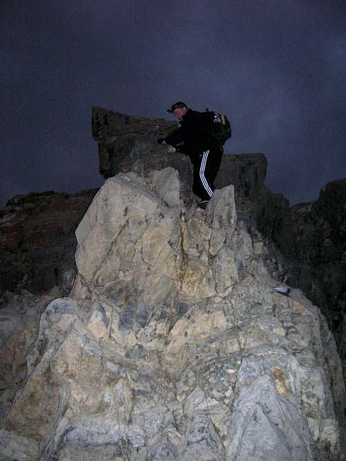
From Mackay Take U.S. Highway 93 21 miles north of Mackay to the Borah Peak Access Road (Birch Springs Road). This is between mileposts 129 and 130. Follow this road east for 3 miles to the trailhead.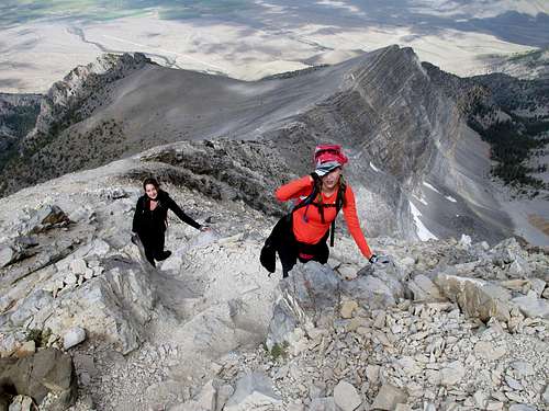 Scrambling On Chickenout Ridge
From Ketchum/Sun Valley (Highway 75)
Trail Creek road is one of the most scenic backcountry roads in Idaho that can be negotiated in a passenger vehicle and it's only a 50 mile drive to the bottom of Mt Borah from Ketchum or Sun Valley, Idaho. This breathtaking drive starts on pavement and ends on pavement but in-between it's gravel and narrows to a (white-knuckle) single lane road as it climbs nearly 1000' to Trail Creek summit. The gravel section can be pretty smooth after the road is freshly graded but later can turn into a tooth-rattling, dirt-eating, tire-flattening experience if washboard conditions develop. This is a seasonal road that closes in late fall and does not open until it's been plowed in the spring. If you watch the map closely you can cut about five miles off this drive by turning north on the Chilly shortcut before you get to Highway 93.
Red Tape / Camping
The mountain is located in the Challis National Forest. To camp in the campground at the trailhead requires a $5 fee.There are several nice camp sites near the trailhead. A toilet is available, but unfortunately there is no water. The elevation here is 7,200 feet so it gets cold at night.
The Joe T. Fallini Campground (formerly Mackay Reservoir Recreation Site) is the only recreational site in Challis that offers full RV hookups and features a diversity of other facilities.
 Scrambling Near The Summit
Lost River Ranger District P.O. Box 507 716 W Custer Mackay, Idaho 83251 (208) 588-3400 email: rerickson@fs.fed.us Office Hours: Monday - Friday 8:00 am - 4:30 pm
IdahoSummits - Aug 2, 2005 11:39 am - Hasn't voted
Untitled CommentGet up-to-date conditions or find partners by posting on the Idaho Outdoors Forum.
sam807 - Sep 19, 2017 1:03 pm - Hasn't voted
Final 800Before climbing Borah Peak, I spent a lot of time researching the climb. Most of the posts mentioned Chicken-out Ridge but only briefly described the final section of the climb--the last approximately 800 feet leading to the summit. I found this section much more challenging than Chicken-out Ridge. Despite it's reputation, Chicken-out Ridge consists of fairly stable, secure rock. The last 800 feet of climb beyond Chicken-out Ridge, however, is very steep, covered in loose rock, and, at times, doesn't have a lot of good foot holds. If you take your time, climb carefully, and exercise caution, you'll be fine. But don't underestimate this last section.
Alpinist - Nov 24, 2021 2:14 pm - Voted 10/10
Borah GlacierThe ice mass on the north slope of Mount Borah was officially named Borah Glacier in Feb 2021 by the Salmon-Challis National Forest. It is the only glacier in the state of Idaho. https://idahonews.com/news/local/idahos-only-active-glacier-officially-has-a-name-borah-glacier
gimpilator - Nov 24, 2021 2:17 pm - Hasn't voted
Re: Borah GlacierThank you for sharing this news and link.